Back home
Post #101

RU POV: Russian and Ukrainian advances from Day 935 to 937 of the War - Suriyakmaps

Sep 16, 2024 — Sep 18, 2024 War Day 935–937

Pictures 1 to 8 are from Day 935 (Monday 16 September), Pictures 9 to 13 are from Day 936 (Tuesday 17 September), and Pictures 14 to 17 are from Day 937 (Wednesday 18 September).

-------------------------------------------------------------------------------------------------------

A reminder that these maps are confirming updates from previous days (i.e. 12 to 48 hours delayed from each day).

Ukrainian Advance
14.48 km²
Overall (set): 11.49 km²
Russian Advance
62.82 km²
Net Change
-48.34 km²

Situation Snapshots

Imagery, commentary, and territorial changes from the period.

17 entries
Russian Forces Advance: 28.45 km²

Top Advance = 4.95km2, Bottom Advance = 23.50km2

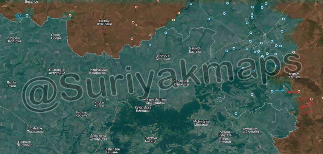
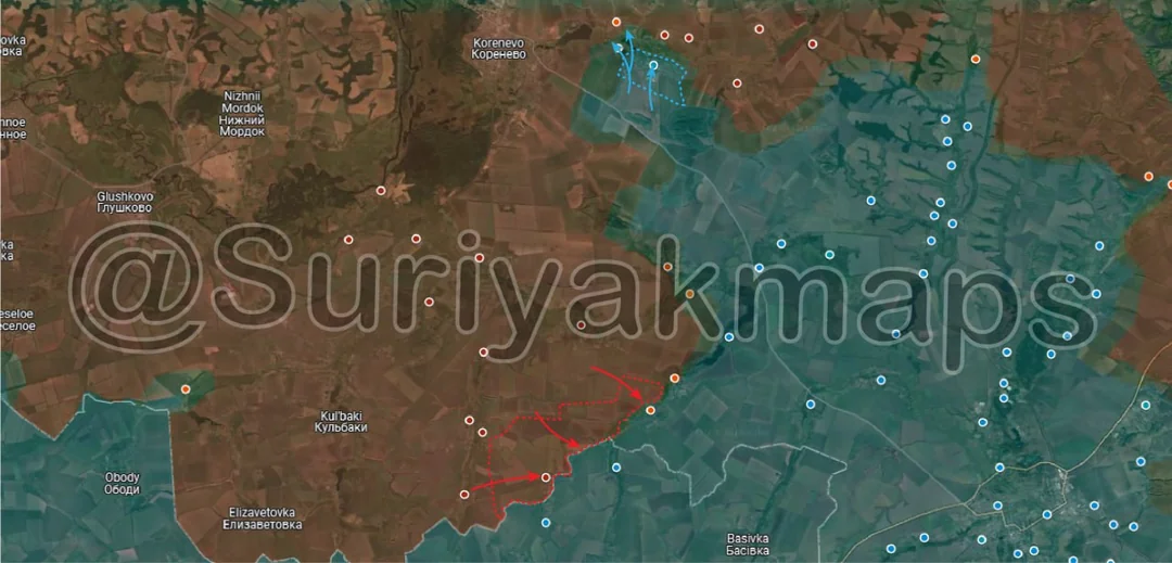
Starting with the Kursk front, Russia’s counteroffensive continues. On the western side, Russian assault groups advanced south from their positions in the fields around Obukhovka, forcing Ukraine to retreat and capturing all the fields and treelines all the way down to the border. This advanced also expanded their control of area north of Darino and Nikolaevo-Darino (red dots below k), where heavy clashes continue for another day. Ukrainian troops are desperately trying to hold these villages and the riverline, as losing them will force Ukraine to retreat over 6km further east, to the next village of Sverdlikovo.

Heavy clashes in Liubimovka and Tolstyi Lug (underneath the k) continue, with most of both villages falling into the greyzone. For now Russia controls the western side of Liubimovka, whilst Ukraine holds its positions along the eastern road. More POWs were also captured by Russia, as their count from the counteroffensive continues to increase.

Meanwhile, in the north Ukraine recaptured Olgovka over the past few days, whilst Russia’s attention was on the western side of the front. Whilst this advance was a win for Ukraine’s northern force on the Kursk front, they are still in an incredibly precarious situations, with only a single supply road and a forest area linking them to their supplies. There is a high chance the Ukrainian units in Olgovka will have to retreat from this area anyway, in order to avoid encirclement.
Russian Forces Advance: 4.73 km²

Top Advance = 2.82km2, Middle Advance = 1.50km2, Bottom Advance = 0.41km2

On the Oskil River front, Russian assault groups continue to deepen and expand their spearhead, capturing more fields on the northern side, as well as moving closer to the River itself and the main road. At this stage Russia is only 1.84km away from the main road (which provides supplies from Kupyansk) and approximately 3.4km from the left bank of the river. To reiterate the importance of these 2, reaching the river and crossing the main road will completely cut Ukrainian supplies to this front which travel from the north, leaving only the supplies from Lyman and Izyum which travel from the south of this road. The towns along the main road also (currently) only have trenchlines/defences designed for attacks from the east, not from attacks from the south or north (along the road itself)(pic below).
Russian Forces Advance: 7.84 km²

Advance = 7.84km2

To the south of the same front, Russian troops made a series of large advances over the past few days, capturing many fields and treelines as they close in on Nevske. Whilst this particular area had been relatively quiet over the past few months (as focus was on Makiivka, right at the top of the map), Ukraine’s removal of the 21st Mechanised Brigade has weakened Ukrainian positions enough here for these advances to take place.

The 21st Mech has been moved to reinforce the Kursk front, as shown by the footage of STRV 122/Leopard 2A5 (Video 1, Video 2, Video 3), CV-90s (Video 1), and Marder 1A3s (Video 1, Video 2). Whilst other Ukrainian units do use Marder 1A3s, and 1 other uses the CV-90s, only the 21st Mech Brigade uses the Leopard 2a5.
Ukrainian Forces Advance: 5.61 km²

Advance = 5.61km2

Whilst the advance in Picture 3 was occurring, Ukraine was making its own advance on the Oskil front slightly further south. Over the past few days Ukrainian troops increased the buffer around the town of Torske, recapturing positions they lost to Russia several months ago. This isn’t an offensive, and Ukraine will almost certainly dig into their positions, rather than try their luck with further advances east.
Russian Forces Advance: 0.37 km²

Advance = 0.37km2

On the Siversk front, Russian troops made a small advance north of Spirne (red dot under y), capturing a Ukrainian trenchline. Fighting on this fronts remains low-intensity, with far fewer troops involved compared to hot fronts like Pokrovsk and Kursk.
Russian Forces Advance: 0.82 km²

Advance = 0.82km2

Building on their successes from a few days ago, Russian assault units, using the forest as cover, have advanced west of the canal, assaulting and capturing several Ukrainian positions. Part of these advances can be seen in the videos here and here.

This marks the third area near Chasiv Yar where Russia has crossed the canal, with this one being particularly concerning for Ukraine due to the dense forest cover allowing for further Russian advances west.
Russian Forces Advance: 1.46 km²

Advance = 1.46km2

The big news items from Day 935 was in Toretsk of all places. On the southern side of the town, Russian assault groups were confirmed to have made large sweeping gains over the past few days, capturing most of the apartment buildings and houses on the southern side. This area has seen virtually no footage from Ukraine or Russia since Russia first took a foothold here almost a month ago, leading most sources to believe Russia was only focusing on its eastern foothold.

These advances put Ukrainian troops in Nelipivka (red dot bottom left) in a precarious position, as a further Russian advance west could completely cut them off. There is also another situation developing for Ukraine in the central area with this advance, but I’ll go over that further on in the analysis.
Russian Forces Advance: 0.37 km²

Advance = 0.37km2

On the Kurakhove/Selydove front, Russian troops captured most of Zhelanne Pershe, with the last few buildings (now in the grey zone) likely to fall under Russian control in the next few days. Due to this advance, Ukraine has had to speed up its withdrawal from the area east of the Vovcha River, as it is running out of crossings to supply its troops by. If Zhelanne Druhe falls to Russia, it spells the end for Ukraine’s hold on any territory east of the Vovcha River, as it’ll put Russian within striking distance of the final crossings.
Ukrainian Forces Advance: 8.87 km²

Top Left Advance = 0.93km2, Middle Right Advance = 7.94km2

Following on from Picture 1, heavy clashes continue across the Kursk front. On the western side, Ukraine was confirmed to have made a small bit of progress in its cross-border diversionary attacks (also known as counter counteroffensive). Despite the large amount of equipment and soldiers Ukraine has pushed through the 2 breaches, they remain bogged down in the border area, suffering heavy losses (see comment below).

On the southeastern side, Russia has continued its pressed its advantage following its capture of Borki and Spalnoe, capturing a few fields and attacking towards Plekhovo. Ukrainian troops in this area are not fairing well, and are suffering heavy casualties as they are driven back towards the Psel River. For now Ukraine is trying to hold the forest area between Plekhovo and Borki, but its questionable how long they will be able to, given the heavy Russian strikes (by drones and artillery), and additional reported Russian movements from north of Plekhovo, over the Psel River.
Russian Forces Advance: 1.99 km²

Advance = 1.99km2

Back over to the Chasiv Yar front, Russia has captured the last of the forest area east of the canal, as it continues its advance. This is the area where Ukraine was reported to have retreated from last week, however we were just waiting for confirmation that this actually occurred and Russia had in fact moved in.
Russian Forces Advance: 0.43 km²

Top Right Advance = 0.15km2, Middle Advance = 0.08km2, Lower Left Advance = 0.20km2

Following on from Picture 7, Russian assaults groups in eastern and central Toretsk continued making progress, capturing the last of the eastern apartment buildings, as well as expanding their control of the residential buildings around the central road. This advance also puts Russia right next to the very centre of Toretsk, with the town square and most of the surrounding buildings now in the greyzone.

In combination with the advances in Picture 7, this advance puts pressure on Ukrainian forces in southern Toretsk, who could very well be cut off if Russia advances just 1km further west (pic below).
Russian Forces Advance: 10.83 km²

Left Advance = 2.68km2, Right Advance = 8.15km2

Back to the Kurakhove/Selydove, following the capture of Zhelanne Pershe In Picture 8, Russia has cleared more of the fields to the east, with much of the remainder falling into the greyzone. As mentioned previously, Russian troops cannot simply rush through this area to chase the retreating Ukrainian troops, as it is heavily mined, and there are still rearguard forces left who can inflict heavy damage on careless advancing Russian units.

On the west side, Russian forces were confirmed to have captured the slag heap and mine complex in Ukrainsk, ending the battle for the town. From the reports and videos we have, the remaining Ukrainian troops stuck in that area were mostly wiped out, with some managing to flee through the fields.

From here, Russia will likely sweep the town for any stragglers, weapons or ammunition, set up their own positions on the slag heap, and begin moving west towards Tsukuryne, where Ukrainian troops fled to. There are several trench networks between Ukrainsk and Tsukuryne which will pose a challenge for Russia, but could be somewhat mitigated by circumventing them to the north.
Russian Forces Advance: 0.95 km²

Advance = 0.95km2

In Kostyantynivka, Russian troops captured the remainder of the fields around the O0532 road and northern residential area.
Russian Forces Advance: 1.31 km²

Advance = 1.31km2

On the Oskil River front, Russia continued closing the small pocket east of the Zherebets River, capturing another field. Most of the remaining area is now in the greyzone, bar a Ukrainian trenchline on the south side.
Russian Forces Advance: 0.38 km²

Advance = 0.38km2

Further south on the same front, Russia expanded its control of Makiivka, capturing some of the fields and a few warehouses on the southern side of the village.
Russian Forces Advance: 2.02 km²

Top Advance = 0.69km2, Bottom Advance = 1.33km2

Continuing on from Picture 12, Russian troops advanced along the treelines northwest of Ukrainsk, as they move closer to the abadoned mine complex and slag heap south of Selydove. If Russia can capture this area, they can set up ATGM positions on the slag heap to strike any Ukrainian vehicles travelling on the south side of Selydove, as well as cutting the road link from Selydove to Tsukuryne.

To the south, Russian troops launched assaults from the forest area towards the town of Hirynk, capturing several fields, and establishing a foothold on the northern side of the town. There are many conflicting reports from this area, with some Russian forces going to far as to say they have already taken the entire eastern side of the town. This is certainly a sensationalist claim, but I won’t rule out greater Russian progress than what Suriyak shows here, as some Ukrainian sources have reported a large grouping of Russian units already pushing deeper into the town. The situation will be cleared up over the next few days, once more information is released.

Hirnyk is incredibly important for Ukraine, as its loss would mean the end for Ukrainian positions on either side of the Vovcha River. If you’re wondering “what about Kurakhivka?” (just off map to the south), its supplies run from Hirnyk, with its only other option being a mishmash of exposed dirt or gravel roads around the mine.
Russian Forces Advance: 0.87 km²

Advance = 0.87km2

In Vodyane, Russian expanded the buffer around the town, capturing the fields on the northern side. You can see this advance in this video.

-----------------------------------------------------------------------------------------------------------------

Additional Point:

· Ukraine’s control of Kursk currently sits at 707.53km2. Ukraine’s maximum control in Kursk was approximately 930km2, short of their initial claim of 1000km2, and well below their revised claim of 1300km2.