Back home
Post #102

RU POV: Russian and Ukrainian advances from Day 938 and 939 of the War - Suriyakmaps

Sep 19, 2024 — Sep 20, 2024 War Day 938–939

icture 1 is from Day 938 (Thursday 19 September), and Pictures 2 to 8 are from Day 939 (Friday 20 September).

-------------------------------------------------------------------------------------------------------

A reminder that these maps are confirming updates from previous days (i.e. 12 to 48 hours delayed from each day).

Ukrainian Advance
2.61 km²
Overall (set): 2.61 km²
Russian Advance
39.97 km²
Net Change
-37.36 km²

Situation Snapshots

Imagery, commentary, and territorial changes from the period.

9 entries
Russian Forces Advance: 0.82 km²

Advance = 0.82km2

Following on from advances mentioned in the previous update, Russian troops in Makiivka have made further progress in the village, capturing the remainder of the southern warehouses, as well as crossing the Zherebets River and just south of the central bridge. Whilst Ukraine is trying to hold the village, with Russia now controlling most of Makiivka and with 2 footholds on the other side of the river the remainder of the village will likely fall to Russia over the next week.
Russian Forces Advance: 28.52 km²

Right Advance = 28.52km2

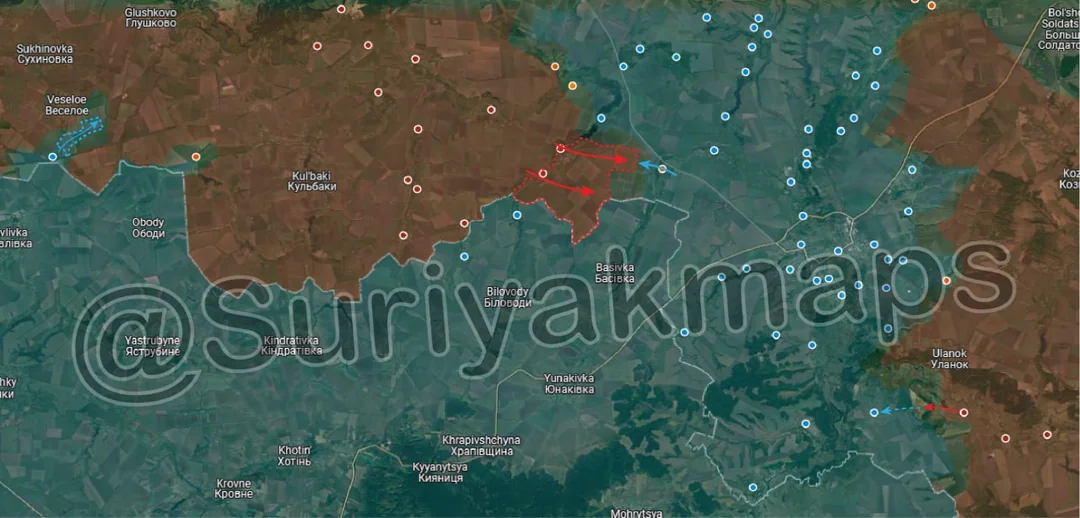
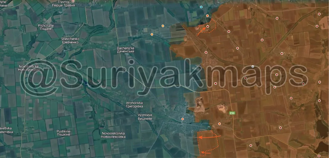
Developments continue across the Kursk front. On the western side, following over a week of assault attempts Ukrainian troops have made some more progress around Veseloe, capturing some of the treelines and a small section of the fields south of the village. They have still yet to establish a foothold in Veseloe, although their current movements suggest Ukraine is being forced to change strategy here and is now attempting to surround Veseloe, rather than try capture it head on as they have been. The waterlogged/swamp area northeast of Veseloe will prevent Ukraine from surrounding the village on that side, so they will have to attack towards the northwest if they wish to surround the settlement.

To the east of here, Russia troops broke through Ukrainian lines along the Snahist River, capturing both Darino and Nikolaevo Darino. The Russian assault units immediately continued their advance, and have captured most of the fields between the 2 previously mentioned villages, and the village of Sverdlikovo. Heavy clashes are currently occurring in the latter.

With this advance Russia has now stopped Ukraine from using Korenevo-Sudzha Road to supply its forces, as the front line is now close enough that it can no longer be used for that purpose, although obviously physical control is preferable. Originally Russia was aiming to cut the main road by capturing Liubimovka and Tolstyi Lug, although has been bogged down there for several days now. Capturing Sverdlikovo would have the same effect. Russia is closing in on being able to shut down Ukraine’s offensive through cutting supply lines, although still has a lot of work left to do so (expanded on in comment below).

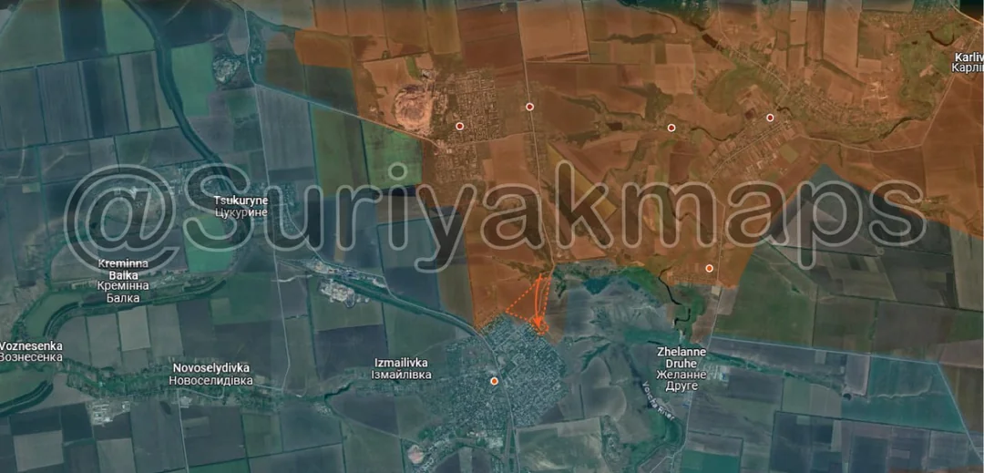
On the southeast side of the Kursk front, Russian troops have driven Ukraine back from the forests around Borki, with them now pulling back to take up positions in and around Plekhovo. This was mainly achieved through artillery and drone strikes, such as these (Video 1, Video 2), rather than infantry assaults, which is why this area has not been marked Russian-controlled yet.
Russian Forces Advance: 0.26 km²

Advance = 0.26km2

Following on from Picture 1, Russian troops made slightly more progress in Makiivka, capturing several more buildings on the western side of the river.
Russian Forces Advance: 0.10 km²

Advance = 0.10km2

In Toretsk, Russian assault groups started advancing out of the eastern apartment block area, capturing a number of residential buildings. The greyzone in the centre of the town (west of this advance) has also expanded, as heavy clashes are ongoing for the apartment blocks there.
Russian Forces Advance: 5.41 km²

Top Advance = 1.41km2, Bottom Advance = 4.00km2

On the Pokrovsk front, Russian troops recaptured Krutyi Yar, after Ukraine advanced into that area last week. Krasnyi Yar (slightly north) remains mostly in the greyzone.

South of Selydove, Russian troops captured several of the fields, as the begin to envelop the city on the southern side. This advance was made possible by the Russian capture of Ukrainsk mentioned in the previous update, as Ukrainian troops occupying this area were at risk of being cut off by further Russian advances.
Russian Forces Advance: 0.40 km²

Advance = 0.40km2

South of picture 5, Russian troops made some more progress in Hirnyk, capturing the school on the northwestern side of the town. Reports regarding the situation in the town are still mixed, so we will have to wait longer for further clarification.
Russian Forces Advance: 0.64 km²

Advance = 0.64km2

On the Kurakhove front, Russian assault groups, using the treelines along the railway as cover, have bypassed Ukrainian positions in Hostre (red dot above S) and entered the prison, where clashes are ongoing. If Russia can capture the prison and hold their positions, Ukraine will almost certainly have to retreat from this area, as they have cut one of the last 2 supply roads. Ukrainian troops still have a foothold on the southwestern side of Hostre, but will likely have to retreat back south over the river into Maksymilyanivka if their positions don’t improve soon.
Russian Forces Advance: 3.82 km²

Advance = 3.82km2

Russian assault groups crossed the Kashlhach River east of Prechystivka using bridging vehicles, and have advanced north through the fields, capturing several Ukrainian positions. Part of this advance can be seen in this video. Their goal here is to push north towards Novoukrainka and cut Ukrainian supplies to Vuhledar.

-----------------------------------------------------------------------------------------------------------------

Additional Point:

· Ukraine’s control of Kursk currently sits at 669.49km2. Ukraine’s maximum control in Kursk was approximately 930km2, short of their initial claim of 1000km2, and well below their revised claim of 1300km2.
Ukrainian Forces Advance: 2.61 km²

Left Advance = 2.61km2