Back home
Post #105

RU POV: Russian and Ukrainian advances from Day 942 and 943 of the War - Suriyakmaps

Sep 23, 2024 — Sep 24, 2024 War Day 942–943

Pictures 1 to 4 are from Day 942 (Monday 23 September), and pictures 5 to 8 are from Day 943 (Tuesday 24 September).

-------------------------------------------------------------------------------------------------------

A reminder that these maps are confirming updates from previous days (i.e. 12 to 48 hours delayed from each day).

Ukrainian Advance
2.73 km²
Overall (set): 2.73 km²
Russian Advance
63.79 km²
Net Change
-61.06 km²

Situation Snapshots

Imagery, commentary, and territorial changes from the period.

8 entries
Ukrainian Forces Advance: 2.52 km²

Left Advance = 0.89km2, Upper Right Advance = 1.63km2

Starting off with the Kursk region (daring today, aren’t we?); Ukraine was confirmed to have made some small gains in two different areas, capturing another treeline south of Veseloe, as well as expanding their control over the small forest area and adjacent field northeast of Malaya Loknya. Information regarding Ukraine’s distraction/counter-counteroffensive in Western Kursk is sparse and/or delayed, but at this stage its safe to say it has mostly stalled out. They are still attacking in those 2 areas, but the amount of equipment used has decreased compared to the large columns/groups of the first week.

There are heavy clashes ongoing in multiple other areas of this front, however no territorial changes can be confirmed yet.
Russian Forces Advance: 1.19 km²

Advance = 1.19km2

Continuing on from the previous update, Russian troops captured another field on the south side of their spearhead towards the Oskil River. As mentioned previously, Russia is still probing Ukrainian positions and preparing for an assault on one of the three villages (Hlushkivka (top blue dot), Kolisnykivka and Kruhlyakivka), which will likely be launched sometime in the next few weeks. Ukraine still has a number of trenches and defensive positions east of those settlements, which it will try to hold to prevent Russia from cutting off the main road.
Russian Forces Advance: 5.01 km²

Middle Left Advance = 1.96km2, Bottom Middle Advance = 3.05km2

On the Selydove/Kurakhove front, Russian forces continuing making gains in multiple areas. On the west side, following their capture of the slag heap next to the abandoned mine yesterday, Russia continued its advanced, launching more assaults out into the fields and to the railway line, capturing them. There is a video of part of this assault (2 Russian BMPs reaching the railway treelines, dropping troops, and leaving), however I can’t link it as it has not been posted to the sub. One of the notable aspects of this video is how little resistance they faced, with only a few mortar/artillery rounds landing vaguely nearby over a several minute span. As mentioned previously, Russia is looking to surround and capture Tsukuryne, with the Russian squads in the railway area likely to use it as cover to attack the northern side of the town.

To the southwest, Russian troops advanced out of Zhelanne Pershe, and captured Zhelanne Druhe. This leaves Ukraine with only the crossings east of Kurakhivka to get over the Vovcha River. Ukraine has already been pulling its troops out of this area, starting over a week ago, but still has some forces trying to stall Russia it will have to evacuate.
Russian Forces Advance: 3.71 km²

Left Advance = 3.35km2, Right Advance = 0.36km2

The Russian offensive on the Vuhledar front continues, with the situation deteriorating even further for Ukraine. On the western side of the town, Russian troops continued advancing, capturing several trenchlines in the field, as well as the remaining destroyed warehouses north of Pavlivka (red dot under S). You can see part of that advance here, with several POWs taken.

On the east side of the town, forward Russian recon groups advanced through the suburbs on the eastern side of Vuhledar, and entered the town itself (seen here). These are not assault groups, but rather an initial squad who are securing a foothold and observing the area in order to enable the actual Russian assault groups to move in later.

I’ll expand on some other points regarding Vuhledar further down.
Russian Forces Advance: 21.51 km²

Advance = 21.51km2

Back to the Kursk region, over the past few days Russian troops have advanced on the southern side of the front towards Plekhovo (blue dot under m), which was only confirmed today. Russian assault groups have made good progress in the fields to the south and the forest areas between Plekhovo and Borki (red dot under a), capturing them and driving Ukraine back towards Plekhovo itself. Part of these attacks can be seen here, with Russian drones and artillery hitting Ukrainian soldiers in the forest and town areas. The Ukrainian unit/s on this part of the Kursk front are struggling, primarily due to having far less equipment allocated to them, and with a precarious supply route of pontoon bridges over the Psel River (which are being targeted).

Ukraine is unlikely to be able to hold this area for much longer, as there is a high risk of troops getting cut off if the fighting begins within Plekhovo, and if they lose the few pontoon bridges,evacuation/retreat will be very difficult. Completely cutting them off however is almost certainly not going to happen, as the dense forest south of Plekhovo and the border make a Russian advance on the southern side difficult, and provides a last line of retreat for Ukraine.
Ukrainian Forces Advance: 0.21 km²

Advance = 0.21km2

On the Northern front, following months of fighting in Vovchansk, Russian troops in the town were forced to pull out of the aggregate plant due to constant Ukrainian pressure, with Ukraine finally taking control today. There are some pictures and a video of the aggregate plant, if you wanted to see what it looks like now. This advance finally removes the thorn in side of Ukraine in Vovchansk, as the few Russian troops inside prevented them from gaining full control over the southern area near the river.

I have to stress however that this advance does not critically change the situation in the town, and progress is unlikely to speed up for either side. The battle for Vovchansk is still a slow static battle, primarily fought with drones, and will almost certainly not end in the near future.

In case it needed to be clarified, the small number of Russian troops in the plant were never truly cut off from supplies, despite many Ukrainian claims, hence why they were able to last as long as they did. The “encircled aggregate plant” narrative has worked against Ukraine here, as its resulted in the logical question of how they were unable to take it despite the plant being encircled for 3+ months….
Russian Forces Advance: 22.68 km²

Left Advance = 1.17km2, Right Advance = 21.51km2

Following on from Picture 3, Russian progress continued from the previous advances. On the west side of Ukrainsk, Russia took control of the field and the rest of the treeline, which had fallen into the greyzone after Russia captured the treeline just south of it.

On the east side, Russian forces are confirmed to have cleared most of the fields east of the Vovcha River, after Ukraine withdrew from those areas last week. Ukraine still maintains a presence in the fields further south however, although will likely retreat from there in the coming days, as mentioned in picture 3.
Russian Forces Advance: 9.69 km²

Middle Advance = 0.19km2, Bottom Left Advance = 5.81km2, Bottom Middle Advance = 3.69km2

Following on from Picture 4, Russian advances continue across the Vuhledar front, with the final stages of the battle for the town in full swing. On the western side, Russian troops have captured most of the remaining fields north of Prechystivka (red dot under @), and have settled along the southern side of a small stream. They will likely not advance further north until Vuhledar is wrapped up, and/or preparation for an advance towards Novoukrainka (blue dot under @) is completed.

To the northwest, Russian troops were confirmed to have captured the remainder of the number 3 mine complex, following a week of fighting. Fighting stalled after the initial assaults due to the central pithead of the mineshaft being boobytrapped/mined, forcing Russia to destroy the structure themselves (video 1, video 2) rather than letting Ukraine do so when it would be most opportune for them. This denies Russia an incredibly dominant height, helping Ukraine. The remainder of the fighting for the mine was over the northwestern side, where Ukraine had holed themselves up in the buildings and trench network adjacent. This took several days, with Russia gradually wiping out or routing the remaining Ukrainian troops (Video 1, Video 2, Video 3, Video 4). From here, Russian troops will consolidate their positions, before advancing towards the farm to the northwest.

Around Vuhledar, Russia continued to encircle the town, capturing the fields and a trench network to the northwest. Vuhledar itself is under heavy bombardment (Video 1, Video 2, Video 3), with Russia trying to drive the remaining Ukrainian troops underground, or at least further back into the town. There are definitely still Ukrainian soldiers in Vuhledar, despite some claims, as we have videos of Russia striking them with drones.

In the previous update (as at end of Sunday 22nd), I said Ukraine had left it late, and would take casualties, but could still get some soldiers out of Vuhledar if they left that day. With these recent Russian advances, that is no longer an option.

There remains a less than 3.30km gap (from Russian positions on either side) for Ukraine to retreat through, but in reality it’d be closer to 1.50km, as you can’t flee right next to the enemy. This 1.50km gap is completely open fields, with little cover in sight, and no roads. Vehicles also aren’t an option at this stage, as they would certainly be hit by the myriad of Russian drones, ATGMs and artillery watching the area, meaning any retreating soldiers would need to run on foot (we already have footage of vehicles not even making it out of the town).

Thus, the only options left for the soldiers of the 72nd and 110th Mechanised Brigade who are still within Vuhledar are:

Surrender to Russia (as we have seen a number of others here do)

Hide in the depths (underground) area of Vuhledar, and fight to the death

Run (at minimum) 5km+ through the open fields to Ukrainian positions further northwest, all the while being hit by drones, ATGMs and artillery.

None of these options are ideal for these soldiers, but it’s a choice they’ll have to make soon, as time is quickly running out.

-----------------------------------------------------------------------------------------------------------------

Additional Point:

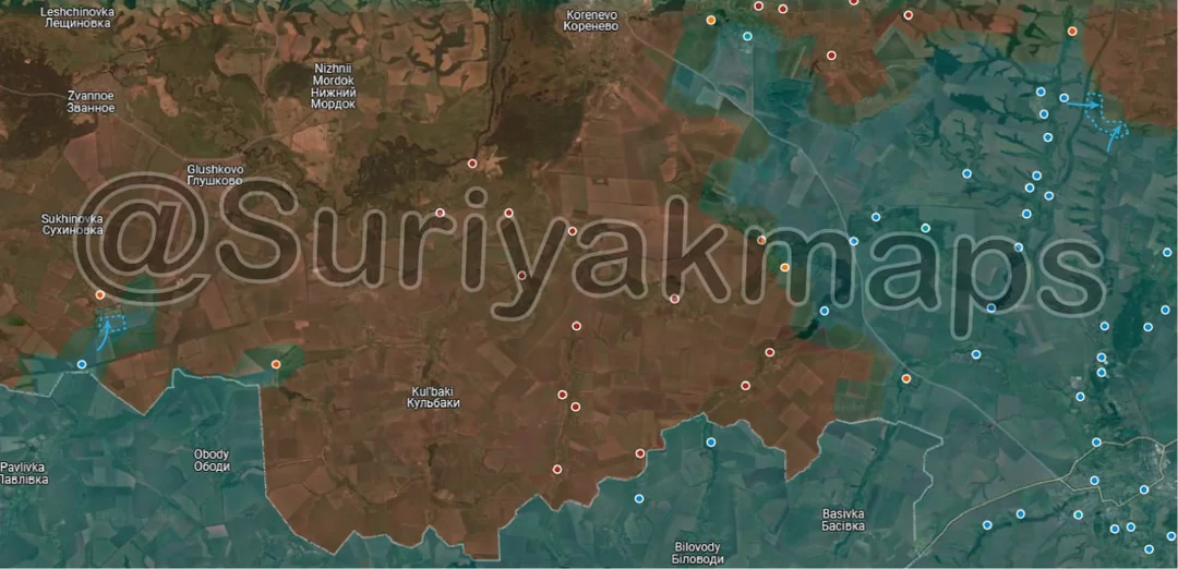
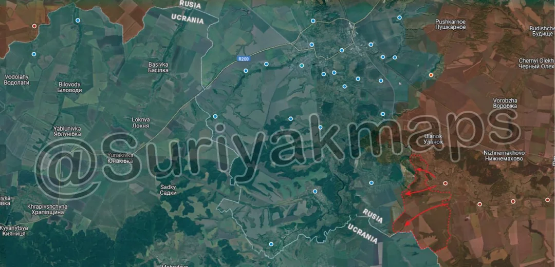
· Ukraine’s control of Kursk currently sits at 660.57km2. Ukraine’s maximum control in Kursk was approximately 930km2, short of their initial claim of 1000km2, and well below their revised claim of 1300km2.