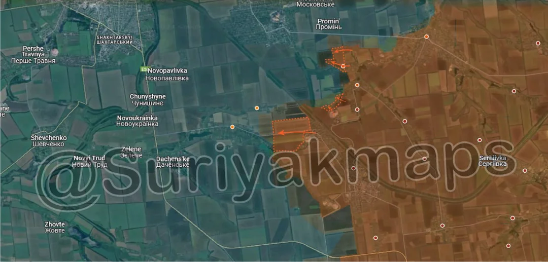
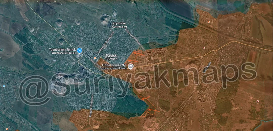
Back home
Post #107

RU POV: Russian and Ukrainian advances from Day 946 to 948 of the War - Suriyakmaps

Sep 27, 2024 — Sep 29, 2024 War Day 946–948

Pictures 1 to 3 are from Day 946 (Friday 27 September), pictures 4 to 5 are from Day 947 (Saturday 28 September), pictures 6 to 8 are from Day 948 (Sunday 29 September).

-------------------------------------------------------------------------------------------------------

A reminder that these maps are confirming updates from previous days (i.e. 12 to 48 hours delayed from each day).

Ukrainian Advance
3.48 km²
Overall (set): 8.34 km²
Russian Advance
25.27 km²
Net Change
-21.79 km²

Situation Snapshots

Imagery, commentary, and territorial changes from the period.

8 entries
Russian Forces Advance: 0.38 km²

Top Advance = 0.18km2, Bottom Advance = 0.19km2

Starting off with Toretsk, Russia continues to make gradual progress in capturing the town. East of the town centre, Russian troops captured several more streets of residential buildings, as they begin to straighten the front line. To the south, a separate Russian unit has begun clearing the forest area, capturing the outermost ‘blocks’. The goal of this advance is push through the forest and begin attacking the southern suburbs of Toretsk from the eastern side.
Russian Forces Advance: 2.92 km²

Top Advance = 0.56km2, Middle Advance = 0.32km2, Bottom Advance = 2.04km2

On the Pokrovsk front, following on from their progress in recent days, Russian troops captured the remainder of Mykolaivka, as well as a trench network in the field north of the village. Additionally, just south of here, Russia also began advancing north from the slag heap capturing part of the fields. The goal of these advances is to head towards Myrnohrad, using the treelines along the railway as cover for an eventual assault on the city.

To the southwest, Russia also continued its attacks towards Lysivka and Sukhyi Yar, capturing some of the fields. Fierce Ukrainian resistance in this area has so far mostly halted their advance attempts in this area, although they are gradually making progress towards capturing these settlements.
Ukrainian Forces Advance: 1.42 km²

Top Advance = 0.86km2, Bottom Advance = 0.56km2

On the Vuhledar front, Russia continued making gains around the pocket, capturing the field south of coal mine number 3 (above the i), as well as making a small advance west of coal mine number 1. Ukrainian troops within Vuhledar itself are still trapped, with the few evacuation attempts we have seen all failing due to Russian fire control over the fields north of the town. As mentioned previously, the remaining Ukrainian forces in Vuhledar (likely <1000), cannot escape, and will either have to surrender, or fight to the death. Russia has allegedly made several attempts to get these troops to surrender, however its unclear how many have taken up the offer, or how long Russia will keep this offer open for.
Russian Forces Advance: 2.62 km²

Top Advance = 0.14km2, Middle Left Advance = 2.15km2, Middle Advance = 0.33km2

Following on from Picture 1, Russian troops made some more progress in Toretsk, capturing more of the residential area, this time south of their main spearhead in the town.

Around Niu-York, Russian troops cleared the fields and treelines on the northwest side of the town, as well as advancing within Nelipivka (dot below a), capturing more buildings in the centre of the village. Ukraine is unlikely to be able to hold Nelipivka for much longer, due to being driven back to the northern side, which has fewer buildings to hold from.
Russian Forces Advance: 4.05 km²

Top Advance = 0.88km2, Middle Advance = 1.51km2, Bottom Advance = 1.66km2

On the Selydove front, Russian attacks have ramped up over recent days, making progress in several areas. On the north side, Russian troops used the treelines on either side of the stream to advance all the way up towards the southwestern side of Selydove, close to one of the last few supply roads. The treelines west of this advance along the railway will also likely fall to Russia within the next few days, as they already control part of this area (under the i and y). I’ve mentioned what Russia is trying to do here before, but essentially their goal is to cut the supply roads to Selydove in order to isolate the city, and force Ukraine to abandon it, rather than go through a lengthy urban siege. Whilst Russia has made good progress towards this goal on the south side, they haven’t had much luck on the north side due to constant Ukrainian counterattacks.

To the south, Russian troops captured some of the fields around Tsukuryne (red dot under y), as they approach the outskirts of the town. Ukrainian troops in Hirnyk (off map south) have also been isolated from Tsukuryne, with Russian assault groups capturing part of the mine complex between the 2 towns. This leave Hirnyk with only 2 supply routes, and Tsukuryne gradually being surrounded on 3 sides. Russian assault of the latter will likely begin within the next day or 2.
Ukrainian Forces Advance: 2.06 km²

Advance = 2.06km2

Over on the Oskil River front, Russian continued its advances in Makiivka, finally capturing the last few buildings in the village. Russian troops will still need to clear the few forest areas next to the settlement to protect it from counterattack to ensure it stays under their control, but should be able to achieve this within the next day or 2.
Russian Forces Advance: 12.10 km²

Top Left Advance = 8.34km2, Lower Right Advance = 3.76km2

Over on the Kursk front, Ukraine made some more progress after several weeks of attacks south of Glushkovo. Following more mechanised assaults, one seen here and another here, Ukraine has advanced on the flanks of Veseloe, capturing some of the fields and buildings on both sides of the village. I disagree somewhat with Suriyak’s assessment here, as he shows a number of buildings on both the west and south side of the village as Ukrainian controlled, with the remainder in the greyzone, whilst I think almost all of the village should be marked greyzone, as the footage we have so far of Ukraine advancing on the flanks also shows those same assault groups being wiped out. There isn’t actually any footage from within the settlement to confirm they are there, but this should be cleared up over the next few days.

On the complete opposite side of the Kursk front, Russian troops launched a mechanised assault south of Plekhovo, capturing some fields (and losing at least 1 tank). Whilst they don’t currently have a foothold in the village, they will likely enter it within the next day or 2, as Ukraine is slowly pushed out.
Russian Forces Advance: 3.20 km²

Top Advance = 1.43km2, Bottom Left Advance = 0.67km2, Bottom Right Advance = 1.10km2

On the Selydove front, Russian troops made a small advance north of the city, capturing another field.

To the south, Russian troops made 2 separate advances into Tsukuryne, one from the railway area using the treelines as cover, and another one from across the fields, capturing part of the east side of the town. Between this advance, and the advance in picture 5, this has isolated Ukrainian troops in central Tsukuryne. If Ukraine cannot counterattack against Russian troops along the railway line, they will be forced to retreat back from the entire eastern side of the town. This will allow Russian assault groups to establish in the town (coming from Ukrainsk), and push Ukraine out of the area west of the railway.

-----------------------------------------------------------------------------------------------------------------

Additional Point:

· Ukraine’s control of Kursk currently sits at 665.03km2. Ukraine’s maximum control in Kursk was approximately 930km2, short of their initial claim of 1000km2, and well below their revised claim of 1300km2.