Russian Forces
Advance: 2.61 km²
Advance = 2.61km2
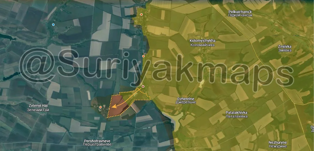
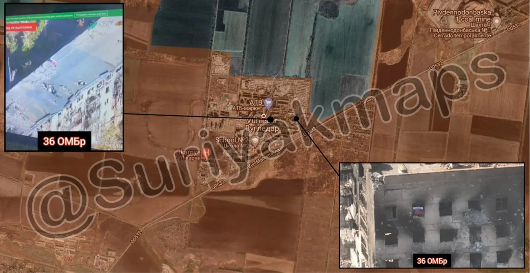
The big news of this update, and really the whole week, was the confirmation that Russia has captured Vuhledar (Ugledar). This happened in the morning of Day 951, as the last Ukrainian troops in the town either surrendered or tried to flee (following the last minute permission to retreat 1.5 days before). The actual advance compared to the previous update is in a picture below.
To address the elephant in the room; what happened to the 500-1000 Ukrainian troops who were in and around Vuhledar in the last week? As is typical of this war, reports by both Russian and Ukrainian sources were all over the place, with claims of hundreds of POWs (but they won’t show them) on one side, and assertions that most Ukrainian troops escaped due to Russians not noticing the retreat on the other.
But filtering out the absurdist statements, there is a very clear picture described and shown in the reports (both UA and RU) and videos that we have so far; most of the Ukrainian troops didn’t make it out of the pocket. As seen in the videos I have linked in previous reports (as well as this and this), Russia was shown to be heavily striking anything that moved in and around Vuhledar, destroying evacuation transports and killing the soldiers who tried to flee on foot. This article has some chilling first hand accounts from a Ukrainian soldier of what they faced. Even more shocking have been the reports coming from Ukrainian soldiers in the 72nd Brigade, with multiple Ukrainian sources now reporting that most of the 72nd Mechanised Brigade was wiped out. One soldier from the Brigade said on Telegram that only 30 people survived out of the 350 in his battalion, and the other battalions and units in the area suffered a similar fate. Another soldier mentioned on Facebook that of the 50 conscripts that arrived to reinforce his unit, only 4 actually made it to the front lines, as the rest were either unfit to fight (being old and sick), deserted, or were wounded.
Whilst the above is catastrophic for Ukraine, losing a significant number of troops and a fortified town that has held for years, I can’t say this is unexpected. If you’ve paid attention to my analysis and updates, you’ll know I’ve been reinforcing for almost a week now that Ukraine left it too late to leave, and the remaining troops were essentially doomed. I also predicted that Vuhledar would fall within 1 week, which ended up occurring almost exactly 7 days after I mentioned it.
As for what happens next, Russian troops will likely spend a few days/a week properly clearing out all of Vuhledar, whilst other units prepare for their next moves. Their targets will almost certainly be Bohoyavlenka and Novoukrainka, 2 towns situated in the fields north and northwest of Vuhledar respectively. Russia has already begun moving in on the forming, with an advance to the west mentioned in the last update. Russia will need to get a move on, as whilst the weather has been very good for them, the Autumn rains will not stay away forever, and this area is made up of almost entirely dirt roads of open fields (i.e. lots of mud). If Russia can capture, or at least reach both towns before the weather turns for the worse, they will be able set themselves up to cut the main road between Kurakhove and Velyka Novosilka, both key supply hubs (pic below).