Back home
Post #111

RU POV: Russian and Ukrainian advances from Day 954 to 957 of the War - Suriyakmaps

Oct 5, 2024 — Oct 8, 2024 War Day 954–957

I’ve been very busy with work this week, so there was a bigger gap between posts than usual. This will catch you up to the most recent update, and there is a lot to cover.

-------------------------------------------------------------------------------------------------------

Pictures 1 to 5 are from Day 954 (Saturday 5 October), Pictures 6 to 10 are from Day 955 (Sunday 6 October), Pictures 11 to 15 are from Day 956 (Monday 7 October), and Pictures 16 to 20 are from Day 957 (Tuesday 8 October).

Perfectly balanced, as all things should be.

-------------------------------------------------------------------------------------------------------

A reminder that these maps are confirming updates from previous days (i.e. 12 to 48 hours delayed from each day).

Ukrainian Advance
24.45 km²
Overall (set): 24.74 km²
Russian Advance
38.87 km²
Net Change
-14.42 km²

Situation Snapshots

Imagery, commentary, and territorial changes from the period.

20 entries
Russian Forces Advance: 4.27 km²

Advance = 4.27km2

Starting off with the Oskil River front, Russia continues to make progress, capturing several more fields and a few trenches, this time on the northern side of the spearhead. At this stage Russia has a 6.7km wide area of the front right next to the Ukrainian line, and thus can attack any one of the three towns (Hlushkivka, Kolisnykivka and Kruhlyakivka) in this area in their attempt to cut the supply road here. For now however Russia seems to be content with heavily shelling Ukrainian positions and widening the front, as the probe for weaknesses to attack.
Russian Forces Advance: 4.95 km²

Top Right Advance = 2.80km2, Lower Left Advance = 2.15km2

Onto the Kursk front, Russian troops made a small advance on the northern side, recapturing a few fields. To the west, Ukrainian troops recaptured one of the fields and treeline the lost a couple of days ago in a Russian counterattack. They are still attacking in this area, but have so far failed to regain their lost positions around Veseloe (red dot under u).
Russian Forces Advance: 3.65 km²

Advance = 3.65km2

Back to the Oskil River front, this time on the southern side, Russian troops launched another series of attacks, this time east of Terny (blue dot above the u), capturing multiple fields and treelines. This is part of Russia’s campaign on this front, where they constantly rotate the direction of attack, exploiting Ukraine’s lack of manpower and particularly equipment to hit them where they are weakest.

Ukrainian troops in Terny are in a difficult position, as Russia’s recent advances in Nevske (just off map to the north), means they are having to defend from both the eastern and northern sides, all with their backs up against the reservoirs. If Russia does reach the village itself, Ukrainian troops will almost certainly have to withdraw to the other side of the Zherebets river, rather than risk being cut off in the settlement whilst fighting due to there being minimal crossings.

Russian Forces Advance: 0.22 km²

Advance = 0.22km2

Following on from the previous update, Russian troops on the Selydove/Kurakhove front made some more progress within Tsukuryne, capturing the last of the residential buildings on the west side of the town. Ukrainian troops are now limited to their positions in the farm/warehouse area, which are quite exposed due to how separated they are.

If Ukraine cannot hold this area, they will be forced to retreat west into the treelines, as well as to the south to Kreminna Balka, although it too is quite exposed due to being quite small and the buildings spread out. There was also a push towards Novoselydivka (off map to the south), with Russian troops at least reaching the village, however the results of the attack are unclear (pic below).
Russian Forces Advance: 0.71 km²

Advance = 0.71km2

Down south, Russian troops in Kostyantynivka launched a mechanised assault towards Antonivka, using a tank and several IFVs. The assault was defeated, with 3 of the vehicles being knocked out/destroyed, however Russian troops were able to advance to the outskirts of Antonivka without meeting any Ukrainian troops on the ground. Ukraine is thus likely holding this area from within the town itself, rather than exposing its troops in the field area Russia advanced through. Russian troops will almost certainly try another assault from this area in the future.
Ukrainian Forces Advance: 6.72 km²

Advance = 6.72km2

Following on from picture 2, Ukrainian troops captured the fields between the border and their previous advances. This area has not been occupied by Russia since Ukraine launched there attacks several weeks ago, but Ukraine had yet to move in as it was focusing on attacking Veseloe (red dot under y). Russia is still pounding Ukraine in this area (Video 1, Video 2, Video 3), but has not been able to completely drive them back over the border, due to the constant introduction of new forces. Russian command likely aren’t too upset by this however, as they have still been able to keep Ukraine limited to one particular border breach here, and are inflicting heavy losses on Ukraine for fewer of their own.
Russian Forces Advance: 1.28 km²

Advance = 1.28km2

Back to the Oskil River front again, Russian troops recaptured the fields and forest area west of Novovodiane, which they lost to Ukraine in a counterattack back in late August (Day 910).
Russian Forces Advance: 0.67 km²

Advance = 0.67km2

On the Pokrovsk front, Russian troops captured the last part of Hrodivka, confirming full control of the settlement. Russia has functionally controlled Hrodivka for quite a while now, but technically did not control the whole town as there were a few (<10) buildings scattered on the outskirts they had been unable to capture until now, due to Ukraine using the adjacent treelines/forested areas to defend from.

From here, Russian troops will likely consolidate positions in Hrodivka, as they prepare for their assaults towards Myrnohrad (top left of map). They will first have to seize control of the trench networks in the fields however.
Russian Forces Advance: 2.45 km²

Top Advance = 0.74km2, Bottom Right Advance = 1.71km2

Back to the Selydove/Kurakhove front, Russian troops made a small advance northeast of Hirnyk, capturing some treelines. Ukrainian troops in that hilly area between this advance and Zhelanne Druhe (so above the k) have so far been able to hold their positions, due to the dense trench network with multiple underground bunkers. There is however a risk that they could be cut off from their own lines, if Russian troops advance in that small area between the trench network and Hirnyk.

To the east, Russian troops captured more of the fields east of the Vovcha River, as they slowly clear the area, and Ukraine progressively falls back.
Russian Forces Advance: 0.15 km²

Advance = 0.15km2

The news this week that caused quite a stir was video footage of Russian troops operating in Kamyanske, Zaporozhia, the opposite side of the river from Russian positions. To give you a quick history lesson, Russian troops reached this area in early 2022, but were unable to cross the river into Kamyanske due to Ukraine setting up a defensive line there. Russian troops set themselves up in Verkhyna Krynytsya (south side), and haven’t moved since, with the only activity going on anywhere near here being a brief period of Ukrainian advances to the east during the 2023 counteroffensive, although they quickly died down. Thus, Russia and Ukraine have occupied either side of the river for well over 2 years now, with virtually no fighting going on here for that whole time.

This advance was almost certainly enabled by the drop in water levels following the destruction of the Kakhova Dam, which drained the reservoir and exposed more land, which whilst waterlogged/unstable, could still be crossed on foot. To burst the bubble of those gleefully awaiting a ‘Zaporizhzhia offensive’, this is unlikely to occur right now. The group that crossed the river is almost certainly a DRG, and is just probing Ukrainian positions and causing havoc by attacking from a completely unexpected area. For now they are set up in a small section along the banks of the Dnieper, so we will have to wait and see how they fair, and what Ukraine’s response is.
Ukrainian Forces Advance: 16.53 km²

Top Advance = 0.66km2, Middle Advance = 6.80km2, Bottom Advance = 9.07km2

Back to the Kursk front once again, Russian troops were unable to maintain their positions around Tolstyi Lug and Sverdlikovo, and were forced back by Ukraine. This gives Ukraine a little bit of breathing room around those settlements, but renewed Russian attacks could force them back, as these are open, exposed fields. Russian troops also made a small bit of progress inside Liubimovka at the same time, captured the central area of the village.
Russian Forces Advance: 0.11 km²

Advance = 0.11km2

On the northern/Kharkiv front, 2 weeks after Ukraine’s GRU announced the capture of the aggregate plant, Russian troops recaptured it. This took place after multiple failed assaults (Video 1, Video 2), and many heavy bombardments, which forced Ukraine out from their positions in the plant. Despite this advance, Vovchansk remains a very static part of the front line, owing to the sheer volume of destruction wiping out most usable positions in the central area (far northern and southern sides still mostly intact).

I actually somewhat disagree with Suriyak’s mapping here, as I think it would be more accurate to show most of the central town in the grey zone, with small pockets of actual control at the apartment buildings and aggregate plant, given they are really the only buildings still usable.
Russian Forces Advance: 3.85 km²

Top Advance = 0.21km2, Bottom Advance = 3.64km2

Following on from Picture 1, Russian troops made a very small advance on the north side of their spearhead, capturing another treeline as they head towards Pishchane. No that’s not a typo, there really are 2 villages called Pishchane within 9km of each other (one just off map north, other is red dot above y).

To the south, Russia closed out the last bit of fields and treelines north of Stelmakhivka (bottom red dot), including the final buildings of the village, confirming its capture. This advance is notable as it also means Russia now controls the majority of the eastern side of the Zherebets River, from its beginning north of Stelmakhivka, all the way down to the south of Nevske (about 50km). Whilst there are other rivers between here and the Oskil, none are quite as long, and none have the same ideal north to south orientation that matches the frontline.
Russian Forces Advance: 0.05 km²

Advance = 0.05km2

In Chasiv Yar, Russian forces made another small advance in the eastern suburbs, capturing another block. To reiterate, fighting here is incredibly slow and mostly positional, owing the numerous units both sides have deployed here and the large number of drones and artillery being used.

Russian Forces Advance: 7.02 km²

Left Advance = 6.25km2, Right Advance = 0.77km2

Over on the Vuhledar front, Russian troops advances west of Prechystivka (red dot above r), capturing many fields as well as the village of Zolota Nyva (red dot above @) in a mechanised assault (Video 1, Video 2, Video 3). Zolota Nyva was not particularly well defended, as evidenced by the lack of artillery and quick capture of the village by Russian troops, and only really survived this long as Russia was focusing on capturing Vuhledar over the past few weeks.

At this stage its unclear whether Russia intends to head north towards Shakhtarske, or continue west towards Velkya Novosilka, however I believe the former is more likely, as attacking the latter from this direction is disadvantageous due to being funnelled into several minefields and Ukrainian trench networks.

Over to the east, Russian troops made a small advance north of Vuhledar, capturing another field near the mine.

Russian Forces Advance: 0.53 km²

Advance = 0.53km2

Following on from Picture 3, Russian troops made a small advance south of Nevske, capturing a field.
Russian Forces Advance: 3.88 km²

Advance = 3.88km2

On the Siversk front, we finally received more information regarding Verkhnokamyanske (red dot above y), which I talked about in my last update. Video footage has confirmed the entire town is under Russian control now, with Ukraine retreating back towards their positions around Siversk. As previously mentioned, this puts Ukraine in a difficult position, as it was the last settlement on the eastern side before Siversk, with Russian now only 3.8km away from the military hub. Ukraine still has a well built defensive line around the eastern side of Siversk, so the town will be very difficult to take, however once the fighting begins it will lose its ability to act as a supply hub for this front, with the next closest suitable settlement being Mykolaivka, 20km west.

Russian troops will almost certainly expand their control north and south of Verkhnokamyanske (the flanks), before attempting to push forwards towards Siversk.
Russian Forces Advance: 4.08 km²

Advance = 4.08km2

Only a little further north of the previous advance, Russian troops were also quite active around Bilohorivka. Russian assault groups were confirmed to have cut advanced through the northern hills, capturing many Ukrainian dugouts and positions from which they contested Bilohorivka, and have entered the eastern side of Hryhorivka (blue dot above i). Early reports from this day also suggest they have already captured the whole settlement (or rather the remaining ruins), however Suriyak is being conservative/cautious here and waiting for a bit more confirmation, which we will likely get in the next update.

For their part, Ukrainian positions on the Siversk front have deteriorated significantly in the past week alone, going from strongly holding most of their defence lines as they have for several years, to being pushed back tens of km2. To be completely frank, I had mostly written off the Siversk front for 2024 as of a week ago, and had already started writing some early notes about the lack of Russian progress here for a 2024 breakdown post.

What is most interesting about these advances (Pictures 17 and 18) is that for all intents and purposes nothing has changed on this front that should cause Ukraine to be pushed back. None of the units deployed here were redeployed to Kursk (as happened for other fronts), and as far as I am aware Russia has not introduced new units here either. Russian command looks to have simply found some weak points in the Ukrainian lines, or has slowly attritioned them over months, to the point where they are now able to advance easily in places they were thoroughly stuck in before.

If Russian troops are able to continue making progress on the eastern side of Siversk, Ukrainian positions in the fields inbetween these advances will become untenable, forcing them to retreat back to Siversk itself. Whilst the Kamyanka River does provide a good barrier to halt attacks on Siversk from the northeastern side, the problem is that the hills to the northeast sit above the town (by about 60-80m), which would allow Russian troops to fire down upon Ukrainian positions (pic below).
Russian Forces Advance: 1.00 km²

Top Advance = 0.58km2, Middle Advance = 0.08km2, Bottom Advance = 0.34km2

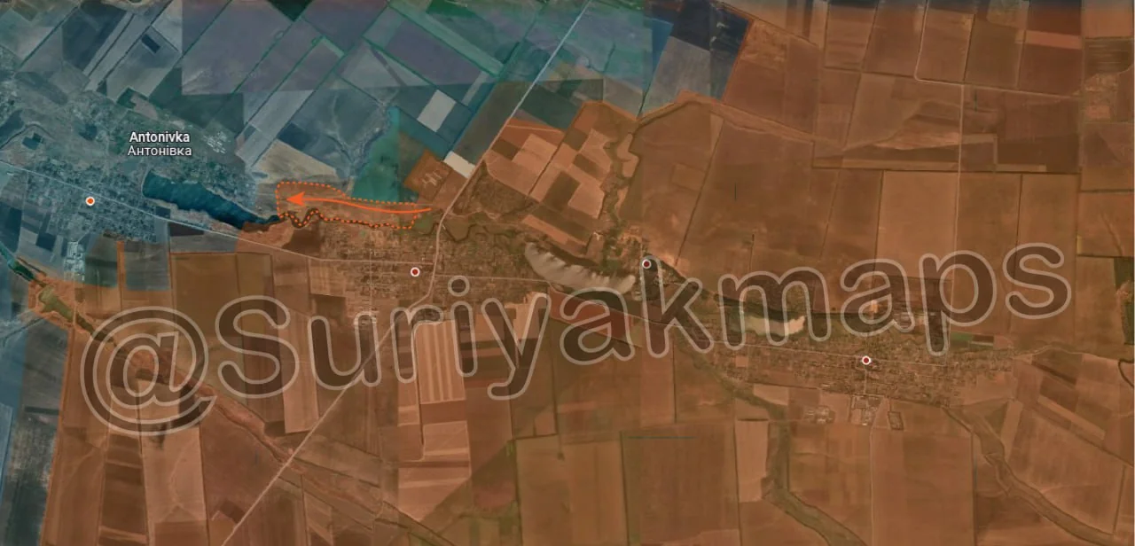
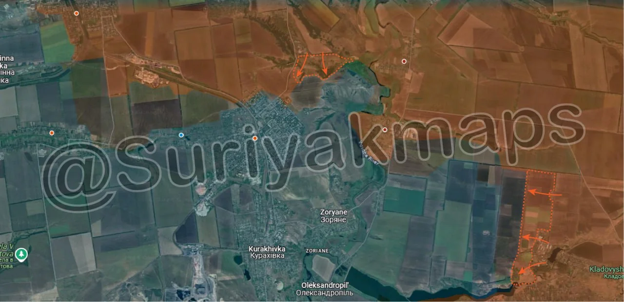
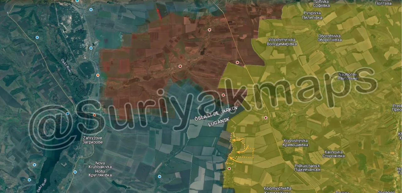
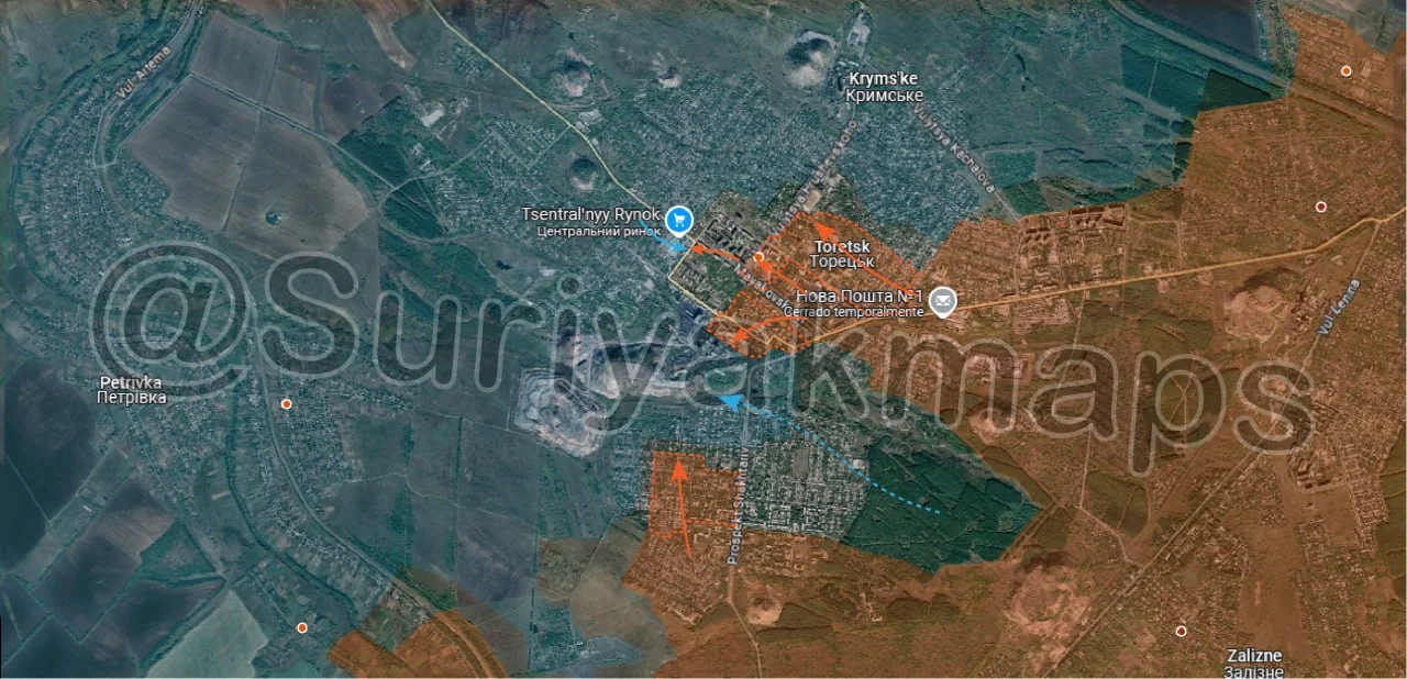
On the Toretsk front, over the past few days the situation has deteriorated quickly for Ukraine, as Russia has advanced in several areas. In the centre of the town, Russian troops pushed further into the suburbs north of the main apartment area, capturing several streets and the university area. Additionally, Russian assault groups in the apartment block area have pushed southwest towards the mine complex, capturing several of the outer buildings. Over on the south side, Russian troops in the south of the town, who had been someone inactive since capturing that area 2.5 weeks ago, begin their assaults once again, pushing north and capturing multiple residential blocks.

The advance in the industrial area and southern suburbs has forced Ukraine to abandon most of the area they controlled in the southern forests, as they were at risk of being encircled, with only a few roads left through the slag heaps and out the west side of the town. If you’ve been paying attention to my analysis, you’ll know I predicted this exact scenario occurring 3 weeks ago, including Ukraine’s decision to abandon this area once Russia reached the mine complex. Suriyak has a large part of the abandoned area as greyzone, as he is once again being conservative until we get more confirmation Russia has actually moved in (spoiler; will be in next update).

As for what actually caused this sudden spike in advances in Toretsk, its currently unclear. From Ukrainian sources the usage of FABs is not particularly high, due to how close Russian and Ukrainian troops are operating to each other, and there has also not been much usage of armoured vehicles. From what I can gather, Ukraine’s lack of manpower, and particularly infantry, has really started to kick in in Toretsk, as after several months of fighting on this front they are attritioned enough that they can no longer properly man the front, leaving gaps for Russia to slip through. I’ll note this is similar to what happened in Novohrodivka on the Pokrovsk front, however Ukraine had too few troops there when the battle began, whilst here it has taken some time to reach that point. Russia is not nearly as affected due to its having more frequent rotations and fewer issues with reinforcements.
Ukrainian Forces Advance: 1.20 km²

Advance = 1.20km2

Following on from Picture 9, Russian troops advanced south into Sofivka, capturing the village. This was not exactly unexpected, as it is quite a small settlement (single road, only 600m long), and Ukraine has been pulling back to their positions on the other side of the Vovcha River. At this stage most of Ukraine’s troops have retreated from the pocket on the eastern side, and now occupy the defence line along the River. Russia will still take a few days to properly clear the remaining area and move in.