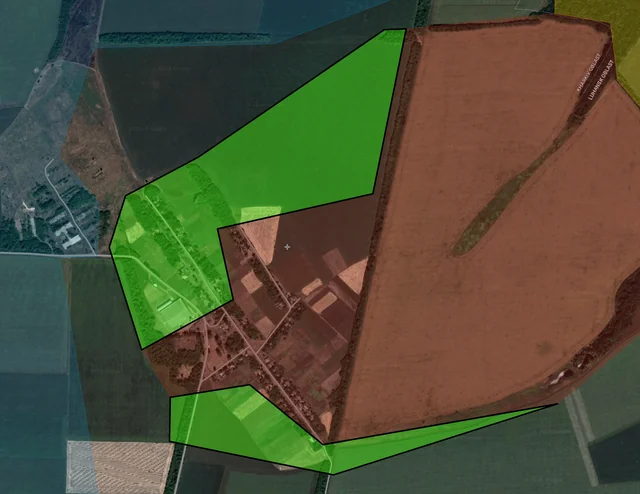
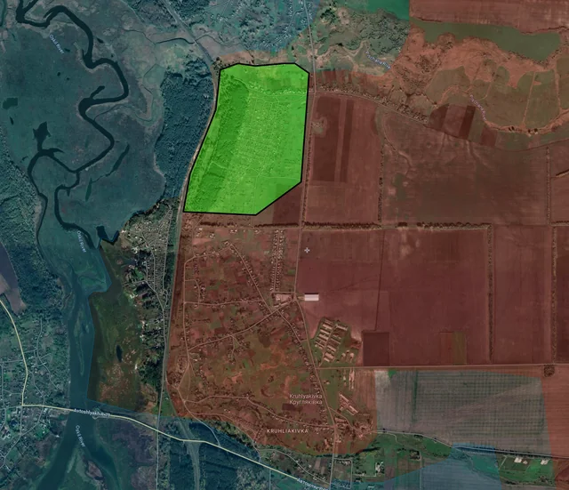
Back home
Post #117

RU POV: Russian advances from Day 969 and 970 of the War - Suriyakmaps

Oct 20, 2024 — Oct 21, 2024 War Day 969–970

A few days ago a number of Russian sources reported that the regrouping of their units on the Selydove and Kurakhove fronts (which has been going on for the past month) had been completed, and significant operations were about to begin. I think its important for me to start this post off with that information, as it’ll provide some context to a lot of the updates you’re about to see. Whilst Russian troops never stopped trying to advance in these areas, as of the start of Day 969 Russian operations there spiked significantly, and a number of large scale bombardments and assaults began.

-----------------------------------------------------------------------------------------------------------------

Pictures 1 to 3 are from Day 969 (Sunday 20 October), and pictures 4 to 10 are from Day 970 (Monday 21 October).

-----------------------------------------------------------------------------------------------------------------

A reminder that these maps are confirming updates from previous days (i.e. 12 to 48 hours delayed from each day).

Ukrainian Advance
0.00 km²
Overall (set): 0.00 km²
Russian Advance
41.65 km²
Net Change
-41.65 km²

Situation Snapshots

Imagery, commentary, and territorial changes from the period.

13 entries
Russian Forces Advance: 1.72 km²

Advance = 1.72km2

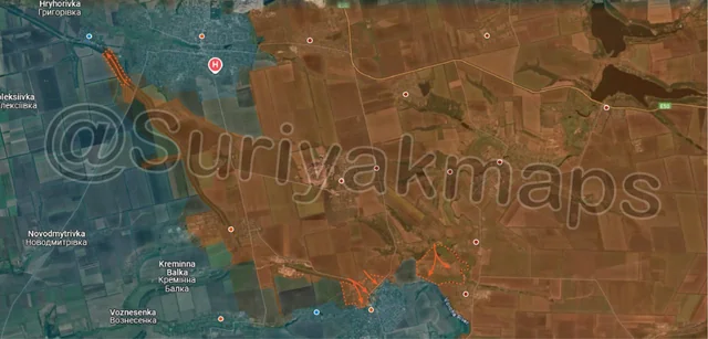
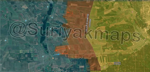
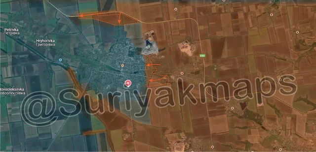
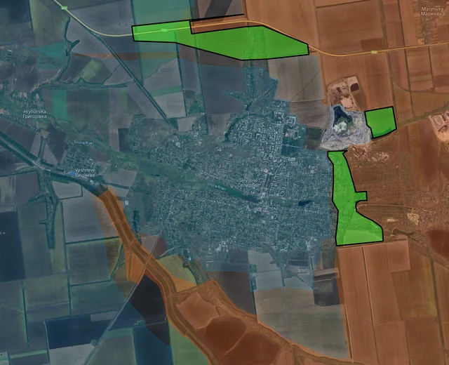
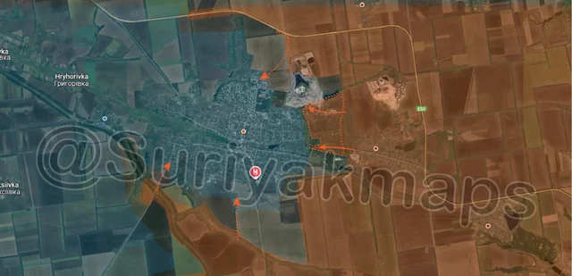
Starting off with the Selydove front, and specifically the city itself, Russian command has finally pulled the trigger on the assault on Selydove, after semi-encircling the city over the past few weeks. Attacks were launched in the morning on all sides of the city, with at least one larger advance on the east side being confirmed, recapturing the mine and suburbs they lost a week ago. Ukrainian troops in the city are in an incredibly difficult position, having to defend multiple different areas whilst also being heavily restricted in supplies (described here).

The Ukrainian units in the city, the 15th National Guard and 117th Mechanised Brigades, and the Tsunami Regiment (National Police/Assault regiment) are under immense pressure, and are unlikely to be able to hold the city against this level of assault. Whilst they currently still have a way out, their exit route is getting smaller every day, and if they leave it too late to evacuate, they will take enormous casualties. If this sounds familiar, its because this is almost identical to what happened in Vuhledar several weeks ago, which I spoke about at length in the weeks leading up loss of the town, although Selydove would be on a much larger scale.
Russian Forces Advance: 3.14 km²

Top Left Advance = 0.44km2, Bottom Middle Advance = 0.93km2, Bottom Right Advance = 1.77km2

ollowing on from Picture 1 (later that same day), Russian assault groups were confirmed to have advanced along the railway line up to the outskirts of Vyshneve (top blue dot) where clashes are taking place. If Ukraine losses control of Vyshneve, they will have no way of leaving the city on the south side of the city/river, leaving their only escape/supply route to the northwest, which is also under threat.

To the south, Russian forces launched a new series of attacks on Hirnyk, capturing most of the northern suburbs of the town, as well as capturing the dense Ukrainian trench network on the hill to the northeast. This network was well constructed, with several underground sections and bunkers, which Ukraine has been successfully holding for over a month now. The loss of this trench network and hill opens the way for further Russian assaults into eastern Hirnyk, as well as towards Zoryane (off map south).
Russian Forces Advance: 2.49 km²

Top Advance = 0.69km2, Bottom Advance = 1.80km2

Over on the Kurakhove front (south of the above), Russian troops built off their previous progress in and around Maksymilianivka, capturing more of the fields on the southwest side of the town (with some losses), as well as pushing along the main road into eastern Kurakhove, establishing a foothold in the first street. Thus the battle for the key logistics hub/fortress of Kurakhove has officially begun, although as I explained a few days ago, the real battle won’t begin until Russia reaches the main part of the town. These eastern streets have few small buildings, and are somewhat separated from the rest of Kurakhove.

Ukraine is not really manning/defending this area, due to how poor these positions are, and is instead holding the large trench network and eastern suburb buildings about 1.2km west of this advance. The benefit of these dachas is that they provide Russian troops with a level of cover (both small buildings and trees) as they advance towards Kurakhove, instead of having 2km of open fields to cross.
Russian Forces Advance: 6.21 km²

Advance = 6.21km2

Following on from Picture 2, over the past 2 days, at the same time as the attacks on Hirnyk, a different set of Russian assaults groups crossed the Vovcha River, capturing most of Zoryane, as well as the surrounding fields. This puts Ukrainian troops on this front in an incredibly awkward position, as their their primary defence line (the Vovcha River line) has been breached, and they’re also quickly losing positions to Russian assault into northern Hirnyk. If Ukraine cannot stabilise within the next day or 2, then the entire Hirnyk/Kurakhivka area is likely to collapse, resulting in a retreat west to Berestky (just off map bottom left). This is without needing to completely cut the supply lines to this area, which is what Russia has been trying to do for about a month now.
Russian Forces Advance: 1.87 km²

Top Left Advance = 1.03km2, Upper Bottom Middle Advance = 0.63km2, Lower Bottom Middle Advance = 0.21km2

Top Left Advance = 1.03km2, Upper Bottom Middle Advance = 0.63km2, Lower Bottom Middle Advance = 0.21km2
Context
Continuing on from their advances in the previous post, Russian assault groups in Kruhlyakivka continued clearing the settlement, capturing the northern streets up to the river. Its unlikely they will try attack Kolisnykivka from this side, due to the Pischana River making crossing into the town more difficult, and so will likely instead head south to clear the remainder of the town before attacking Zahryzove.
Context
To the southeast, over several days of fighting Russian assault groups have established control over most of Vyshneve, leaving only a couple of old warehouses before they fully control the village. Clashes are currently taking place over these warehouses, as well as reports that Russian troops had already moved south along the road and are also trying to assault Pershotravneve. For now this section of road has been marked greyzone, as its unclear what the result of this Russian assault was.
Russian Forces Advance: 5.14 km²

Top Advance = 1.58km2, Bottom Advance = 3.56km2

Further south on the Oskil River front, Russian troops captured another field east of Novosadove, straightening the frontline.

Over in Torske (red dot below r), over the past 4 days Russian assault groups have been launching attacks, managing to make some progress in reaching the outskirts of the small town. They have however failed to take up positions in the buildings or farm area, despite several attempts, as Ukrainian defenders held them off. This area (east of Torske) has seen a lot of back and forth over the last year and a half, trading hands every few months. We will have to wait and see if this latest Russian attempt will bear any fruit, or end up like all the other tries.
Russian Forces Advance: 1.16 km²

Advance = 1.16km2

Over in Niu-York, Russian troops made a small advance northwest of the town, capturing another field and treeline. These small advances around Niu-York are opportunistic, rather than part of any concerted Russian effort to reach the villages to the west.
Russian Forces Advance: 3.34 km²

Top Advance = 1.86km2, Middle Advance = 0.32km2, Bottom Advance = 1.16km2

Following on from Picture 2, on the second day of Russia’s large-scale assault of Selydove, Russian assault groups were confirmed to have made more progress in several areas, capturing most of the eastern suburbs on both the north and south side of the river within the city itself, as well as advancing along the E50 highway west, getting within 500m of cutting the last supply route out of the city. In the latter advance Russian troops also entered the northern residential area, taking positions in the first few houses.

Context
Whilst the quick Russian assaults on the east side of the city are of great concern for the Ukrainian troops in the town, the northern advance is the biggest threat, as if Russia pushes just a little further, they will cut off the city from supply, dooming the defenders. There would still be a way out if that happens, through the fields towards Hryhorivka, but that is across open ground, likely to be muddy, and will inevitably leave them exposed to Russian drones and artillery. I would have recommended that Ukraine should have pulled its units out of the city by this point, however given their track record of staying too long in Urban battles, I suspect the order will not be given until it is too late.
Russian Forces Advance: 3.81 km²

Top Advance = 3.53km2, Bottom Advance = 0.28km2

Following on from Picture 4, Russian assault groups have continued making progress around Hirnyk, capturing most of the eastern fields and approaching the eastern outskirts of the town. The situation is deteriorating rapidly for the Ukrainian garrison, as now they are having to defend from attacks from the east, on top of the northern assaults they were already dealing with. Whilst its unlikely their units will be encircled like Selydove, Ukraine should still try retreat now to avoid being overwhelmed/overrun in urban combat.

To the south, Russian troops also made another small advance in the eastern dachas of Kurakhove, capturing another section.
Russian Forces Advance: 12.77 km²

Middle Right Advance = 5.41km2, Lower Middle Advance = 6.01km2, Bottom Left Advance = 1.35km2

Further south on the Kurkahove front/Vuhledar front, Russian units have made multiple large advances across the board. Starting in the north, Russia finally cleared the remainder of the small pocket and Ukrainian trenches along the O0532 highway, giving them full control over it. Russia now has a direct supply route from Donetsk city, through Kostyantynivka, and down past Vuhledar, which will help simplify Russian logistics on this front, although they will need to push Ukraine back another 3-4 km before they can start thinking about using this road for that purpose.

To the south, in Katerynivka (red dot below y), Russian assault groups have continued making progress, capturing the remainder of the eastern half of the town. As I explained in my previous post, once Russian troops reach and establish a foothold in a town/city, their progress tends to speed up, resulting in the settlements falling faster than it takes them to reach it in the first place. This looks to be holding true for Katerynivka, with over half the town now under Russian control, and Ukraine only holding onto to small residential buildings now, the battle may conclude by the end of the week.

Adjacent to this, Russian troops also advanced across a wide front south of the Solodka River, closing in on Yelyzavetivka.

Out west, Russia also made another small advance towards Bohoyavlenka, now within 2.4km of the town. There is however a large trench network between Russia and the settlement, which will have to be overcome before they can think of beginning assaults.