Back home
Post #119

RU POV: Russian advances from Day 972 of the War - Suriyakmaps

Oct 23, 2024 — Oct 23, 2024 War Day 972–972

Pictures 1 to 6 are from Day 972 (Wednesday 23 October).

-------------------------------------------------------------------------------------------------------

A reminder that these maps are confirming updates from previous days (i.e. 12 to 48 hours delayed from each day).

Ukrainian Advance
0.00 km²
Overall (set): 0.00 km²
Russian Advance
30.44 km²
Net Change
-30.44 km²

Situation Snapshots

Imagery, commentary, and territorial changes from the period.

7 entries
Russian Forces Advance: 6.64 km²

Top Advance = 0.67km2, Bottom Advance = 5.97km2

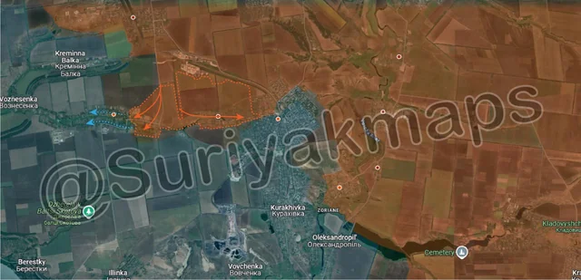
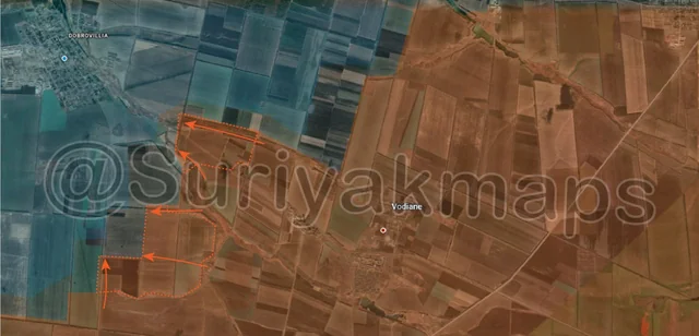
Starting with the Selydove front, in the early hours of Day 972 Russian troops made several advances west of the railway line, capturing multiple fields, several trenches and the last part of the poultry farm near Tsukuryne (bottom red dot). This was done by different units to the ones assaulting Selydove, but is part of the same overall operation. As you can see from the map, this greatly widens the Russian flank here, and will make it easier for Russia to reinforce and supply its troops operating in Tsukuryne and the west side of Selydove.

There were also some reports that the first Russian recon group had reached Novodmytrivka (just off map bottom left), however this could not be confirmed yet. That is however one of the most likely targets for further attacks by Russian troops in this area, so expect to see further updates around there in the next few days.
Russian Forces Advance: 0.75 km²

Advance = 0.75km2

On the Kupyansk front, Russian forces made a minor advance west of Kyslivka (red dot below r), capturing a small trench system along the main road.
Russian Forces Advance: 1.14 km²

Left Advance = 0.18km2, Right Advance = 0.96km2

Following on from Picture 1, Russian assault groups continued pressing in from all sides in Selydove. From the information that could be confirmed (as of late Day 972), Russian troops had pushed through to central Selydove, capturing most of the large apartment buildings on the south side (Video 1, Video 2), as well as capturing the small industrial yard in eastern Vyshneve (left red dot). The latter means Russia has now physically cut that exit route, meaning Ukraine can only try escape from the fields to the northwest.
Context
Whilst Suriyak is being cautious/conservative as usual, and has only marked the advances that could be confirmed, he has still recognised that Ukraine’s defence of the city has broken, and has expanded the greyzone quite a bit.

Whilst reports and evidence of what is specifically going on in Selydove are scattered/sparse, what can be said is that Ukraine’s lines have effectively broken, and there is no coordinated defence of the city. Having had limited/little supply for about 2 weeks now, lacking infantry, and being attacked from all sides, Ukrainian troops simply could not hold the lines, and are now either trying to flee the city or are getting stuck having to hold their positions. Current estimates from both Ukrainian and Russian sources suggest the city will probably fall within 3 days.

Russian Forces Advance: 5.43 km²

Advance = 5.43km2

urther south of the previous picture, over the past few days Russian infantry groups have had success in Izmailivka (red dot above i) and Novoselydivka (red dot above S), capturing the entirety of the former, and the eastern side of the latter. Izmailivka fell due to Russian advances into northern Hirnyk essentially pinning Ukrainian defenders between attacks on opposite sides, forcing them to retreat. Fighting is ongoing in Novoselydivka, with Ukraine retreating to the west side of the village.

With these advances, Ukraine is now down to a single supply route for all its forces in the settlements along the Vovcha River here, which is 2.75km away from current Russian positions. It is actually within ATGM range, however Izmailivka not having any tall buildings, plus the terrain in this area mean Russian troops in the village do not actually have line of sight on the road just yet. It is however well within drone and artillery range, so Ukrainian troops in this area will begin to have serious supply issues over the coming days/weeks. In all likelihood this entire area will fall to Russia by the end of November at the latest.
Russian Forces Advance: 4.96 km²

Top Advance = 1.70km2, Bottom Advance = 3.26km2

On the Vuhledar front, Russian assault groups made a series of advances towards Bohoyavlenka (blue dot), capturing multiple fields and several trenches. From the reports and videos this looks to have been done quite easily, with Ukraine pulling back to the larger trench networks around the town itself, in order to conserve its limited manpower here. Notably there is a lack of artillery usage by Ukrainian troops, likely due to shortages, although drones are still being used in large numbers.
Russian Forces Advance: 11.52 km²

Top Left Advance = 3.56km2, Top Right Advance = 1.23km2, Middle Left Advance = 6.73km2

Following on from their advances on the Zaporizhzhia front last week, Russian troops have continued their attacks in the fields around Levadne (red dot above u), capturing many of them and several Ukrainian trenches. Like I mentioned in that previous, for now Russia is only advancing up to the stream that runs north of Levadne. They’ve also started to head northwest towards Olhivske (red dot far left side), likely to try reach it and capture the area up the previously mentioned stream.

At this time these attacks are quite small in scale, with neither side having all that many troops in this area (compared to other fronts), so it wouldn’t be correct to call this an offensive. The possibility still remains that Russia will launch a Zaporizhzhia Offensive at some point in the future, with increasing mentions in both Ukrainian and Russian media.

There was also a small advance to the east, with Russia capturing another field west of Staromaiorske in an opportunistic attack.