Back home
Post #126

RU POV: Russian and Ukrainian advances from Day 986 to 989 of the War - Suriyakmaps

Nov 6, 2024 — Nov 9, 2024 War Day 986–989

Pictures 1 and 4 are from Day 986 (Wednesday 6 November), pictures 5 to 8 are from Day 987 (Thursday 7 November), pictures 9 to 13 are from Day 988 (Friday 8 November), and pictures 14 to 17 are from Day 989 (Saturday 9 November).

-------------------------------------------------------------------------------------------------------

A reminder that these maps are confirming updates from previous days (i.e. 12 to 48 hours delayed from each day).

Ukrainian Advance
4.27 km²
Overall (set): 4.27 km²
Russian Advance
81.54 km²
Net Change
-77.27 km²

Situation Snapshots

Imagery, commentary, and territorial changes from the period.

17 entries
Russian Forces Advance: 1.59 km²

Advance = 1.59km2

Kicking off today’s post with the Kupyansk front, Russian forces made more progress in Kolisnykivka using small squads of infantry, now controlling most of the village. The large forest area on the west side still presents a challenge in being able to properly secure the settlement, but once that area has been cleared Russia can continue moving north into Hlushkivka.

Russian Forces Advance: 3.63 km²

Advance = 3.63km2

In conjunction with the recapture of Ivano-Darivka mentioned in the previous post, Russia has also moved back along the railway and recaptured Vyimka (a long abandoned village). Russia was forced to abandon this area about a month ago, so we will have to wait and see if they can hold onto it this time. As a reminder, the railway line here leads directly to Siversk (top of map, no icon), which is the main hub for Ukrainian military activity on this front.
Russian Forces Advance: 6.35 km²

Advance = 6.35km2

On the Selydove front, having captured most of Novodmytrivka (bottom dot), and fighting for control of Novooleksiivka (under the r), Russian troops straightened the front line between those villages by attacking west via the treelines, capturing a number of fields. Ukraine will likely lose control of the remainder of Novodmytrivka and Novooleksiivka within the next day or 2, as they simply do not have the forces or strong enough defences to hold both settlements.
Russian Forces Advance: 1.23 km²

Advance = 1.23km2

Heading south, on the Kurakhove front, Russian assaults groups have continued their mechanised attacks in Antonivka, capturing most of the town. Ukraine is still trying to hold onto its positions on the western side of the settlement, but Russian strikes and fire support from neighbouring Katerynivka are making it difficult for them.
Russian Forces Advance: 2.50 km²

Top Advance = 2.16km2, Bottom Advance = 0.34km2

Following on from Picture 3, Russian troops pressed the attack in Novooleksiivka, capturing the village. Ukrainian troops have pulled back into nearby Yuriivka, which will be the next target for Russian assaults.

To the south, Russia captured the last small section of Novodmytrivka, confirming full control over the village after a few weeks of fighting. Similar to the above, surviving Ukrainian troops pulled back to the next nearest village (in this case Zorya), and will attempt to hold the line there. Unlike Novodmytrivka, the battle for Zorya is unlikely to go for much longer than a few days, as its much smaller than Novodmytrivka, and has poor connection to Ukrainian supply lines (no road on west side).
Russian Forces Advance: 3.72 km²

Advance = 3.72km2

A little further south on the same front, Russian troops continued their success along the banks of the Kurakhivske Reservoir, taking part of the hills and establishing a foothold in northern Illinka. Ukraine has some forces in this village attempting to hold it, but for the most part they are contesting this area with numerous drones launched from Kurakhove (bottom of map). Ukraine has concentrated a significant number of drone teams in Kurakhove, hiding amongst the many buildings, as they try to hold the town against threats on multiple sides.
Russian Forces Advance: 2.84 km²

Middle Left Advance = 0.90km2, Bottom Advance = 1.94km2

On the Vuhledar front, on the west side Russia expanded the buffer around Maksymivka slightly, capturing a field as they prepare to continue their push north. To the southwest, Russian troops also captured a few more fields south of Yelyzavetivka, as they close in on the town from multiple sides.
Russian Forces Advance: 1.79 km²

Advance = 1.79km2

On the Zaporizhia front, Russian troops made another small opportunistic advance northeast of Nesteryanka, capturing some treelines. Like the previous advance in this area, these are being done with only small groups of soldiers, and not part of any larger offensive.
Ukrainian Forces Advance: 4.27 km²

Advance = 4.27km2

In Kursk, on the north side of the front Ukraine has been counterattacking into Novoivanovka with tanks and IFVs for over 2 weeks now, in an attempt to drive Russia back, and has finally had some success, recapturing some of the eastern side of the village. Heavy clashes are currently ongoing for the centre of the village however, as well as to the southwest in Darino.

On the southern side of the front, Russian troops began their assault of Plekhovo, entering the village from the southern side. The outcome of these attacks is currently unknown.
Russian Forces Advance: 1.09 km²

Advance = 1.09km2

South of Chasiv Yar, Russian troops captured the mine and surrounding area, helping to secure their southern flank and providing them good line of sight over the southern fields.
Russian Forces Advance: 1.40 km²

Advance = 1.40km2

On eastern side of the Pokrovsk front, Russian troops slightly expanded the buffer around Novooleksandrivka, capturing 1 of the long treelines that has been in the greyzone for several months.
Russian Forces Advance: 11.53 km²

Top Advance = 3.91km2, Bottom Advance = 7.62km2

Following on from Picture 5, starting with the north side Russian troops quickly took over southern Hryhorivka, after flanking the village in an advance along the railway as I mentioned in the previous post. At the same time they also pushed west through the fields towards Yuriivka, now only 1.4km away from the village.

To the south, Russian forces launched multiple mechanised assaults following their capture of Novodmytrivka (below y) the previous day, capturing multiple fields north and south of the village, as well as reaching the outskirts of Zorya. There were also reports of Russia reaching Sontsivka and establishing a foothold in the small town, but as of this update it was not yet confirmed. Due to the Strashnyi River restricted supplies, these Russian advances have also forces Ukraine to pull out from the fields between Zorya and Sontsivka, which are now in the greyzone.
Russian Forces Advance: 4.89 km²

Top Advance = 2.00km2, Bottom Advance = 2.89km2

Following on from Picture 7, on the north side Russian troops made a small advance in the fields east of Kurakhove, capturing a few of them and the treelines near the main road. They are also now right outside the outermost layer of Kurakhove’s defences, right next to one of the anti-tank ditches and behind that one of the large trench networks. Pushing into those defences from the west would be very difficult, so they are more likely to advance behind it using the treelines to the north as cover.

To the south, outside of Bohoyavlenka Russian assault groups began to advance north, capturing several fields and treelines, as they begin to close in on Trudove (below the S). As a reminder, Trudove is the last settlement before Uspenivka, which sits on an important intersection of many main roads. Once fighting begins in Uspenivka using said roads for transport of supplies becomes impossible, which will threaten the entire Ukrainian force to the east of the village.
Russian Forces Advance: 11.76 km²

Advance = 11.76km2

Heading back to Kursk, Russian troops launched a large mechanised assault on the northern side of the front, breaking through the Ukrainian defenders and capturing the 3 villages of Pogrevki, Marevka and Orlovka. There were also reports they had made it even further south, re-entering Novaya Sorochina, but that could not be confirmed at this time.

Compared to the recent Ukrainian counterattacks in Novoivanovka, counterattacking in this area is significantly more difficult due to the forest cover, Malaya Loknya River and several small streams

Russian Forces Advance: 4.56 km²

Advance = 4.59km2

On the Oskil River front, Russia made a small advance north of Vyshneve, capturing several fields just west of the Kharkiv/Luhansk border. There are also clashes ongoing to the south, on the outskirts of Pershotravneve.
Russian Forces Advance: 6.66 km²

Top Advance = 1.05km2, Bottom Advance = 5.61km2

Once again on the Selydove/Kurakhove front, following on from Picture 12, on the north side Russian troops repeated their actions from the previous day in Hryhorivka, and have pushed into and captured the southern side of Petrivka. This puts Ukraine in quite the awkward spot, as the northern side of both those villages, which they are currently defending, is supplied via a road on the far western side, right next to Russian positions. Their saving grace is the Solona River which splits the north and south side of Hryhorivka and Petrivka, however if Russia is able to cross they will lose both villages very quickly.

To the south, following on from their progress from the previous day, Russian assault groups continued their attacks towards Sontsivka, and were confirmed to have established a foothold on the northern side of the town. Heavy clashes are currently ongoing in the town, with Ukraine bringing in a tank to shell buildings as they struggle to drive Russia out. Ukraine is losing control of the settlement, and will likely have to pull its forces back to the southern side across the Solona River, which will help them buy time. If Russia captures Sontsivka, there are no more settlements between them and Stari Terny, which as I’ve mentioned numerous times is critical for Ukraine’s supply of not only their forces north of the reservoir, but also Kurakhove itself.
Russian Forces Advance: 16.00 km²

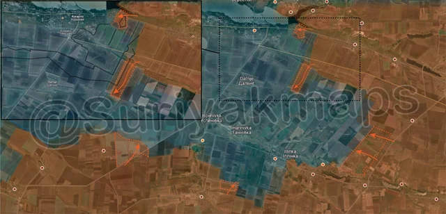
Top Advance = 0.48km2, Middle Advance = 1.71km2, Bottom Left Advance = 4.50km2, Bottom Middle Advance = 1.07km2, Bottom Right Advance = 8.24km2

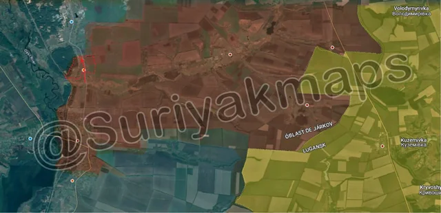
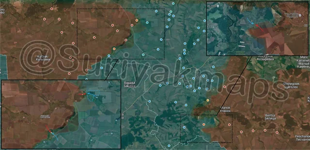
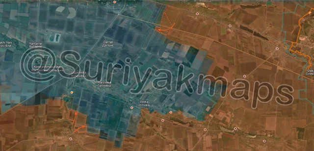
On the Kurkahove and Vuhledar fronts again, with some very interesting developments. Starting with the north side, Russian forces broke into the eastern side of Kurakhove (proper), capturing the first group of buildings as well as the large trench network on the eastern side. Russian command look determined to begin an assault of the town now, rather than wait for it to be cut off by Russian advances elsewhere.

A little further south, Russian troops launched an attack over the stream to the southwest, reaching the road east of Dalnje and capturing the 2 treelines. This attack was very clever, as it cuts the (dirt) supply road for Ukrainian forces in the fields to the east, which will hasten Russia’s capture of the area. Russian troops here are also protected from counterattack, as they have done this right next to Ukraine’s own defences, with Ukraine’s anti-tank ditch now protecting the Russian flank and making it significantly more difficult for Ukraine to counterattack.

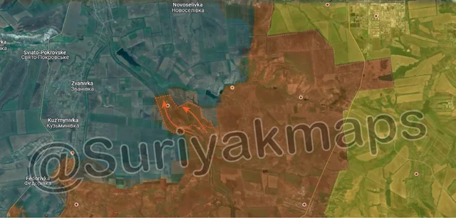
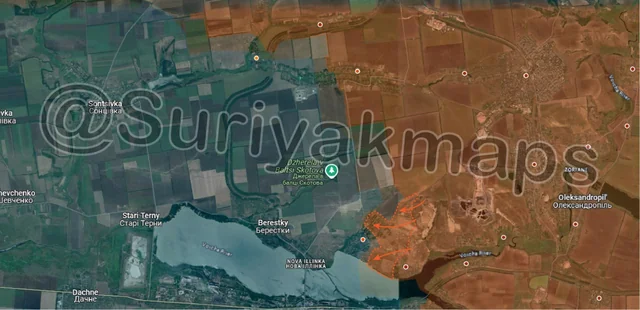
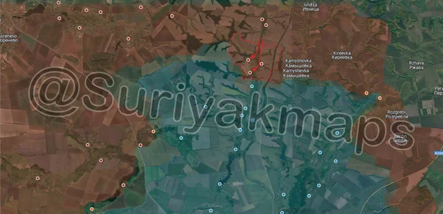
Southwest, Russian forces straightened the frontline north of Kostyantynivka, following Russian advances in Antonivka mentioned in Picture 4.

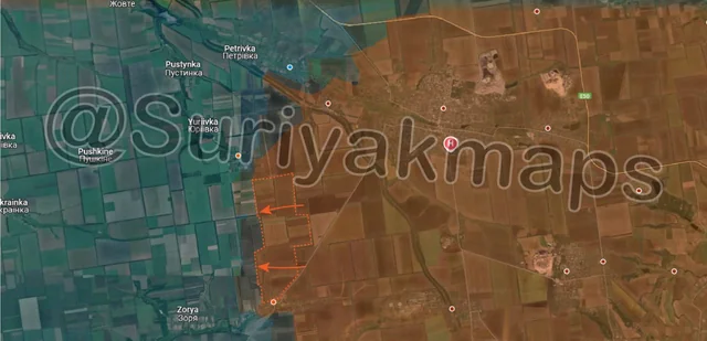
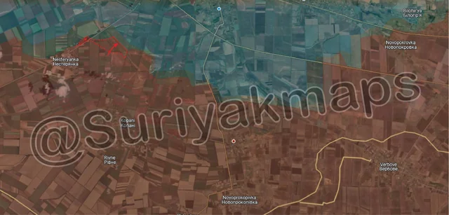
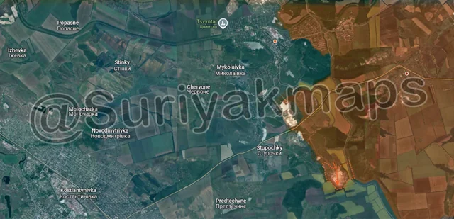
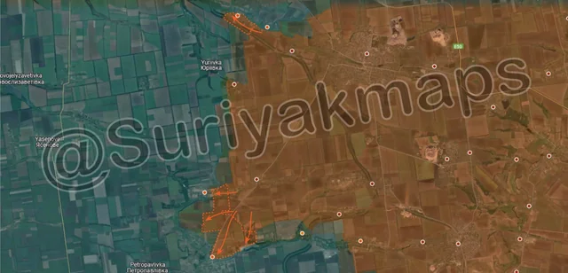
To the west, Russia made another mechanised attack out of Bohoyavlenka, capturing another field and reaching the southern side of the large tree plantation. If Russia can establish a solid position in the area, they will be able to use the dense cover of the plantation to advance all the way up to the Sukhi Yaly River, and cut off Yelyzavetivka.

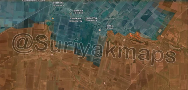
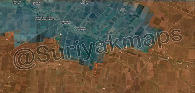
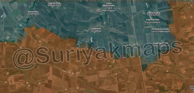
Heading west again, Russia also continued pressing forward east of Maksymivka, capturing multiple fields. They are now just 3.3km from Kostiantynopolske (under the zoomed in map), with there only being 1 treeline inbetween their current positions and the village.