Back home
Post #130

RU POV: Russian and Ukrainian advances from Day 999 and 1000 of the War - Suriyakmaps

Nov 18, 2024 — Nov 19, 2024 War Day 999–1000

Fewer map updates for this post, not because there isn’t anything happening, but because there is a lot of intense fighting in many different areas with a lack of geolocatable footage meaning territorial changes can’t be confirmed.

This meant I had more time to whip up some statistics for Day 1000 of the war, which will be at the bottom of the post.

-------------------------------------------------------------------------------------------------------

Pictures 1 to 4 are from Day 999 (Monday 18 November), and pictures 5 to 7 are from Day 1000 (Tuesday 19 November).

-------------------------------------------------------------------------------------------------------

A reminder that these maps are confirming updates from previous days (i.e. 12 to 48 hours delayed from each day).

Ukrainian Advance
6.07 km²
Overall (set): 6.07 km²
Russian Advance
42.05 km²
Net Change
-35.98 km²

Situation Snapshots

Imagery, commentary, and territorial changes from the period.

8 entries
Russian Forces Advance: 11.30 km²

Top Advance = 11.30km2

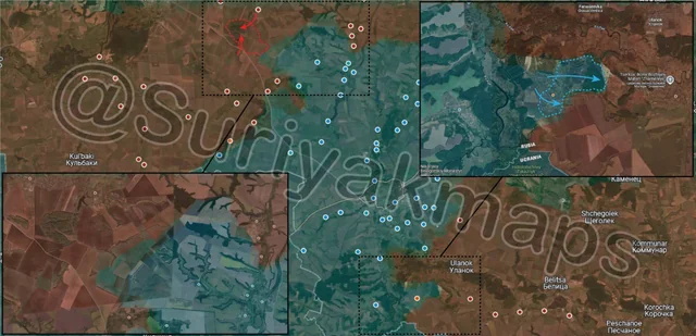
We start off this update on the Kursk front, where intense clashes continue on both the north and south side. In the north, Russia closed the encirclement/pocket that had formed in the forest southeast of Olgovka. For a quick recap, about 5 days ago some footage was released showing that Ukraine was still present in said forest, almost certainly survivors from the retreat from Olgovka several weeks prior. These soldiers were trapped in the forest, with Russia having fire control over the fields and main road out of the area, and Ukrainian attempts to break them out were defeated. These Ukrainian soldiers have been bombed and droned for a while now, and from several field reports and Suriyak’s own assessment, they have all either been captured, killed, or managed to flee through the fields in the night, with Russia taking control of the forest. I can’t comment much further on this one, as there is just a lack of information and footage about what happened.

To the south, Ukraine counterattacked in Plekhovo, recapturing most of the village, and reentering the forest area on the east side. This has partially undone Russian progress over the past week, but they are still in a precarious situation due to Russian positions to the north along the Psel River.
Russian Forces Advance: 3.43 km²

Middle Right Advance = 2.00km2, Bottom Advance = 1.43km2

On the Selydove front, Russia continues to gradually expand from the city, capturing another field to the north, as well as several fields on the west side. The latter advance also has Russia closing in on the village of Pustyanka, which is unlikely to hold long once assaults begin (which should be within the next 2 days).
Russian Forces Advance: 20.12 km²

Left Advance = 2.86km2, Right Advance = 6.15km2, Bottom Advance = 11.11km2

On the Kurakhove front, Russian forces continued to squeeze the Ukrainian pocket along the Sukhi Yaly River. On top of capturing a large area of fields on the north side, they’ve also advanced along a broad front to the south, entering Yelyzavetivka (below the m), and moving further through Trudove (under the i). Ukraine is already in the process of retreating from this area, but many troops are still stuck inside the pocket trying to slowly withdraw without being overrun (as they can’t all just up and leave at the same time).

A little to the west, Russia also captured the fields on the north side of the main road to Uspenivka. This means there is just 1 open field between Russian positions and Kostiantynopolske, which as I’ve mentioned previously is likely their target before they head to Uspenivka. Whilst the village does have several large warehouses and a couple of larger buildings, the lack of any defences and how small it is mean it will be quite difficult for Ukraine to hold against Russian assault.
Russian Forces Advance: 2.32 km²

Advance = 2.32km2

Heading west, on the Velyka Novosilka front (and the edge of the Kurakhove front), Russian troops made a small advance towards the village of Rozdolne, just south of the large Ukrainian ditch in the area (dark blue). As I’ve discussed previously, capturing Rozdolne will allow Russia to take control of the northeast supply road to Velyka Novosilka, which is the main route for supply for the town (but not the only one).
Russian Forces Advance: 1.60 km²

Advance = 1.60km2

On the Kupyansk front, Russian assault groups cleared the forest on the west side of Kolisnykivka, and entered the village of Zhyvotivka. As I mentioned in an earlier post, Russia had to clear the forest area first before they could move north, as leaving it was too risky due to the chance Ukraine could sneak through and counterattack the Russian flank. With the forest secured the Russian flank here is secured by the Oskil River, which would be difficult to cross in this area (banks of the river are dense shrubs/reeds and quite waterlogged, limiting movement).
Russian Forces Advance: 0.23 km²

Advance = 0.23km2

In Toretsk, the back and forth continues, with a few Russian assault troops making it further into the northern suburbs, capturing the sports field and surrounding houses. It will be quite difficult to hold this area, but if Russia can then in addition to their advances on the northern outskirts (the bit up top above the m), they may be able to slowly envelop and clear the northern side of Toretsk. The only problem with this is the high likelihood of Ukrainian counterattacks, and the mine complex in Krymske being difficult to assault.
Russian Forces Advance: 3.05 km²

Advance = 3.05km2

Following on from picture 3, Russian troops advanced once again north of Illinka, closing in on the village. With Ukraine already retreating from here, the village will likely be captured quite quickly once assaults begin.
Ukrainian Forces Advance: 6.07 km²

Bottom Advance = 6.07km2