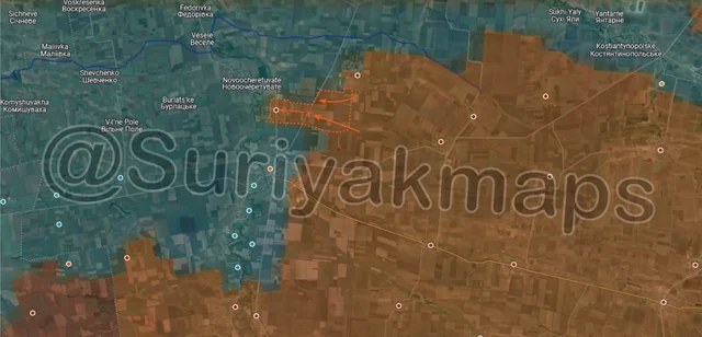
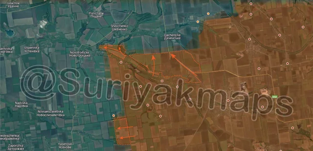
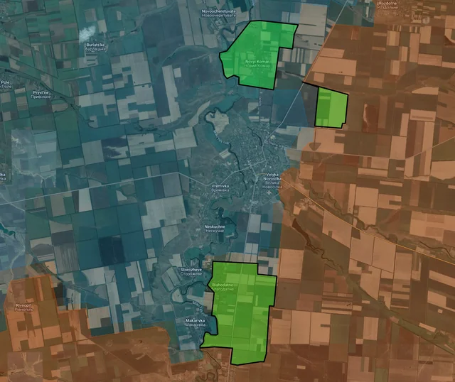
Back home
Post #135

RU POV: Russian and Ukrainian advances from Day 1012 to 1016 of the War - Suriyakmaps Maps

Dec 1, 2024 — Dec 5, 2024 War Day 1012–1016

I’ve been extremely busy this week, so this territorial changes post is later than it usually would be. I chose to prioritise getting the November statistics posts out rather than this post, and I’m hoping to have more time next week so the gap between posts is shorter.

-------------------------------------------------------------------------------------------------------

Pictures 1 to 3 are from Day 1012 (Sunday 1 December), pictures 4 to 7 are from Day 1013 (Monday 2 December), pictures 8 to 12 are from Day 1014 (Tuesday 3 December), pictures 13 to 16 are from Day 1015 (Wednesday 4 December), and pictures 17 to 19 are from Day 1016 (Thursday 5 December).

-------------------------------------------------------------------------------------------------------

A reminder that these maps are confirming updates from previous days (i.e. 12 to 48 hours delayed from each day).

Ukrainian Advance
3.58 km²
Overall (set): 9.02 km²
Russian Advance
93.06 km²
Net Change
-89.48 km²

Situation Snapshots

Imagery, commentary, and territorial changes from the period.

20 entries
Russian Forces Advance: 3.41 km²

Advance = 3.41km2

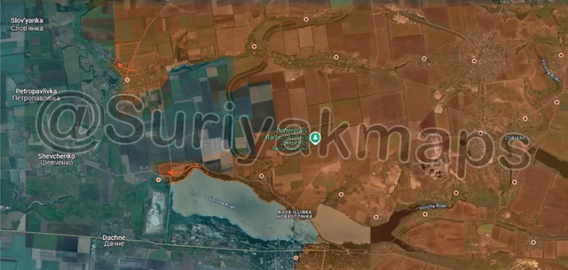
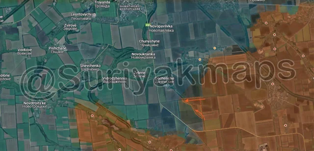
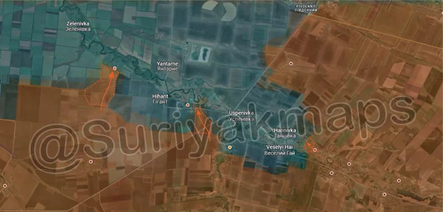
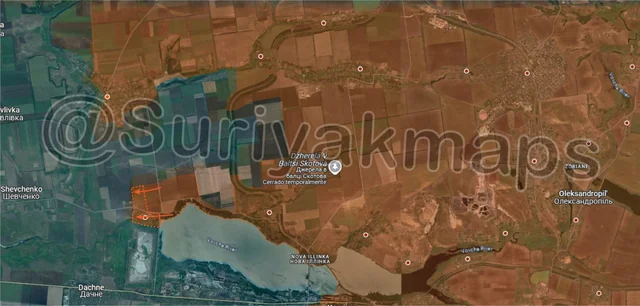
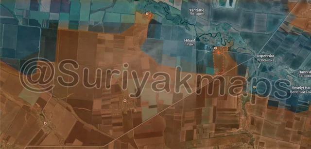
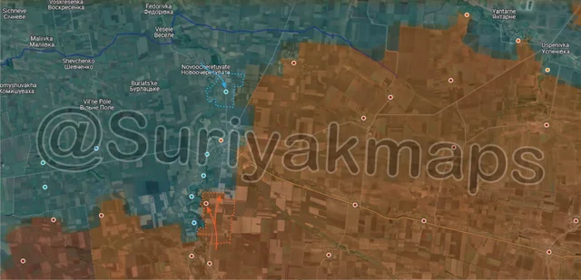
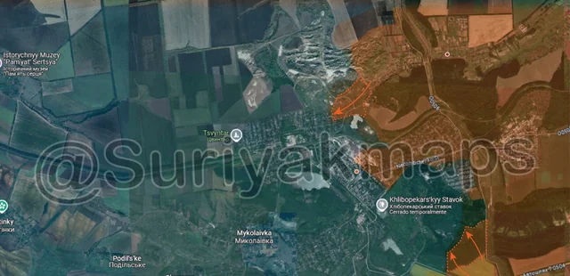
We kick off this post on the familiar Oskil River front, where Russia has continued slowly advancing in the central area heading south, capturing a couple of fields. This northern section of the Oskil River front has significantly calmed down compared to a month ago, with it mostly being smaller clashes and a couple of individual assault squads trying to capture a position every few days (as well as the usual drone warefare).
Russian Forces Advance: 1.58 km²

Top Advance = 0.81km2, Bottom Advance = 0.77km2

Heading down to the Kurakhove front, on the north side Russian troops captured more of the northwestern part of Sontsivka. Ukraine is still regularly counterattacking and reinforcing their remaining positions there, as they try to avoid losing their hold on the eastern side of the Solona River.

To the south, continuing on from the clashes mentioned in the previous post, Russian troops were confirmed to have been successful in the first assaults on Stari Terny, and have captured the eastern houses (along the shore of the reservoir), as well as partially flanking the village through the field to the north.
Russian Forces Advance: 12.96 km²

Advance = 12.96km2

North of Velyka Novosilka, a sudden Russian mechanised assault from the east caught Ukrainian troops off-guard, and managed to push deep into Ukrainian lines and occupy the village of Novyi Komar within hours. This physically cuts not only the northeastern road (although it was already under Russian fire control), but also the northern road through Novocheretuvate, which leaves Ukraine with just 1 road to supply the town via (west side).

Ukraine does not look to have manned Novyi Komar at all, nor several of the trenches east of the village, allowing Russia to easily push in and capture it. This almost certainly occurred due to Ukrainian manpower shortages, with many of their troops pulled back to Velyka Novosilka itself to defend from the Russian attacks currently occurring. The main problem for Russia will be properly securing this area, as it is quite exposed and a decent way from their existing positions around Rozdolne.
Russian Forces Advance: 16.62 km²

Top Advance = 15.10km2, Bottom Advance = 1.52km2

Following on from Picture 1, Russian assault groups continued making progress in the central area, capturing more fields to the north, northeast, and southwest of Lozova (red dot below k). Ukraine has heavily dug into the village, or rather the small, dense forested areas in and around the settlement, which provide good cover from Russian drones and artillery. These may become irrelevant however if Russia continues pushing from that northern side, as Lozova could easily be cut off if they are not careful.
Russian Forces Advance: 0.62 km²

Advance = 0.62km2

In Torestk, Russian assault groups continued to clear the southern suburbs of the town, capturing a large portion of the remaining area (many houses and small apartment buildings). A few Russian recon troops were also seen moving through the slag heaps towards the western side of Toretsk, although were not successful in setting up a foothold. The slag heaps themselves have not been occupied by Ukraine for months at this point (due to being too exposed), but just house random bits of communications and surveillance equipment. It will be quite difficult for Russia to push through this little canyon between the slag heaps, however them controlling the houses next to it prevent Ukraine from using this path to reinforce their troops in the southern suburbs as well.
Russian Forces Advance: 1.06 km²

Advance = 1.06km2

Northwest of Selydove, Russia has continued slow pushing though the fields around the E50 highway, capturing a couple more treelines southeast of Dachenske. Ukraine has continually tried to contest and counterattack this southern area, but is being forced back to the chain of settlements along the Solonyi River (Dachenske, Zelene, Vidrozhennia, etc).
Russian Forces Advance: 3.36 km²

Top Left Advance = 1.14km2, Upper Left Advance = 0.16km2, Bottom Advance = 2.06km2 (yes, these are all actually connected)

Following on from Picture 2, Russian assault groups expanded their control of the fields north of Stari Terny (as they were not occupied by Ukraine) and a small section of the railway north of Beretsky. Ukraine is still fighting for Stari Terny, but given how small the village is, and the awkward gap between there and Ukrainian positions in Shevchenko (1 road with no treelines on either side, essentially completely exposed), its proving very difficult for them.

In Kurakhove, Russian assault groups made more progress in the centre of the town, capturing more apartment buildings as they force Ukraine back west. They also cleared out the last of the trenches and fields on the east side of the road heading south from Kurakhove, which had mostly been abandoned by this point (still takes time due to being cautious of mines, traps and isolated Ukrainian soldiers).
Russian Forces Advance: 0.25 km²

Advance = 0.25km2

In Chasiv Yar, after several weeks of back and forth clashes over the refractary plant, Russian assault groups have finally been confirmed to have gained a foothold on the southern side, as well as the adjacent trenches. This area has been heavily bombarded for months, but due to the sheer strength of the Soviet Industrial buildings this part of the town still has a lot of cover and many buildings/facilities still standing. For an idea of what it looks like, see 0:38 in this video, and 0:24 in this video (both are a bit dated, but provide the best overview of the area).

The refractory plant is key to Chasiv Yar, as its capture would provide Russia a strong position with which to begin assaults into the central apartment building area, and the rest of the town. The clashes over the past few weeks here have actually involved relatively few soldiers, but constant fighting of small groups and an enormous amount of drones, artillery and FABs used by both sides. The battle for Chasiv Yar is far from over, but we are now entering a critical phase for control of the central town (the most heavily fortified and built up part).
Russian Forces Advance: 21.38 km²

Top Left Advance = 2.32km2, Top Right Advance = 15.23km2, Bottom Advance = 3.83km2

Following on from picture 6, Russian forces have clared the majority of fields northwest of Selydove, now closing in on Dachenske, Zelene and Vidrodzhennia across a wide front (no horizontal treelines left between Russia and these villages). Do not expect assaults to begin on these in the short term however, as other nearby advances will occupy much of Russia’s attention.

This being the Russian moveout to the west of the above advance. Russian troops have pushed along the railway as well as the treelines along the main road, and have captured multiple fields and treelines north of Novopustynka (no dot, its slightly below the leftmost arrow). This advance puts them within striking distance of Shevchenko, as well as possibly cutting of Novopustynka from the north. Shevchenko is important as it’s a small town directly south of Pokrovsk, and could act as a forward base for the eventual assaults on the city and surrounding areas. Capturing Shevchenko also means getting behind the string of settlements along the Solonyi River (Vidrodzhennia, Zelene, and Dachenske), skipping the need for Russia to try breach that defence line.

Further south, Russia also captured some of the fields south of Pushkine. The actual control of Pushkine is hard to determine, as neither side has made any clear reports on the small village in a little while, but this should be cleared up soon.
Russian Forces Advance: 4.84 km²

Left Advance = 3.18km2, Middle Advance = 1.23km2, Right Advance = 0.43km2

On the southern side of the Kurakhove front, Russian forces launched 2 simultaneous mechanised assaults towards the settlements along the Sukhi Yaly River. Starting with the west side, which was the main push, Russian vehicles reached Sukhi Yaly, dropping off soldiers who captured the first row of houses on the south side. Heavy clashes are currently occurring as Russia seeks to quickly expand their control, whilst Ukrainian troops desperately try to dislodge them before more Russian reinforcements arrive.

To the east, a separate Russian group reached Kostiantynopolske, dropping troops off on the eastern side who captured the first few houses. Similar to the above, clashes are ongoing as Russia tries to expand their control and Ukraine is attempting to drive them out. Even if Ukraine is successful here, Russian capture of Sukhi Yaly would spell the end of Ukrainian control of Kostiantynopolske anyway, as it leaves just 1 bridge south of Yantarne as a viable exit/supply route (which could be destroyed at any time).

Further east, Russian forces captured the last couple of houses of Romanivka, as well as an adjacent trench network.
Russian Forces Advance: 2.03 km²

Advance = 2.03km2

Back to the Velyka Novosilka front, this time the southwest side. After a few weeks of clashes Russia has taken control over Novodarivka and the fields immediately south of the village. The settlement itself was mostly irrelevant to the battle, as most of the few buildings there have been completely destroyed, but there are a number of dugouts and small trenches amongst the trees that had to be gradually cleared for Russia to take Novodarivka.
Ukrainian Forces Advance: 1.75 km²

Advance = 1.75km2

Over to the Kupyansk front, Ukraine has driven Russia out from the small bridgehead they had on the opposite side of the Oskil River (discussed last post), as well as recapturing the adjacent greyzone. The southern bridgehead still stands, however like this northern one it will be difficult for Russia to hold it due to the difficulty in supplying and reinforcing the other side of the river.
Ukrainian Forces Advance: 1.83 km²

Top Advance = 1.01km2, Bottom Advance = 0.82km2

Following on from picture 9, Russian troops quickly captured Novopustynka, having just reached the settlement the previous day. Ukrainian troops in this particular area (150th Strike Recon Battalion and 151st Mech) are severely understrength and exhausted, having been driven out of (and taken losses in) 7 villages on this front in the past month alone. The lack of any prebuilt defences has made their defence of these small villages functionally impossible, and they’ve essentially spent a whole month retreating into a village, trying to set up positions, being forced out days later, before repeating the process again. Russia is exploiting this weakness, but will run into other Ukrainian units and actual defences as/if they start heading north.

Some forward Russian troops have already started heading north, and have had the first clashes on the southwestern side of Shevchenko. It will not be easy to take the town, but if Ukraine has not prepared for its defence they could make progress quite quickly.

Further south, some Ukrainian troops counterattacked from the small forest area and reentered western Zorya, taking over the houses there.
Russian Forces Advance: 0.68 km²

Advance = 0.68km2

Following on from picture 7, Russian assault groups have captured Stary Terny, as well as the last section of the shoreline on the north side of the reservoir. Not only does this advance put Ukrainian forces in the fields north of here at risk of being encircled (only 1 exit route via Shevchenko), but it also provides Russia a direct line of site onto Kurakhove’s main supply road through Dachne (those lithium mines are lower in elevation than the surrounding area). Russia will still need to set up positions in Stary Terny, such as ATGM crews, before they can try establish fire control over the road.
Russian Forces Advance: 1.14 km²

Top Advance = 0.13km2, Middle Right Advance = 1.01km2

Following on from picture 10, results of the clashes in both Sukhi Yaly and Kostiantynopolske have been confirmed. Starting with the former, Russian troops successfully pushed further into Sukhi Yaly, capturing most of the eastern side of the village. Ukraine only controls a small sliver of the settlement now, and will almost certainly be forced/wiped out in the next day or 2.

A similar situation is unfolding in Kostiantynopolske, with Russian also capturing the eastern side of this village, as well as most of the central area. Ukraine will be forced/wiped out of the village in the next day or 2 here as well. Once these villages fall, these troops will likely capture the fields between them and move onto Yantarne, as well as pushing down the river to the northwest.
Russian Forces Advance: 19.00 km²

Top Left Advance = 6.45km2, Top Right Advance = 2.11km2, Bottom Advance = 10.44km2

Context
Following on from picture 3, Ukrainian troops counterattacked in Novyi Komar with a mix of Armoured cars, APCs and some tanks, driving Russian troops out of the village before they could consolidate positions. Russia is currently striking at these Ukrainian troops, and will likely make another attempt on Novyi Komar in the coming days (although will be more difficult now that it is manned). I’ll note that some Russian sources claim Russia still has some sort of presence in Novyi Komar, although I can’t confirm this.

A little east of here, Russia captured some of the fields east of the main road.

To the south, Russian forces made large gains through the fields on the south side, capturing many Ukrainian trenches, dugouts and the village of Blahodatne, as Ukraine continues to bring soldiers back into Velyka Novosilka for the defence of the town. As I mentioned in the previous post, we may soon see Russian assaults on Velyka Novosilka from the south, on top of the east and southeastern assaults already occurring. This advance also jeopardises Ukrainian positions on the west side of the Mokri Yaly River, as Russia could cross north of Ukraine’s positions around Makarivka and cut them off.
Russian Forces Advance: 0.87 km²

Top Advance = 0.43km2, Bottom Right Advance = 0.44km2

Following on from picture 8, whilst battles continue over the refractory plant, a separate group of Russian troops has pushed up the hill from Kalinina and entered the northwestern suburbs. Whilst this was only a small group, it opens up yet another angle for Russia to try capture Chasiv Yar.

There was also a small Russian push into the southern forest area, as they continue to try clear it of Ukrainian troops. This area has held out so long due to the sheer number of small dugouts and trenches, as well as a large bunker complex hidden in the forest (which Russia dropped a ballistic missile on a few weeks ago). It will still take quite some time for Russia to push through here, but its necessary if they want to take Chasiv Yar.
Russian Forces Advance: 0.31 km²

Top Advance = 0.23km2, Bottom Advance = 0.08km2

Following on from Picture 5, Russian forces in central Toretsk recaptured most of the central apartment buildings, after continued clashes over the past few weeks. Despite intense bombardment by both sides, most of these buildings remain standing and provide strong positions that are key for control of Toretsk.

A little south, Russian assault groups also entered the Shakhta Centralnaya mine, one of 2 Ukrainian strongholds in Toretsk. The strong industrial buildings of the mine complex house a decent portion of Ukraine’s forces in this part of the town, and its loss would allow Russia to secure central Toretsk and begin moving into the western suburbs. Given Ukraine was also reported to have blown the central ventilation shaft of this mine, which would indicate they are losing control and are trying to reduce its usefulness if captured by Russia.
Russian Forces Advance: 2.95 km²

Advance = 2.95km2

Following on from picture 15, a Russian assault group has advanced from the north towards Uspenivka, taking up positions in the northeastern warehouses. This advance puts Ukrainian troops in Hannivka and Veselyi Hai in a difficult position, as losing Uspenivka would mean being encircled. Whilst Ukraine began to pull out of this southern pocket starting 2 weeks ago, they still have many troops trapped inside, and regularly send in tanks for fire support and individual vehicles as they try to evacuate them. Whilst some are evacuated, others are not so lucky and end up trapped, forced to hold their dugouts/trenches/basements to the end.