Back home
Post #136

RU POV: Russian and Ukrainian advances from Day 1017 to 1019 of the War - Suriyakmaps Maps

Dec 6, 2024 — Dec 8, 2024 War Day 1017–1019

Another very busy week for me so a larger gap than average between my posts. I know that Day 1020 updates are out, but due to Reddit’s post picture limit (20), that will go in my next post.

-------------------------------------------------------------------------------------------------------

Pictures 1 to 6 are from Day 1017 (Friday 6 December), pictures 7 to 11 are from Day 1018 (Saturday 7 December), and pictures 12 to 17 are from Day 1019 (Sunday 8 December).

-------------------------------------------------------------------------------------------------------

A reminder that these maps are confirming updates from previous days (i.e. 12 to 48 hours delayed from each day).

Ukrainian Advance
1.59 km²
Overall (set): 1.59 km²
Russian Advance
84.72 km²
Net Change
-83.13 km²

Situation Snapshots

Imagery, commentary, and territorial changes from the period.

18 entries
Russian Forces Advance: 3.44 km²

Advance = 3.44km2

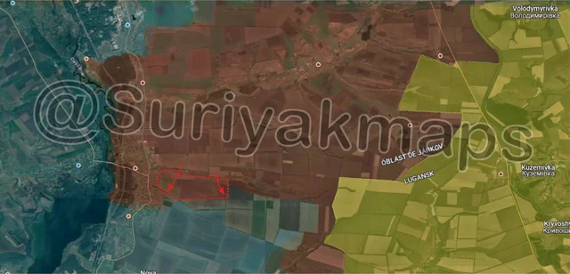
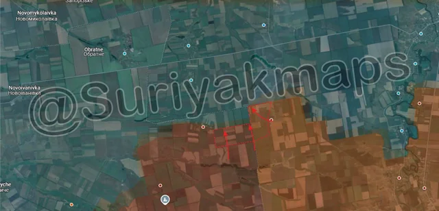
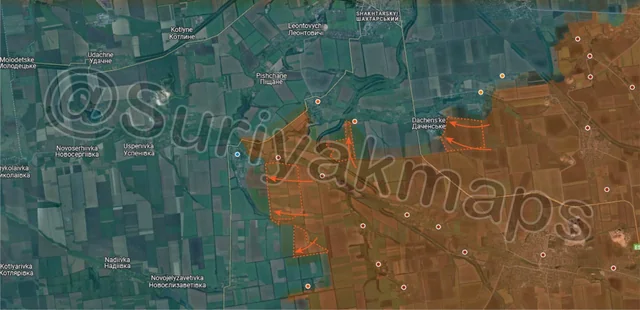
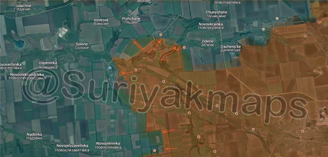
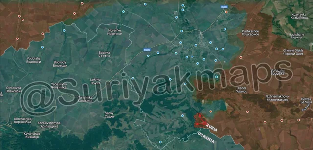
We begin with Kursk, where we finally have some updates on the southern part of the front after a few weeks (last change Day 999) of clashes. Russian assault groups have continued to press the attack on the southern flank, along the border, whilst Ukrainian troops were defend central Plekhovo and the foreszt to the east. They were able to successfully advance and push into the forest area along the Psel River, flanking the village.

Ukraine supplies and reinforces its troops on the east side of the river via pontoon bridges, which are now under threat with this advance. Ukraine’s control of Plekhovo will not last if they cannot restore control of their flanks.
Russian Forces Advance: 3.45 km²

Advance = 3.45km2

On the Oskil River front, Russia has continued pressing forward from this north side, capturing another couple of fields east of Kruhlyakivka, as the gradually straighten the front line.
Russian Forces Advance: 1.88 km²

Left Advance = 1.55km2, Right Advance = 0.33km2

In Toretsk, heavy clashes continue in the central area of the town, as Ukraine struggles to maintain its last positions in the apartment blocks and Valyuga mine complex. Last update I mentioned that travelling between those slag heaps would be difficult due to how narrow and exposed the area is, but successfully making it through would help Russia begin to crack the western part of the town and hinder reinforcements to the southern side. From videos and reports, it looks like Russian command have decided to take the risk and have sent small groups of infantry through that gap, which are engaging Ukrainian troops in the western houses.

To the south, Russia recaptured part of the last little bit of forest just south of Toretsk, and is currently fighting with Ukraine around the small slag heap. Once this area falls its unlikely Ukraine will be able to hold onto the last streets of the southern suburbs they still hold.

Further west, Russian troops also made an advance through one of the fields near Leonidivka, using the treelines as cover.
Russian Forces Advance: 5.77 km²

Top Advance = 3.52km2, Bottom Advance = 2.25km2

On the Pokrovsk/Selydove front, Russian forces have taken advantage of weak Ukrainian lines to continue pushing advances on the north side of the Solonyi River. I mentioned last update that taking Shevchenko would not be easy unless Ukraine was not prepared for its defence, which looks to have come true. Russian assault groups have already entered the town and captured the first street, and are now pushing deeper into the central area. Ukraine looks to have completely neglected/not considered the defence of Shevchenko, as only a few smaller groups of soldiers are reportedly present with some drone support, which is not nearly enough to hold the town.

Adjacent to this, a separate group of Russian troops has captured the fields along the main road and has pushed west into the forest area opposite Novotroitske. This delays reinforcements from Pokrovsk (who now have to travel further around via Uspenivka to the west), as well as providing Russia another angle to attack Novotroitske from (north). Similar to Shevchenko, Ukraine does not look to have nearly enough troops to properly defend this small town, although one key difference is that they likely used to have more but lost them in trying to counterattack Novopustynka (red dot east of Novotroitske). This advance also saw Russia capture a large trench network (between Novotroitske and Novopustynka) within a matter of hours, highlighting just how bad the current situation is for Ukraine.

Further south, Russia also advanced through the fields near one of the small streams, as Ukraine struggles to even contest this area.
Russian Forces Advance: 5.61 km²

Advance = 5.61km2

On the southern Kurakhove front, continuing from the last update, Russia cleared the last section of Sukhi Yaly (as I mentioned), granting full control over the village. With the village captured Russia has also been able to advance through the fields to the east, heading for the crossing to Yantarne (Hihant is just 3 farm buildings).
Russian Forces Advance: 5.24 km²

Advance = 5.24km2

On the Velyka Novosilka front, Russian troops captured the fields between Rivnopil and Novodarivka, as it became untenable for Ukraine to maintain its positions there. They’ll continue to advance north across a broad front (from the i to m) towards the road between Velyka Novosilka and Novoivanivka.
Russian Forces Advance: 16.64 km²

Bottom Advance = 16.64km2

Following on from picture 1, in northern Kursk Ukrainian counterattacks have finally allowed them to re-enter Pogrebki from the west, with some Ukrainian infantry digging in in the warehouses on southwest side of the village. Russia is currently trying to bomb them out, so further Ukrainian progress here will be dependent on being able to successful move from the warehouses into the streets of the village and being reinforced by more troops.

To the south, over the past few days Russia was confirmed to have pushed into Plekhovo from the north and south (the flank mentioned in picture 1), recapturing the remainder of the village and driving Ukraine out. They were so successful in this that they were able to chase the surviving Ukrainian forces up to the Psel River, and even managed to cross and gain a foothold in the forest on the other side.

The battle for Plekhovo started over 2 months ago (around Day 948), with a lot of back and forth over control of the eastern side of the village, as well as Ukraine reinforcing the area several times. Whilst crossing the Psel River back in the first week of Ukraine’s Kursk offensive was questionable, I can’t fault them for continuing to throw troops and equipment into Plekhovo’s defence, as its loss now exposes the southern Ukrainian flank and one of their key supply roads. Russia has already managed to cross the Psel River and the fighting for Guevo has begun (on the eastern outskirts). If Russia captures Guevo, they will be able to push north through the forested area and directly threaten the southern Ukrainian supply route, something I described several times over the past few months.
Russian Forces Advance: 12.72 km²

Advance = 12.72km2

On the Oskil River front again, this time a little further south where Russian assault groups captured a large area of fields as they pushed west. They are currently only slightly northwest of Zelenyi Hai (red dot below m), which will likely be their next target, although some Russian troops will continue west whilst that assault begins.
Russian Forces Advance: 0.75 km²

Advance = 0.75km2

Following on from picture 3, Russia was successful in their assault of the first buildings of the western suburbs, and has captured the first few streets north of the slage heap, as well as some of the buildings of the Valyuga mine complex. With Ukraine reportedly destroying several of the taller mine structures as they retreat to prevent Russian control, its likely that Ukrainian units are unable to hold onto this area and are being forced to withdraw to the northwest. This advance also gives Russia control over the larger slag heap, however as mentioned previously there are no actual positions on top of the heap as it is simply far too exposed.
Russian Forces Advance: 11.29 km²

Top Left Advance = 1.46km2, Top Right Advance = 3.34km2, Middle Left Advance = 4.79km2, Lower Left Advance = 1.30km2, Bottom Left Advance = 0.40km2

Following on from Picture 4, starting with the west side, Russian troops have continued advances through the fields south of Novopustynka, once again capturing a large area and many positions due to Ukraine just not having the forces present to contest the advance. Russia has also been remotely mining part of this area, including Novotroitske (under the r and i), as the situation continues to deteriorate for Ukraine.

Northeast of these, Russian troops advanced up one of the treelines and entered the outskirts of Vidrodzhennia, as the first assault on the village begins. This particular settlement was always going to be difficult for Ukraine to hold, owing to it being on the opposite side of the Solonyi River, and not having any realy defence (just one long ditch on the south side, no trenches).

Further east, a Russian mechanised group pushed through the fields and landed troops on the outskirts of Dachenske. Clashes are currently ongoing here, and it will be quite difficult for Russia to move into the village due to the large number of drones and artillery present.
Russian Forces Advance: 6.96 km²

Advance = 6.96km2

Following on from picture 6, Russian forces advanced east from Rivnopil, capturing many fields as they head towards the Mokri Yaly River. Russian advances on the other side of the river (discussed last post), put Ukraine in a very awkward position here, as both Makarivka and Storozheve (blue dots under s), are now quite exposed and have had their defences (facing south) flanked.

Ukrainian troops here will be forced to retreat in the coming days to avoid being encircled against the river, however that also means Russia would be close to the western side of Velyka Novosilka, and to the main road that heads west from the town. Ukraine is already struggling with Russian advances on the east side, and the soon to begin assaults from the south, so adding yet another angle of attack would further overwhelm Ukraine and lead to the town falling even faster than it currently is.
Russian Forces Advance: 0.39 km²

Advance = 0.39km2

In Chasiv Yar, continuing from their advances in the previous post, Russia cleared the last of the Ukrainian positions north of the industrial area (including some trenches and dugouts), and made some a little more progress in the northwestern suburbs. Heavy clashes are still ongoing in the industrial area, but with Russia moving into the adjacent residential area Ukraine is gradually losing control of the centre of Chasiv Yar, which will essentially spell the end for their control of the town if lost.

Russian Forces Advance: 0.19 km²

Advance = 0.19km2

Following on from picture 9, Russian troops were confirmed to have captured the last of the central highrise buildings in Toretsk. If they can hold onto this area, the capture of the mine (southwest of this advance) and the remainder of the central town area is only a matter of time.
Russian Forces Advance: 4.22 km²

Top Left Advance = 0.20km2, Top Right Advance = 2.86km2, Middle Left Advance = 0.40km2, Bottom Advance = 0.76km2

Following on from picture 10, Russia once again made some advance around Novopustynka, moving west and capturing the first streets of Novotroitske (above the r). From reports from both sides, the small town is unlikely to last long, with Ukraine simply unable to gather enough troops to mount a proper defence, especially given they do not have any defences set up around the settlement.

To the northwest, as mentioned in picture 4, Russian assault groups have been making quick work in Shevchenko, and have captured the southwestern side of the town, as well as the fields along the railway. At the current rate, the town will fall within the next day or 2, with minimal forces having been involved. Ukraine should have been prepared for this, given the town is only a few km south of Pokrovsk, but has been preoccupied with counterattacking Russia around Novohrodivka (off right side of map), and with the clashes around Dachenske and Lisivka.

To the south, Russia also advanced one field west, towards Pushkine. There is still a lack of confirmable information from either side about the status of the village.
Russian Forces Advance: 1.83 km²

Advance = 1.83km2

North of Beretsky, Russia captured some more fields previously abandoned by Ukraine.
Russian Forces Advance: 1.00 km²

Top Advance = 0.37km2, Bottom Advance = 0.63km2

South of the previous image, in Kurakhove itself Russian troops have made further progress in the town, entering the southern apartment building area next to the main road, and capturing the first few. There have been some Russian reports that Ukraine has begun to abandon Kurakhove due to losses and failure to control the centre of the town, retreating west to the power plant, but I cannot confirm this just yet.

Further south, Russia slightly expanded its control of the main road near Dalnje. No other real movement in this area for the past week or so, with the focus being on fighting elsewhere.
Russian Forces Advance: 3.34 km²

Advance = 3.34km2

South of Velyka Novosilka, Russian troops advanced up several more fields after Ukraine was forced to pull its troops back into the town to help defend. Russia is now on the outskirts on the southern side, in addition to the foothold they already have on the east side, so we will likely see an assault attempt here in the coming days as Russia continues to pressure the town.

One benefit for Ukraine is that the southern side of Velyka Novosilka is quite small and separated due to the Shaitanka and Mokri Yaly Rivers, so if they begin to lose control they can blow the bridges to slow Russian advances from this side. It wouldn’t completely stop them however as Russia has access to the central town area due to their eastern foothold, and the Shaitanka River is thin enough in some sections that it can be crossed on foot.
Ukrainian Forces Advance: 1.59 km²

Top Advance = 1.59km2,