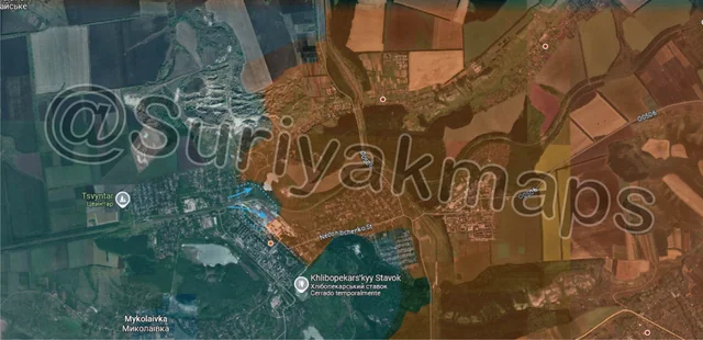
Back home
Post #138

RU POV: Russian and Ukrainian advances from Day 1024 to 1026 of the War - Suriyakmaps

Dec 13, 2024 — Dec 15, 2024 War Day 1024–1026

Pictures 1 to 8 are from Day 1024 (Friday 13 December), pictures 9 to 14 are from Day 1025 (Saturday 14 December), and pictures 15 to 19 are from Day 1026 (Sunday 15 December).

-------------------------------------------------------------------------------------------------------

A reminder that these maps are confirming updates from previous days (i.e. 12 to 48 hours delayed from each day).

Ukrainian Advance
6.61 km²
Overall (set): 6.99 km²
Russian Advance
68.98 km²
Net Change
-62.37 km²

Situation Snapshots

Imagery, commentary, and territorial changes from the period.

19 entries
Russian Forces Advance: 6.70 km²

Advance = 6.70km2

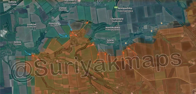
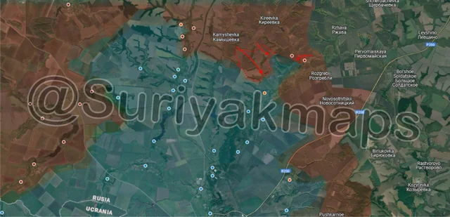
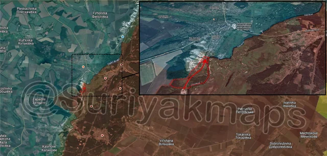
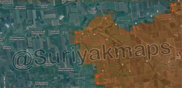
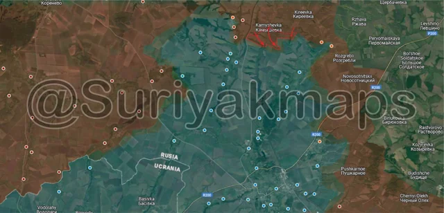
Third times a charm starting the update with Kursk. This time we’re on the northern side of the front, where over the past few days Russia has captured some of the fields and forest areas south and east of Kamyshevka. This is part of Russia’s gradual push towards Malaya Loknya (above the a) and Russkoe Porecnhoe (above the m) from the north, keeping pressure on that side of the Kursk front in addition to the battles ongoing on the west and southern sides.

This area has had far less attention from both sides due to the terrain (lots of little forests and small streams) making usage of large forces difficult. Most battles here involve 1 to 3 vehicles carrying infantry assaulting across the fields, or groups of infantry working their way through the forests to attack dugouts/trenches.
Ukrainian Forces Advance: 0.33 km²

Advance = 0.33km2

Speak of the devil and he shall appear. In the previous post I mentioned Ukraine would likely counterattack the refractory plant within the next day or 2 (at the time), which has now occurred. Ukrainian infantry have broken back into the plant and some of the houses of the northern suburb of Chasiv Yar, undoing Russia’s progress from yesterday. Fighting for control of the refractory plant will continue for a while to come, as its control is critical for Russia to capture/Ukraine to hold Chasiv Yar.
Russian Forces Advance: 0.12 km²

Left Advance = 0.07km2, Right Advance = 0.05km2

In Toretsk, Russian troops continued making progress, capturing the central market (mentioned last post), meaning they control all of the centre of the town. They also made a smaller advance on the north side, recapturing the substation buildings.

As I’ve discussed before, with control over central Toretsk Russia can focus on pushing Ukraine out, as the remaining north, west, and southern sides of the town are primarily made up of much weaker, smaller residential buildings, which cannot withstand much bombardment and are far easier to clear. The exception to this is the mine in Krymske, but that is on the northern side of the town and can be cut off easily.
Russian Forces Advance: 5.60 km²

Middle Left Advance = 0.38km2, Lower Middle Advance = 5.22km2

Heading to the Selydove/Pokrovsk front again, where Ukraine has begun to launch counterattacks to try recover from the mess of the previous weeks. Starting with the west side, a small Ukrainian mechanised group from Novovasylivka (southwest of Solone) tried to break into Novotroitske, with clashes occurring on the western side of the small town.

To the northwest, Ukraine began to launch counterattacks from Pischane, aiming to enter Shevchenko from the west side of the town. The first counterattack by Ukraine here was quite haphazard, with a lone M113 dashing across a field before hitting a mine, with 4 soldiers climbing out and making a break for Ukrainian lines. Either the rest of the assault group (as in other vehicles) didn’t make it that far, or Ukraine simply threw whatever they had at ready at the time into a counterattack attempt. Future attempts were far more determined (discussed later), so I’m leaning towards the latter.

At the same time as this, a few Russian recon troops pushed northwest and entered the treelines and houses along the former railway, just 1 field away from Pokrovsk (you can see it at the very top). Its marked as greyzone for now as its unclear whether they stayed and took up positions there, or pulled back into Shevchenko.

Southwest of the previous events, Russia continued closing the gap to the Solonyi River on all sides, capturing more of Vidrodzhennia (west side), as well as advancing up through the fields across a broad front. Clashes are ongoing in Dachenske (above the m), which needs to be captured if Russia wants to cross the river and begin attacking Zelene.
Russian Forces Advance: 0.87 km²

Advance = 0.87km2

Heading south of the previous picture, on the southern Selydove front Russia continued their push west of Zorya, moving through the small forest as they head for Slovyanka (discussed here).
Russian Forces Advance: 0.15 km²

Advance = 0.15km2

In Kurakhove, Russia completed their storming and clearing of the small highrise district on the southern side of the town, which began the previous day, capturing the area. With this, the entire eastern half of Kurakhove, and most of the southern side, is under Russian control. They will now be able to turn all their attention to advancing west, clearing the remaining highrises before moving onto the power plant on the west side of the town.
Russian Forces Advance: 19.48 km²

Advance = 19.48km2

On the southern Kurakhove front, the last of the already weakened Uspenivka pocket collapsed, with Russia capturing the remainder of Trudove and Uspenivka, as well as the entirety of Hannivka. As I discussed in the previous post, this pocket was already on its last legs and was held together by isolated groups or individual Ukrainian soldiers scattered around the various buildings, trenches and dugouts, who simply had no viable way of escaping. There was ample time for these soldiers to be evacuated, starting weeks ago, but Ukraine simply left it too late for many of them, and for others their evacuation transports were destroyed.

Russian soldiers raised their flags over the settlements of the former pocket, some of which were captured weeks ago, showing confident control of the whole area (video 1, video 2, video 3, video 4). Russia will still need to do some mopping up of this area to ensure there are no stragglers left, and to clear mines and booby traps, but once that is done they can combine their forces to continue pushing northwest along the Sukhi Yaly River. They’ve also captured 2 large trench networks (black lines) in this area, which they can repurpose for their own usage.

At the same time as the above, on the west side Russian assault groups re-entered Kostiantynopolske, having been pushed out the previous day. Part of the reason why Russia was so easily able to re-enter might be due to them mining the eastern side of the village during their retreat, causing losses the Ukrainian forces who drove them out.
Russian Forces Advance: 4.68 km²

Left Advance = 3.41km2, Upper Right Advance = 0.08km2, Lower Right Advance = 1.19km2

On the Velyka Novosilka front, Russia continued their advances on the southern side, capturing a number of fields and treelines both east and west of the Mokri Yaly River. As you can probably see, Ukrainian positions in Makarivka and Storzheve (bottom blue dots) are in a precarious situation, and they will likely be forced to retreat in the coming days or risk being encircled.

On another note, that western advance is now just 2.65km from the western supply road for Velyka Novosilka, which is (currently) the main route for Ukrainian forces in this area.
Russian Forces Advance: 7.93 km²

Top Left Advance = 7.34km2, Top Right Advance = 0.59km2

Following on from picture 1, Russian forces continued their advances on the northern side of the front, capturing several more fields and small forest areas. They’ve now reached the edge of Russkoe Porechnoe (above the k), so we should see assaults begin on the north side of the village soon.

There was also another advance east of the one above, next to Nechaev and Nizhnyaya Parovaya. This little advance likely happened weeks or even months ago, with Ukraine first entering the outskirts of Nechaev back in late August, but failed to actually gain a foothold in either small village. This has only been updated now as there was simply no reports or footage between then and now to confirm or deny a change in front line. By all accounts Ukraine likely gave up on Nechaev within a few weeks of their advance to the outskirts (so back in September), and pulled back to the forest further south that they’ve held since then.
Russian Forces Advance: 0.26 km²

Advance = 0.26km2

Onto the Kupyansk front, where Russia continues their operations around the small bridgehead they established on the opposite side of the Oskil River. A few Russian troops have moved north from their bridgehead, capturing some more forest, as well as the first houses of Dvorichna. This southern foothold is lasting much longer than the northern one due to how thin the river is in this section (i.e. easy to cross), as well as the many forests providing good cover to hide in.

As you might be able to tell from the minimal footage of this area, and how slowly it is progressing (For either side), neither Russia nor Ukraine have many forces dedicated to this. Neither side is in a position to pump more troops into expanding/defeating this bridgehead due to the fighting going on further south around Kupyansk itself. I will note however that if Ukraine does not deal with this, and Russia continues to take more territory, even Dvorichna itself, then Russia could reinforce this area with many more troops and significantly expand operations.
Russian Forces Advance: 6.97 km²

Top Advance = 3.13km2, Bottom Advance = 3.84km2

On the Oskil River front, Russian forces continue operations on the northeastern side, entering and capturing a little over half the village after the first assault. The last section of the village will not last long, with Ukrainian troops likely to retreat west over the Lozova River to some trench networks about 2.8km away.

A little south, Russia also captured several fields around the small streams south of Lozova, heading west. There are many Ukrainian trench networks west and southwest of this advance, which will take some time for Russia to clear.
Russian Forces Advance: 0.11 km²

Advance = 0.11km2

Following on from Picture 3, Russian troops made a small advance on the western side of the town, capturing a few streets of residential buildings. They may advance into that forest to clear Ukrainian positions, but are unlikely to go any further west as Toretsk is the current goal, not flanking the towns to the west.
Russian Forces Advance: 3.41 km²

Top Advance = 1.64km2, Middle Left Advance = 0.34km2, Bottom Advance = 1.43km2

Following on from picture 4, starting with the west side again, the reported Ukrainian mechanised counterattack into Novotroitske was pushed back, with Russia advancing up the treeline on the west side a little bit in the aftermath. Further Ukrainian counterattacks can’t be ruled out, but it’ll be difficult with Russia already set up inside the town.

To the north, a similar story to Novotroitske unfolded in Shevchenko. Whilst there was another counterattack attempt to reach the west side of the town, this time with several IFVs, it was defeated before they could land troops and gain a foothold. Russia then pushed back out into the field they previously had control of and recaptured them. Ukraine is setting up defences within Pishchane for the inevitable Russian assault, although its too late for them to try build any defences around the village.

Further south, Russian troops captured some more fields and another treeline west of Pushkine, following its capture 2 days ago.
Russian Forces Advance: 0.45 km²

Advance = 0.45km2

Following on from picture 6, Russian assault groups made good progress in central Kurakhove, capturing multiple highrise buildings and reaching the city council building. Its clear that Ukraine has completely lost control of the situation in Kurakhhove, and will almost certainly be forced out from the last few highrises in the next few days. The Russians look to have outflanked them in several places, with some videos released showing Russian assault groups behind Ukrainian troops destroying transports (such as APCs or armoured cars), as they tried to retreat. There was a video from the northern street that I was going to use as an example (which even showed POWs), but it seems to be gone from the sub.
Ukrainian Forces Advance: 6.28 km²

Advance = 6.28km2

Back on the Kupyansk front again, this time the southern side, where Ukraine has launched a counterattack over the past few days. They managed to drive out Russian troops from the few buildings they controlled in Hlushkivka, as well as from most of Kolisnykivka. They’ve stopped at the Pischana River, which separates Kolisnykivka and Kruhlyakivka, as pushing any further south will be difficult. This advance undoes the Russian progress here from the first few weeks of November, before operations slowed down in the later part of that month. Obviously Russia can still attack this area from the eastern fields, but it will take them weeks/a month to create another foothold and clear out all those buildings and the forest area once again.
Russian Forces Advance: 1.89 km²

Advance = 1.89km2

On the Oskil River front again, this time the southern area (Déjà vu), where Russia has cleared some of the fields and a few treelines east of Terny. Fighting within Terny is ongoing, but the village is so heavily destroyed at this point that neither side is able to make much progress.
Russian Forces Advance: 4.65 km²

Top Left Advance = 0.14km2, Top Middle Advance = 0.23km2, Far Top Right Advance = 1.08km2, Upper Left Advance = 0.25km2, Bottom Advance = 2.95km2

Following on from picture 14, starting with the west side yet again, Russian troops made some small advances west of Novotroitske, capturing the last sections of the treelines and increasing the buffer around the town. Russia is currently preparing to assault Novovasylivka (east of Uspenivka), which should occur within the next week.

To the south, Russia continued to make progress around Pushkine, capturing several fields southwest of the village. Many of these are falling without a fight due to Ukraine lacking defences and soldiers to hold each treeline.

Moving northeast, Russia made a small advance through the treeline slightly south of Dachenske, where clashes are currently ongoing.

Heading over to the northeast, Russia was also able to capture part of the railway line to Myrnohrad, after a lot of back and forth fighting with Ukraine over the past few months. There have been no attempts to actually head north to Myrnohrad however.
Russian Forces Advance: 3.60 km²

Advance = 3.60km2

On the western side of the Kurakhove front, a small Russian mechanised group pushed through the fields west of Sukhi Yaly (above the y), reaching the outskirts of Zelenivka where clashes have begun. This group is separate to the ones who captured Sukhi Yaly, who are currently trying to expand their controls of the fields on either side of the village (above the i, under the a). Capturing Zelenivka opens the way for Russian assaults on Kostantynopil, or crossing the river and trying to cut the road to Dachne.
Russian Forces Advance: 2.11 km²

Top Advance = 1.78km2, Bottom Advance = 0.33km2

Following on from picture 8, on the north side a large Russian mechanised group pushed towards Novyi Komar, landing troops who quickly took control of the southeastern side. This attempt is much larger than the previous one that Ukraine was able to drive out, with Russian lines (and thus reinforcements + support) being much closer to the village. It will be difficult for Ukraine to drive Russia out from here, particularly given the river crossing northwest of Novyi Komar (around Novoocheretuvate, was destroyed.

Down south, Russia capturing another field along the Mokri Yaly River, as Ukraine begins to pull out of their positions around Makarivka. To be clear, this little advance is on the east side of the river (river curves around this bit), not the west side where Makarivka and Storozheve are, so there isn’t currently an encirclement. Having said that, if Russia does cross the river, they could very well encircle this area.