Back home
Post #154

RU POV: Russian advances from Day 1068 to 1071 of the War - Suriyakmaps

Jan 26, 2025 — Jan 29, 2025 War Day 1068–1071

Suriyak is back, and has dropped all of the updates for the past 8 days. Theres a lot to go over, so it’ll be split into 2 posts, and they will be followed by the January statistics post. The next post will go up an hour or 2 after this one.

There will be less zoomed in photos in these posts than usual as there are a ton of updates, and I’m trying to catch up as quickly as possible.

-------------------------------------------------------------------------------------------------------

Pictures 1 and 2 are from Day 1068 (Sunday 26 January), pictures 3 to 5 are from Day 1069 (Monday 27 January), pictures 6 to 10 are from Day 1070 (Tuesday 28 January), and pictures 11 to 14 are from Day 1071 (Wednesday 29 January).

-------------------------------------------------------------------------------------------------------

A reminder that these maps are confirming updates from previous days (i.e. 12 to 48 hours delayed from each day).

Ukrainian Advance
0.00 km²
Russian Advance
44.40 km²
Net Change
-44.40 km²

Situation Snapshots

Imagery, commentary, and territorial changes from the period.

15 entries
Russian Forces Advance: 0.63 km²

Advance = 0.63km2

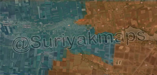
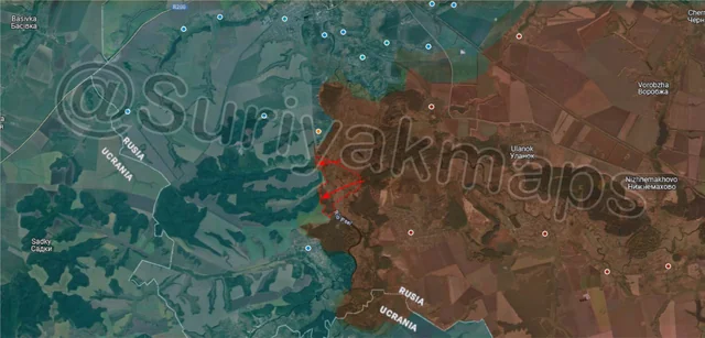
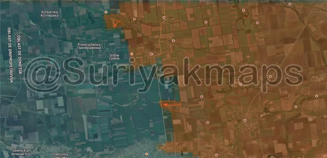
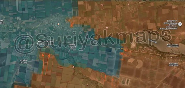
After the break our first update is on the Oskil River front, in the central area. Several days before, Russia had entered the eastern side of Novoiehorivka (only about 12 houses), taking over the eastern half. Today (1068), the few Russian troops who entered Novoiehorivka captured the western half, which was quite simple due to how small the settlement is and how few troops are in the area.

I’ll mention that the village west of here, Tverdokhlibove (blue dot), was also claimed by some Russian sources to have been captured, but others disputed this. Even more confusing, depending on the map used Novoiehorivka and Tverdokhlibove are called different names, and other maps even state that they are just the 1 settlement. This makes it quite difficult to determine exactly what is going on here as different sources are referring to different names when talking about this area.
Russian Forces Advance: 0.51 km²

Advance = 0.51km2

West of Kurakhove, following on from their deep breach along the trench network north of Andriivka the previous day, Russia has slightly expanded their spearhead here, capturing more defences to the north of the settlement. Clashes are ongoing on the north and east side of Andriivka, as Russia tries to breach even further into the town.
Russian Forces Advance: 1.70 km²

Advance = 1.70km2

In Chasiv Yar, Russia continued their attacks on the bunker and trench networks in the southern forest area, finally clearing Ukraine out and capturing them. With this, Ukraine has lost their second best defensive position in Chasiv Yar, and are in the process of losing their best (the central apartments + industrial area). As I’ve mentioned before, the western and southern side of Chasiv Yar is made up of small residential buildings, and is downhill of the central area, meaning if Ukraine is pushed back there they will not hold on for long.

On a side note, I’d love to see what the bunker complex in the forest looks like, even just the ruins, as its one of the more interesting mysteries from the war. The bunker dates back to the Soviet Union, and was reportedly expanded during the Ukrainian civil war, with all sorts of wild claims made about it (such as the “NATO Generals” one). Its also one of the incredibly few front line locations that has been hit with multiple Iskanders, which are typically reserved for high value targets in the rear.
Russian Forces Advance: 0.83 km²

Advance = 0.83km2

In Toretsk, over the past week Russia has cleared the forest area and abandoned warehouses on the northwestern side of the town. This does provide Russia a direct route to the far northern side of Shcherbynivka, which if captured would cut Ukraine off, however they are unlikely to head that way right now as it is quite exposed and would be difficult to maintain any foothold. Russia is most likely going to continue moving south to clear the remaining forest area, before reinforcing their units who are currently fighting in the middle of Shcherbynivka.
Russian Forces Advance: 7.70 km²

Top Advance = 2.34km2, Middle Advance = 3.08km2, Bottom Advance = 2.28km2

Moving to the northwest side of the Kurakhove front, starting with the upper advance, Russian troops captured the remaining section of Novoandriivka, confirming full control of the village. Ukraine’s surviving garrison have pulled back to Sribne, where there are reports that Russia is already attacking to try gain a foothold (no confirmation yet).

To the southeast, Russia made 2 advances west of Slovyanka and Petropavlivka respectively, capturing a decently sized area of fields as they push the frontline west. Most of these fields have no pre-built defences, so Ukraine is either not defending them on the ground, or has a few infantry scattered around in makeshift dugouts.
Russian Forces Advance: 2.92 km²

Advance = 2.92km2

On the Kursk front, Russia captured more of the forest area northeast of Guevo, as they expand their bridgehead on the west side of the Psel River. Whilst Russia would love to send their infantry deep into those forests to the west, Ukrainian positions in Guevo and the remaining half of Kurilovka (orange dot) make it too risky to try push much farther from their existing lines. Some small clashes are occurring around Guevo, however Russia has yet to make an attempt on the village itself.

As an aside, I'd like to mention we're seeing more and more Russian drone strikes on Ukrainian vehicles (logistics and others) in the border area over in Sumy. Russia has reportedly ramped up their attacks to exert further pressure on Ukraine's Kursk grouping, now that they are close enough to fly fibre-optic drones over the border (video 1, video 2, video 3). Whilst these aren't happening in great enough numbers to cripple Ukraine's Kursk force just yet, they are hampering their efforts and increasing the cost of holding onto the remaining area.
Russian Forces Advance: 1.56 km²

Advance = 1.56km2

On the north side of the Kupyansk front, Russia advanced through the north side of Dvorichna, fully capturing the town after 2 months of fighting. With this, Russia now has a good bridgehead on the west side of the Oskil River, and can begin pushing out deeper into Kharkiv Oblast, exploiting the weaker Ukrainian lines (discussed here). They’ll need to establish some pontoons and increase the buffer around the town before they can truly push much further out however.

As a bit of a refresher, Russia crossed the Oskil River at the end of November 2024 with a few small groups of infantry, and gradually continued to expand their control as Ukraine was unable to stamp them out due to lacking troops in this area. Russia did not use any vehicles in the capture of the town (no pontoons yet), had minimal artillery and MLRS support, and was able to take it with only a few infantry operating in small groups as Ukraine just had so few defenders they could not man most of the buildings. Ukraine also couldn’t reinforce the area as most of its units are stuck around Kupyansk unable to move as opening any gap in their defence of the pocket could lead to its collapse.

Ukraine was also reported to have pulled its surviving garrison out of Zapadne (bottom left), as Russia began attacking it a few days ago. Russia will likely take control of it within the next day or so once they have checked and cleared the village.
Russian Forces Advance: 0.96 km²

Advance = 0.96km2

Following on from picture 3, this time to the south of Chasiv Yar, a few Russian assault groups managed to push deep into Ukrainian lines through the forest, recapturing the small mine (lost on Day 998, mid-November), as well taking up positions on the southern side of the small lake. This puts Russian assault groups right next to the southernmost suburb of Chasiv Yar, with their goal likely to be capturing part of it whilst the main Ukrainian force here is preoccupied with defending the centre of the town. We’ll have to wait and see if these assault groups can maintain this precarious spearhead.

Russian Forces Advance: 1.08 km²

Advance = 1.08km2

On the far northwestern side of the Ocheretyne front, Russia made another small advance near Baranivka, capturing another field, some treelines and a trench network. As I mentioned last week, Russia is heading towards Vodayne Druhe, with the goal of seizing it and the surrounding Ukrainian trench networks so Russia can push over the Myrnohrad-Kostyantynivka highway.

On a related note, Ukraine blew up the interchange bridge of this highway about 3km west of this advance, to stop Russia being able to use the bridge to push further north.
Russian Forces Advance: 2.12 km²

Top Advance = 0.53km2, Bottom Advance = 1.59km2

Following on from picture 5, to the north, Russia advanced to the south of Nadiivka, capturing another section of the tree plantation. Fighting continues in Nadiivka itself.

To the south, Russia continued making advances in the fields and treeines west of Slovyanka, capturing several more and occupying part of the road to Andriivka. This road hasn’t been used by Ukraine in a long time, so this advance won’t have any effect on the battle for Andriivka itself. Russia will continue advancing west over the road as they clear these open fields and push for the border between Dnipro and Donetsk Oblasts.
Russian Forces Advance: 6.85 km²

Top Middle Advance = 0.43km2, Top Right Advance = 1.32km2, Lower Middle Advance = 1.86km2, Bottom Left Advance = 3.24km2

Context
Following on from picture 7, Russian forces expanded their control of the area around Dvorichna following the capture of the town. On the north side, they captured a bit of the forest and the farm warehouses next to the town, as well as clearing some of the forest area alongside the Oskil River (abandoned by Ukraine a while ago). The latter advance increases the surface area where Russia can set up pontoon bridges (if they haven’t already).

To the southwest, Russia cleared more of the fields and started moving into the forest area along the southwest road. A lot of Russia’s focus will be on clearing out these forests around Dvorichna so that it can be properly secured and the buffer for counterattacks increased.

West of this, Russia captured Zapadne after a few days of fighting, and has also taken control over some of the fields and the small forest area south of the settlement. This is the second settlement captured by Russian on this bridgehead, and opens the way for further advances west and south.
Russian Forces Advance: 2.28 km²

Top Advance = 0.59km2, Middle Advance = 1.47km2, Bottom Advance = 0.22km2

On the Pokrovsk front, to the north, Russia advanced slightly further up the railway east of Kotlyne, as the clear the fields and treelines in that area. This doesn’t look to be the beginning of an attempt to reach Pokrovsk (yet), but rather securing the flanks.

To the south, Russia made a small advance through the fields south of Novovasylivka, capturing several of them as well as a couple of treelines.

Even further south, following on from picture 5, the Russian troops that captured Novoandriivka have moved on west, capturing the long treeline on the west side of the settlement. We also now have confirmation that Russia is indeed beginning to assault Sribne, although no information from the initial clashes has been released yet.
Russian Forces Advance: 9.09 km²

Upper Left Advance = 0.22km2, Upper Right Advance = 1.21km2, Middle Left Advance = 4.10km2, Upper Middle Right Advance = 1.06km2, Lower Middle Right Advance = 0.05km2, Bottom Right Advance = 2.45km2

Following on from picture 2, in Andriivka, Russian troops made another small advance, entering the eastern side of the town from the north, and taking up positions in the first few houses. It looks like Russia is trying to squeeze Ukraine out from the eastern side of Andriivka by threatening to cut them off from the north, and if successful, it should make it easier for Russia to reinforce their assault groups as the eastern road leading to Shevchenko will be opened up.

To the southeast, in Dachne, Russia’s assault on the town continued, with their assault groups taking over the remainder of the eastern side and a chunk of the centre of the settlement. From the reports, as usual Ukraine is struggling with lack of infantry, and their only method of stopping or slowing down the Russian assault is via drones, which can only do so much.

To the south, Russia continued to close the Kurakhove pocket, advancing further north of Yantarne and capturing several fields. With Ukraine preoccupied with Dachne, there is not much they can do to stop Russian progress on this side.

Moving west, a Russian mechanised group advanced towards Kostyantynopil, capturing multiple fields and treelines to the south of the settlement. For now, Russian forces haven’t actually entered Kostyantynopil, however they are getting uncomfortably close for Ukraine’s liking, especially given that the mouth of the Kurakhove pocket is now only 4.5km wide. If Russia does start assaulting Kostyantynopil, Ukraine will have to pull out of the entire pocket or risk being encircled.
Russian Forces Advance: 6.17 km²

Top Right Advance = 3.62km2, Lower Left Advance = 2.55km2

On the Velyka Novosilka front, in the town itself, Russian forces cleared the last of the fields next to the Mokri Yaly River, which had been abandoned by Ukraine once the town fell (just needed to be cleared of stragglers, if any). For now the Russian grouping on this front is still resting and reorganising, but will likely begin to move out again sometime in the next 2 weeks.

To the northwest, Russia captured another field on the southwestern side of the Kurakhove front at the same time as the advance mentioned in picture 13. This one is to the south of Rozlyv, however Russia hasn’t made a move on the village yet, preferring to expand their control of the surrounding area.