Back home
Post #183

RU POV: Russian and Ukrainian advances from Day 1163 to 1165 of the War - Suriyakmaps

May 1, 2025 — May 3, 2025 War Day 1163–1165

Pictures 1 to 6 are from Day 1163 (Thursday 01 May), pictures 7 to 10 are from Day 1164 (Friday 02 May April), and pictures 11 to 16 are from Day 1165 (Saturday 03 May).

------------------------------------------------------------------------------------------------------

A reminder that these maps are confirming updates from previous days (i.e. typically 12 to 48 hours delayed from each day).

Ukrainian Advance
1.92 km²
Overall (set): 1.92 km²
Russian Advance
48.80 km²
Net Change
-46.88 km²

Situation Snapshots

Imagery, commentary, and territorial changes from the period.

17 entries
Russian Forces Advance: 5.29 km²

Advance = 5.29km2

We’re beginning this update in Sumy, just south of the Ukraine-Russia border. Over the past 2 days Russian infantry have expanded their control of Bilovody, seizing most of the village. The remaining area is under immense pressure as Russia seeks to capture yet another settlement in Sumy Oblast to expand their border control. The loss of Bilovody would make Ukrainian positions in neighbouring Vodolahy (next settlement west) untenable, as Russian troops can establish fire control over the only supply route and attack the village from 3 different sides.
Context

No Advance

Moving over to the Oskil River front, over the past week Russian forces have once again tried to move into Torske from the north. Whilst Ukrainian troops did drive them out in a counterattack earlier, they too were unable to hold the positions in the ruins of the town and so were forced to pull back across the Zherebets River. For now Russia hasn’t been confirmed to have secured a foothold, so the area has moved into the greyzone, but they are certainly working on it.
Russian Forces Advance: 0.42 km²

Advance = 0.42km2

North of Chasiv Yar, Russian troops made a minor advance in the forest area west of Hryhorivka. As mentioned last post, fighting in this area is pretty light and advances are mostly opportunistic or positional.
Russian Forces Advance: 11.00 km²

Top Right Advance = 8.56km2, Middle Advance = 1.93km2, Middle Right Advance = 0.36km2, Far Right Advance = 0.15km2

Onto the most notable event this week, on what is now becoming the Kostyantynivka front. Before Russian forces had even cleared the last couple of houses in Tarasivka, they were already beginning to work on hitting Ukrainian equipment and troops around Oleksandropil and in Novoolenivka. Russian troops look to have spotted some sort or weakness or opening in this particular area of the front and with the Ukrainian unit in this area (109th TDF), as they suddenly launched a motorcycle attack from Tarasivka and quickly broke through into Novoolenivka, taking up positions in the village. The Ukrainian garrison were seemingly caught completely off-guard, and quickly retreated further north in the settlement, where clashes are ongoing. This is part of what people mean when they say Ukraine is "entirely reliant on drones". If they don't spot the Russians or don't intercept these assault groups, Ukraine just does not have the manpower to properly protect their positions and fortifications, so they can very quickly end up being outflanked or overrun. For now Russia is trying to expand its control and capture all of Novoolenivka, which will have serious consequences for this entire front (see comment below).

There were also some minor Russian advances north of Zelene Pole and east of Berezivka, with several more treelines and small defensive positions captured.

To the west, a Russian assault group managed to capture the collapsed highway interchange and adjacent trench network, putting Russian on the outskirts of Malynivka. The fighting for this area is being conducted separately to the ones mentioned above, with Russia’s focus here being to flank Myrnohrad and Pokrovsk from the east.
Russian Forces Advance: 4.21 km²

Top Right Advance = 0.46km2, Middle Left Advance = 3.75km2

Heading to the Pokrovsk front, starting on the east side, the Russians were able to captured the remainder of the fields and treelines west of Lysivka, leaving Ukraine with only a minute foothold on the south side of the Solonyi River. Fighting continues over Lysivka itself.

Heading west, a Russian DRG managed to sneak into the southern suburb of Pokrovsk, causing alarm amongst Ukrainian sources. Whilst it is still far too early say the battle for Pokrovsk proper has begun, as I doubt this Russian group stayed there for long, it does highlight that Russia is indeed still quite close to the city and the siege could begin at any time.

Southwest, Russian assault groups managed to clear the remaining treelines south of Uspenivka, as well as establish a foothold in Novooleksandrivka. As previously mentioned, the capture of this village would finally put an end to the back and forth fighting for Uspenivka and could open the way for Russian forces to reach Dnipro Oblast (8km west of Novooleksandrivka).
Russian Forces Advance: 0.80 km²

Advance = 0.80km2

On the West side of the Kurakhove front, followed several more days of heavy bombardment (video 1, video 2), the first Russian assault group has entered Bahatyr, taking up positions in the southeastern houses. This battle will likely be a long one as the town is well fortified and there is a decently sized Ukrainian garrison here, hence why Russia has been heavily shelling and bombing it for almost a month now.
Russian Forces Advance: 1.13 km²

Advance = 1.13km2

On the Siversk front, the Russian campaign to clear out the numerous defensive positions in the hills continues. Russian troops made a few more advances here over the last week, but as usual progress is slow as there are many drones and numerous positions to clear one by one.
Russian Forces Advance: 1.10 km²

Top Right Advance = 0.94km2, Upper Middle Advance = 0.16km2

On the Toretsk front, starting with the northeast, Russian troops continued to push up the Balmutka River west of the canal, clearing out part of the treelines and defensive positions on their way towards Dyliivka.

Southwest, the Russian group that reached the small reservoir north of Krymske was able to expand its control, clearing out more of the forest area. Once this forest area has been cleared Russia should be able to cut off the last supply route for the few Ukrainian groups still entrenched in northern Toretsk.

A bit further west in the Novodzerzhinskaya mine, Russian forces have managed to drive Ukraine from the complex, however have been unable to properly secure all the buildings at this point. They are currently working on it, but due to how exposed the mine is and the density of drones moving out of cover is obviously quite dangerous. The capture of the mine would allow Russia to put further pressure on the area north of Toretsk, as well as begin to try cut Shcherybnivka and Novospaske off from the north.
Russian Forces Advance: 11.07 km²

Left Advance = 0.30km2, Upper Right Advance = 5.52km2, Lower Right Advance = 0.13km2, Far Bottom Left Advance = 1.35km2, Bottom Left Advance = 1.77km2, Bottom Middle Advance = 2.00km2

Following on from picture 4, beginning with the west side, Russian troops have entered Malynivka, taking up positions in the warehouses on the far eastern side of the town.

Slightly south, Russian troops have entered Yelyzavetivka once again, looking to secure it properly this time as they now control a larger portion of the surrounding fields and trench networks (including a few more captured to the west). If Russia can secure the village, they will be able to reinforce their groups trying to assault Myrolyubivka, as well as attack Malynivka from the southwest side.

Over to the east, Russian forces continue to clear the fields and treelines between Zelene Pole and Kalynove, capturing several more. They are still eyeing up Stara Mykolaivka, but are prioritising straightening the frontline somewhat before they commit more forces to assault the village.

Even further east, following their capture of Sukha Balka last week Russian assault groups have moved north, taking over an area of fields and some trench networks east of the highway. Interestingly they look to be avoiding crossing the highway itself to help out in attacking Stara Mykolaivka and are instead aiming at attacking Romanivka. Already there are videos showing Ukrainian troops around Romanivka being hit by mortars and drones, so it looks like the battle for the village is fast approaching.
Russian Forces Advance: 2.51 km²

Middle Left Advance = 1.00km2. Lower Left Advance = 1.32km2, Bottom Left Advance = 0.19km2

Following on from picture 5, whilst clashes continued in Novooleksandrivka, another assault group moved into the next treeline west south of the settlement capturing it.

Further southwest, Russian forces have begun down the stream west of Nadiivka. Its unclear whether this group will head north towards Novomykolaivka, or join in on the attacks west to Kotlyarivka.

There was also a very minor advance up a treeline east of Troitske, as Russia tries to position itself for their second assault attempt.
Russian Forces Advance: 1.06 km²

Advance = 1.06km2

Following on from picture 2, Russian troops were confirmed to have captured the fish farm on the north side of Torske. They are still probing and scouting in the northern houses of the town, but haven’t been able to secure positions there yet.
Russian Forces Advance: 1.82 km²

Left Advance = 1.31km2, Right Advance = 0.51km2

Following on from picture 9, Russian assault groups captured the treelines around Berezivka, establishing a buffer around the village, as well as entering the southern outskirts of Nova Poltavka. Assaults of the latter have not begun quite yet, but should kick off within days once Russian command believes they have softened up the garrison and defensive positions enough.

Further east, a small Russian group moved up the treeline west of Oleksandropil. This is another settlement Russia is considering assaulting, however will likely try capture more of the surrounding area first whilst their drone teams work on the garrison.
Russian Forces Advance: 2.53 km²

Middle Left Advance = 1.11km2, Lower Left Advance = 0.11km2, Bottom Left Advance = 0.37km2, Far Bottom Left Advance = 0.94km2

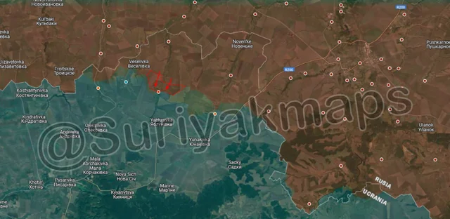
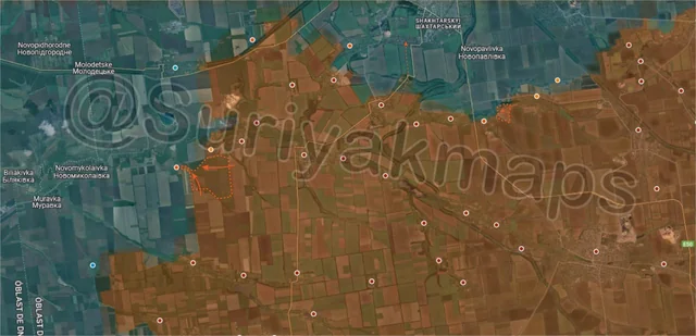
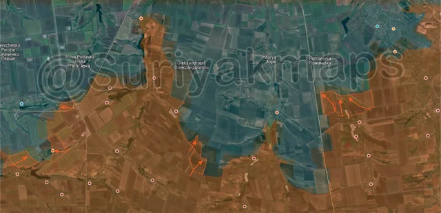
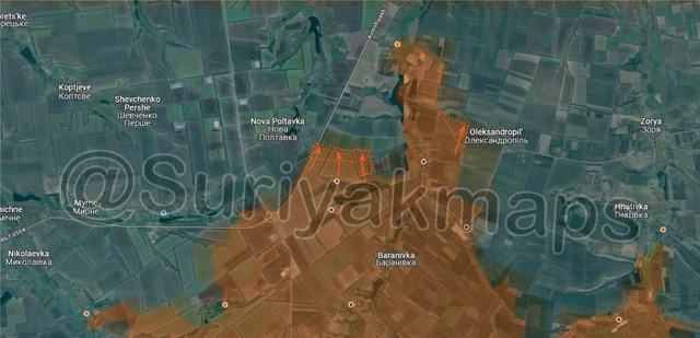
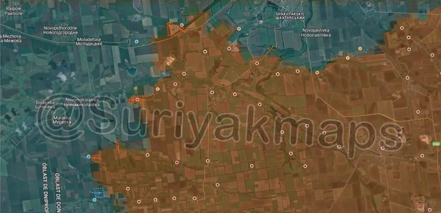
Following on from picture 10, starting with the northwest side, after over a month of positional fighting and clashes, Russian groups were able to re-enter northern Kotlyne as well as capture a farm to the west of the village. For a quick recap, Ukraine counterattacked in Kotlyne in late March (Day 1128) and was able to capture the northern side of the village. Despite a number of attempts they were unable to retake the industrial facility east of Kotlyne nor take the street on the south side of the railway, so the front has settled into a sort of stalemate. With Russia now back in northern Kotlyne, they may be able to retake the village and shift their focus to either capturing Udachne or the coal mine (both west of Kotlyne).

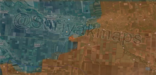
Southwest, after 2 days of fighting Russian assault groups captured Novooleksandrivka, securing the village. This opens the way for a push to Dnipro Oblast and also ends the months of clashes over Uspenivka. Novoserhiivka is the nearest settlement, however it sits on the opposite side of the Solona River with the nearest bridge being on the far western side, so Russia will likely avoid trying to attack it unless they intend to cross the river on foot.

Continuing on southwest, a small Russian infantry group was able to enter Kotlyarivka after crossing an anti-tank ditch. This is the second assault attempt on the village so we will have to wait and see if it is more successful. The capture of Kotlyarivka would also open the way for Russia to reach Dnipro Oblast, as it sits just 3.65km from the border (only treelines and fields).

Slightly south, a small Ukrainian group counterattacked north of Troitske and recaptured the trench in one of the treelines. Video footage has already emerged of Russia hitting said trench with artillery and drones, so I would question how long this Ukrainian group will last before killed or forced to retreat back into Troitske.
Russian Forces Advance: 1.80 km²

Top Advance = 0.82km2, Bottom Advance = 0.98km2

Heading up to the Oskil River front, after well over a month of silence we finally have an update on Stepy and Kopanky after Ukraine launched some larger counterattacks in April. Russia was confirmed to have recaptured all of the former, whilst Ukraine expanded its control of the latter (now over half the village). Clashes continue in this area and the tide could shift in either side’s favour.
Russian Forces Advance: 1.10 km²

Advance = 1.10km2

Following on from picture 7, Russian assault groups have cleared the dugouts and trenches in the hills up to the eastern outskirts of Hryhorivka. The village itself essentially does not exist, with there barely being any rubble to hide in for either side (hence it sitting in greyzone). If Russia wishes to capture this area they will need to seize the Ukrainian trenches south of Hryhorivka, although reaching them from the east side will be challenging.
Russian Forces Advance: 2.96 km²

Advance = 2.96km2

On the Velyka Novosilka front, over the past couple of days Russian troops have captured some of the fields and treelines between Novosilka and Vilne Pole, likely part of an attempt to flank the village from the south. I do disagree with Suriyak’s mapping here showing Novosilka as split between both sides, as there has been no evidence of Ukrainian troops in Novosilka in well over a months.

Vilne Pole continues to be the site of some intense bombardment, with a notably high usage of Krasnopol rounds used to pick off individual Ukrainian positions.
Ukrainian Forces Advance: 1.92 km²

Top Left Advance = 1.92km2,