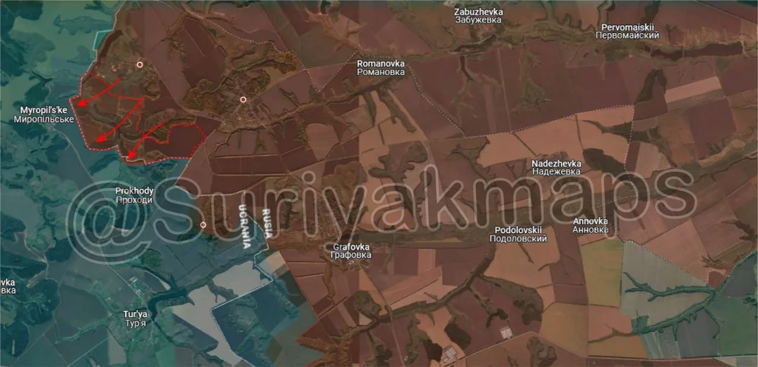
Back home
Post #187

RU POV: Russian and Ukrainian advances from Day 1176 to 1180 of the War - Suriyakmaps

May 14, 2025 — May 18, 2025 War Day 1176–1180

Pictures 1 to 6 are from Day 1176 (Wednesday 14 May), pictures 7 to 11 are from Day 1177 (Thursday 15 May), pictures 12 to 14 are from Day 1178 (Friday 16 May), pictures 15 and 16 are from Day 1179 (Saturday 17 May), and pictures 17 to 20 are from Day 1180 (Sunday 18 May).

------------------------------------------------------------------------------------------------------

A reminder that these maps are confirming updates from previous days (i.e. typically 12 to 72 hours delayed from each day).

Ukrainian Advance
1.64 km²
Overall (set): 1.14 km²
Russian Advance
91.74 km²
Net Change
-90.10 km²

Situation Snapshots

Imagery, commentary, and territorial changes from the period.

20 entries
Russian Forces Advance: 3.89 km²

Advance = 3.89km2

We’re starting off in Belgorod today, where Russian infantry have gradually cleared the last of the forest areas on their side of the border over the past week. This only leaves a few small forest areas southeast of here near Prilese under Ukrainian control, although other mappers (both Russian and Ukrainian) say that those are either greyzone or Russian controlled. Either way its safe to say this particular Belgorod incursion is over, with only some minor cleanup left.
Russian Forces Advance: 4.36 km²

Advance = 4.36km2

On the Oskil River front, Russian troops were able to recapture some of the fields and treelines west of Vyshneve. The frontline is still static in Kopanky (Above the a) with neither side trying to move out of their positions at the moment.
Russian Forces Advance: 5.30 km²

Top Advance = 2.44km2, Upper Middle Advance = 0.13km2, Middle Left Advance = 0.35km2, Lower Left Advance = 2.29km2, Bottom Advance = 0.09km2

Further south on the same front, Russia continues to make advances west of the Zherebets River. Going counterclockwise, Russian infantry groups have cleared out more forest areas and fields around Hrekivka, closing in on the settlement. They aren’t meeting much resistance (only drones) as Ukraine’s forces have had to retreat back to the village due to lack of troops.

Southwest, Russia made a small advance northwest of Nove. The focus on the forces in this area are on Ridkodub (north of this advance), however we have not had any updates on the progress of the battle since Russia first entered the village.

To the south, another group of Russian infantry cleared out some of the treelines southeast of Zelena Dolyna, as they gradually move in on the village.

Southeast, clashes continue in Kolodyazi, with Russian assault groups taking over some of the industrial buildings on the north side of the village.

Russian Forces Advance: 2.94 km²

Top Right Advance = 0.16km2, Upper Right Advance = 0.32km2, Middle Left Advance = 0.27km2, Middle Right Advance = 2.19km2

Heading over to Toretsk, the front remains as messy and fluid as ever. Going northeast to southwest, a small Russian group crossed the canal from Ozarianivka and occupied the fortifications in the forest area.

To the southwest, Russian troops have remained active near the Balmutka River, taking over a bit more of 2 treelines.

Between Krymske and Dachne, Russian assault groups have squeezed the last remnants of Ukrainian troops out and captured the field and part of the railway, establishing another link to Dachne (will assist with attacking Dyliivka).

To the west, Russian DRGs operating around the small reservoirs have moved west into some of the fortifications north of Toretsk. They are looking for openings or weaknesses in Ukrainian lines so they can push out of Toretsk and finally end the battle for the town.
Russian Forces Advance: 10.65 km²

Top Left Advance = 1.11km2, Far Left Advance = 2.33km2, Left Advance = 0.72km2, Middle Advance = 2.14km2, Left Bottom Left Advance = 0.63km2, Right Bottom Left Advance = 0.30km2, Lower Middle Advance = 0.25km2, Bottom Advance = 3.17km2

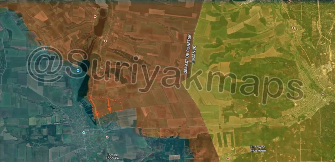
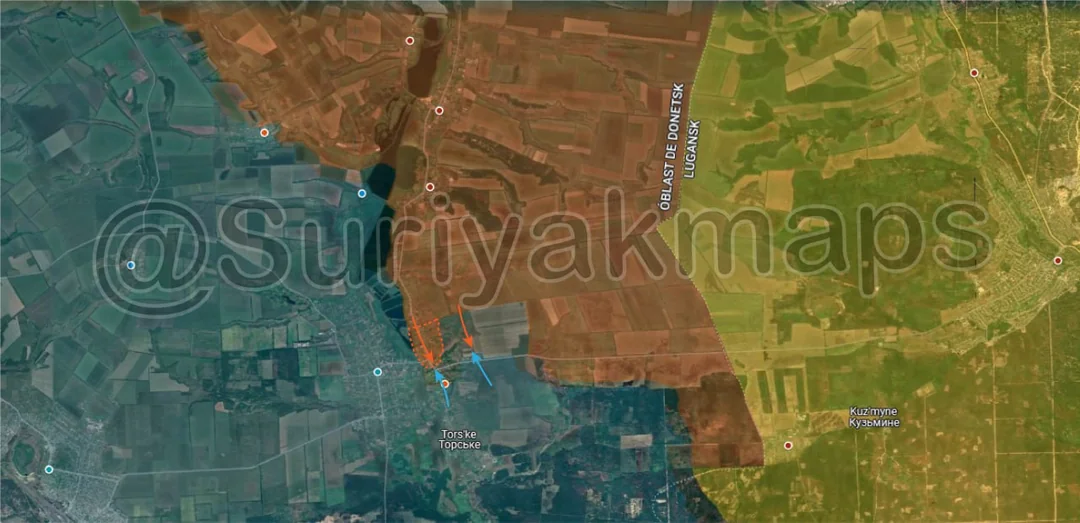
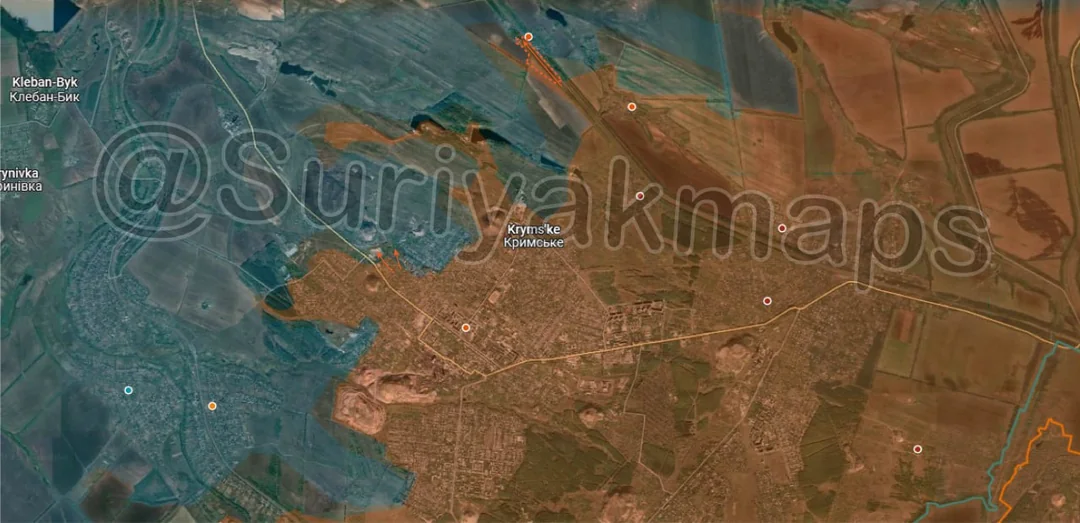
Over on the Kostyantynivka front, Russian assault groups across the entire front have continued to make gains in all attacks. Going counterclockwise again but this time starting from the southeast, Russian assault groups have begin to clear out the small pocket southeast of Stara Mykolaivka. This area has been abandoned for Ukraine for a little while now, however they still need to check each treeline/fortification for stragglers who did not make it out. There is no movement in Stara Mykolaivka itself.

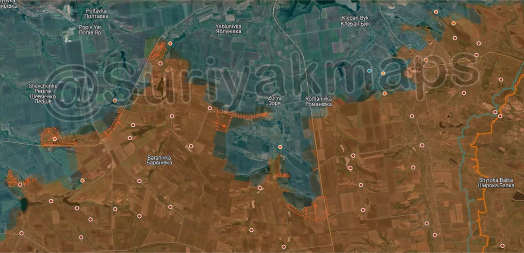
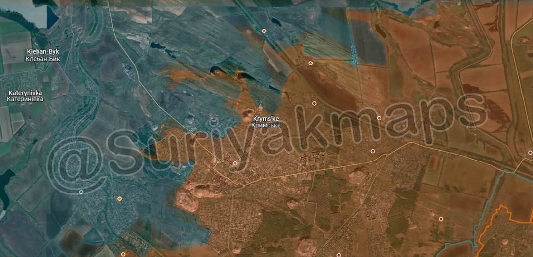
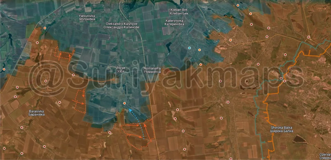
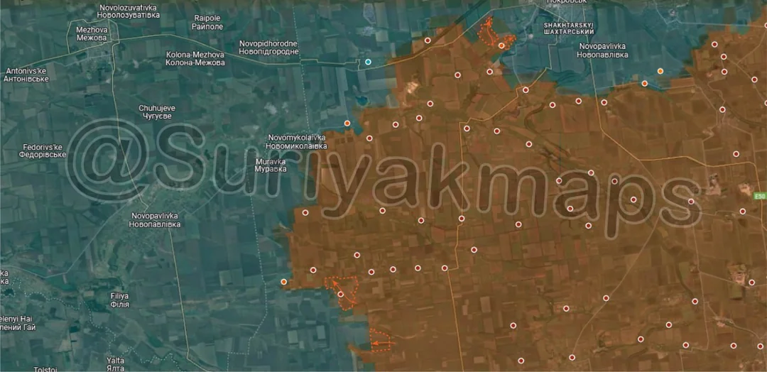
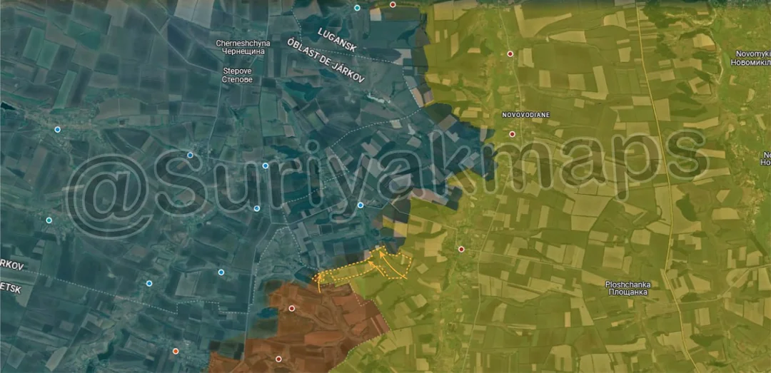
West of Zorya, Russian motorcycle groups have made an aggressive advance from Oleksandropil towards Zorya, with a number of infantry reaching and taking up positions along the treeline just southwest of the small town. They have not actually entered Zorya at this stage, however the pressure is ramping up and Ukrainian positions are becoming increasingly untenable as Russia outflanks or bypasses defences.

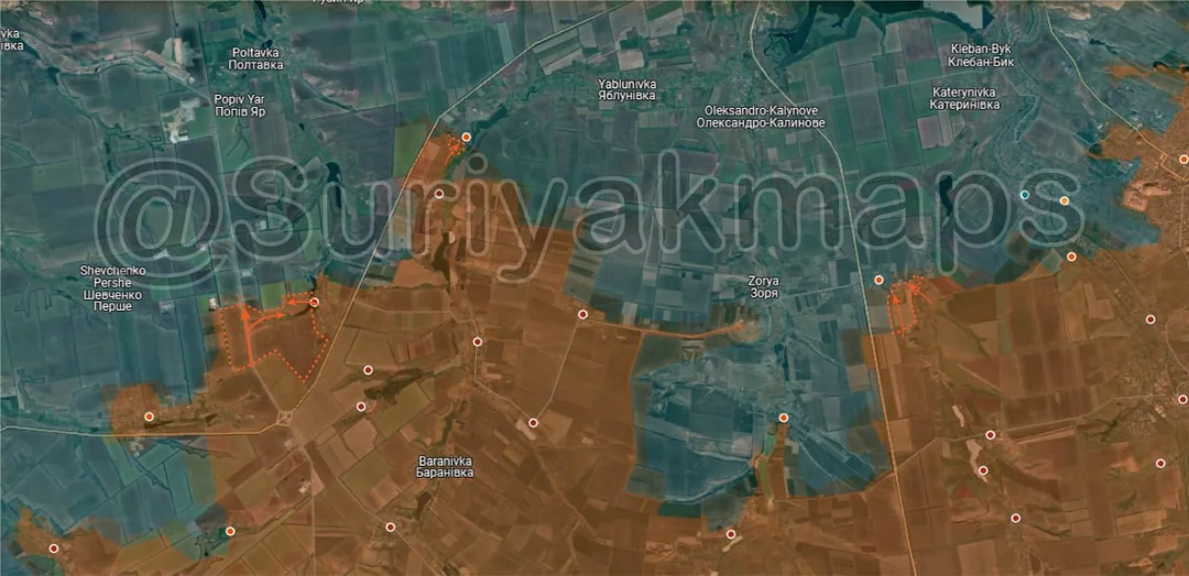
North of Novoolenivka, Russian assault groups have begun moving up the fortification line and clearing out the various trenches and bunkers. As discussed in previous posts, they are using this Ukrainian defence line as continuous cover to try reach Yablunivka.

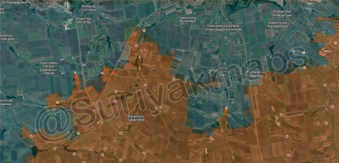
Southwest, Russian forces near the highway interchange have cleared some of the empty treelines south of Nova Poltavka, in preparation for further attacks north (possibly to the west side of Nova Poltavka).

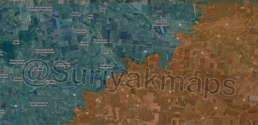
West of this, Russian assault groups in Malynivka have continued to clear the small town, capturing the remainder of the centre of the settlement as well as the 2 fortification networks on the north side. There are only a couple of houses on the western edge left to clear before Russia controls the settlement, but those haven’t been confirmed yet.

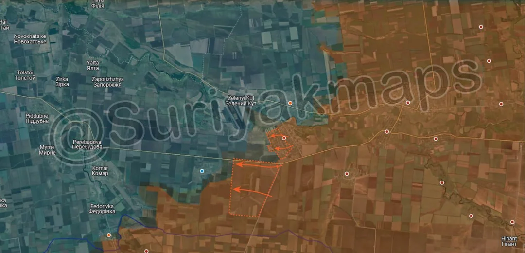
Southwest, Russian assault groups that took over most of Myrolyubivka (see last post) have been confirmed to have cleared the last houses on the north side, confirming full control of the settlement. Russian troops also captured the small village of Mykhailivka on the opposite side of the Kazenyi Torets River at the same time, as it is barely 200m away from Myrolyubivka and there was no chance for Ukraine to hold it when Russia was in control of this area. This puts Russia into a position to assault Mykolaivka (small village north, east side of river), however they will likely tree clear the fields, treelines and many fortifications between Myrolyubivka and Malynivka first.
Russian Forces Advance: 3.54 km²

Advance = 3.54km2

Back to the Oskil River front, this time on the south side where Russia has continued their push into Torske. They have managed to take more of the northern street and are clashing with Ukrainian troops in the central area (as of this day).
Ukrainian Forces Advance: 1.06 km²

Advance = 1.06km2

Following on from the previous picture, Russian assault groups were confirmed to have made more progress in central Torske, taking over a portion of the central area of the settlement. Despite the claims of the Russian MOD, Russia does not yet control Torske and still needs to clear and capture the south side of the town.
Russian Forces Advance: 0.17 km²

Advance = 0.17km2

In Chasiv Yar, after weeks of slow clashes and positional battles Russian forces were confirmed to have cleared and captured several buildings in the centre of the town. A number of Russian sources claim they have completely captured all of central Chasiv Yar, however this has not been confirmed. If Russia were to take the central apartment buildings, the battle would speed up towards it conclusion as Ukraine would lose its strongest position in the town and Russia could begin focusing their attention downhill.
Russian Forces Advance: 0.09 km²

Advance = 0.09km2

Following on from picture 4, Ukrainian troops made a small counterattack east of Dachne, retaking a couple of defensive positions in the treeline. Due to the Russian advance seen in picture 4, Russian forces in Dachne are no longer dependent on these treelines for supplies, so this counterattack has limited impact on the fighting in this area.

Russian Forces Advance: 12.79 km²

Top Left Advance = 1.47km2, Middle Left Advance = 2.49km2, Bottom Advance = 8.83km2

Following on from picture 5, starting on the southeast side, Russian forces were confirmed to have cleared another chunk of the pocket southeast of Stara Mykolaivka. They have also cleared more of the treelines west of the settlements and are continuing to close in on the village from multiple sides.

To the northwest, a separate group also pushed north of Oleksandropil and has been clearing treelines and fields on the way towards Yablunivka.
Russian Forces Advance: 6.95 km²

Middle Advance = 2.42km2, Middle Right Advance = 3.41km2, Bottom Left Advance = 1.12km2

On the Velyka Novosilka front, starting with the northeast side, Russian infantry groups have continued exerting pressure on Odradne and Bahatyr, seizing several more fields and treelines around those settlements. This does put Russian troops within 100m of Odradne, although assaults have not yet started (just lots of bombardment).

To the southwest, after a week of fighting Russian assault groups captured the remainder of Vilne Pole, establishing full control over the settlement (video 1, video 2). This opens up a decent amount of space for Russia to push west towards the Donetsk-Dnipro border, as well as possibly flank Shevchenko from the south side.
Ukrainian Forces Advance: 0.58 km²

Advance = 0.58km2

Following on from picture 7, Ukrainian forces counterattacked over the Zherebets River, retaking the fish farm and capturing a few POWS. This does not completely cut off the Russian assault groups within Torske as they control the fortifications on the hill northeast of the settlement, but it does put them in an awkward position. It will be difficult for Ukraine to push much further as their supplies and reinforcements are limited to the 3 paths over the Zherebets River, all in close proximity to each other (easy to intercept).
Russian Forces Advance: 0.13 km²

Advance = 0.13km2

Following on from picture 9, Russian troops pushed up the railway into Dyliivka, where clashes are occurring.
Context Advance: 6.81 km²

Left Top Right Advance = 1.40km2, Right Top Right Advance = 0.46km2 Lower Middle Advance = 3.22km2, Bottom Advance = 1.73km2

Over to the Pokrovsk front, southwest of the city itself, Russian forces have increased their pressure and have continued to close in, capturing several fields, treelines and the slagheap west of Pokrovsk. They’ve also continued to clear Leontovychi and Zvirove, taking several more streets in those two villages. The latter advance is somewhat surprising, as Ukraine should have that area locked down due to its proximity to the numerous drone crews within Pokrovsk (very short flight time). Whilst this does put Russian forces about 1km from the first houses of Pokrovsk, I do not believe they will try assault the city yet as it is quite the awkward angle to send assault groups from (would funnel them into one path).

To the southwest, Russian assault groups moved from Zaporizhzhya and captured Bohdanivka, which became untenable for Ukraine when Russia captured Troitske (previous week). They’ll be looking to move west out of that village to assist with their push towards the Dnipro Border. There was also a small advance south of this, with Russia clearing out a field and treeline near some of the earlier advances.

Russian Forces Advance: 3.94 km²

Left Advance = 3.43km2, Middle Left Advance = 0.38km2, Lower Right Advance = 0.13km2

Following on from picture 10, starting on the east side, the first Russian assault group entered Stara Mykolaivka, taking up positions in the southern houses. Some clashes are occurring as they try expand control of this area, but Ukraine’s garrison and forces in this area are abandoning their positions as they try retreat back to Zorya (due to the potential of encirclement).

To the west, Russian assault groups have made more progress in Nova Poltavka after over a week of silence and captured the southern half of the village. They are currently attacking the remaining half, with Ukraine reportedly being driven back.

West of this, Russia launched a small mechanise attack from the south up past Malynivka, dropping off troops in one of the farms to the north. Russian command is increasingly adding new assault groups and different directions of attack before previous battles have ended, trying to overwhelm Ukrainian forces.
Russian Forces Advance: 13.36 km²

Middle Advance = 2.34km2, Lower Left Advance = 11.02km2

Following on from picture 11, Russian assault groups have captured the remainder of Bahatyr after days of heavy clashes, confirming full control of the town (video 1, video 2). There was a lot of confusion over this as Ukrainian command tried to deny these events by dropping a Ukrainian flag from a drone on the southeast side of Bahatyr and sending in a recon group (2 men) to take down and stand on a Russian flag on the west side of Bahatyr. This was all futile however, with the former video making no sense as it was filmed days prior and showed no proof of Ukrainian ground presence in the area, and the latter resulted in the recon group being killed shortly after.

With Bahatyr under control, Russian troops were also able to start clearing the fields and treelines southwest of the town. Odradne is in an incredibly dire position, as even if the garrison somehow holds the settlement itself Russia can simply encircle it by bypassing the village from the north side of the road.
Russian Forces Advance: 2.80 km²

Advance = 2.80km2

Following on from picture 3, Russian troops made further advances around Hrekivka over the past 2 days, taking several fields and treelines.

Russian Forces Advance: 0.20 km²

Advance = 0.20km2

Following on from picture 4, within Toretsk Russian forces have cleared another street on the north side of the town, gradually shrinking Ukraine’s remaining foothold there. Progress is still incredibly slow however.
Russian Forces Advance: 8.09 km²

Upper Left Advance = 0.15km2, Left Advance = 6.87km2, Right Advance = 1.07km2

Following on from picture 15, starting on the east side, Russian assault groups have continued to put pressure on Romanivka, taking over some of the adjacent fortifications. They have also begun the first assault on the village, which we should receive information on within the next few days.

Northwest, Russia made a small advance along the previously mentioned fortification line.

Southwest of that, Russian assault groups in Nova Poltavka finished clearing out the last houses and warehouses in the village, confirming full control of the settlement (video 1, video 2). There was also a Russian group working in tandem with them who cleared out the fields and treelines along the road west of the village.
Russian Forces Advance: 12.54 km²

Upper Left Advance = 1.26km2, Lower Left Advance = 1.37km2, Left Bottom Left Advance = 0.47km2, Right Bottom Left Advance = 1.44km2

Following on from picture 14, Russian forces operating north of Kotlyarivka cleared out 2 fields and part of 2 treelines, as they position themselves for an attack on either Novomykolaivka or Muravka.

South of this, Ukraine launched a counterattack in Horikhove, retaking the central street. Russian infantry in the village held on the eastern street, with heavy clashes ongoing. Southeast of this another Russian group moved out of Bohdanivka to the west, capturing some fields and treelines, forming another mini-pocket in the area to the south (likely empty).