Back home
Post #201

RU POV: Russian and Ukrainian advances from Day 1229 to 1231 of the War - Suriyakmaps

Jul 6, 2025 — Jul 8, 2025 War Day 1229–1231

Pictures 1 to 6 are from Day 1229 (Sunday 06 July), pictures 7 to 13 are from Day 1230 (Monday 07 July), and pictures 14 to 20 are from Day 1231 (Tuesday 08 July).

------------------------------------------------------------------------------------------------------

A reminder that these maps are confirming updates from previous days (i.e. typically 12 to 72 hours delayed from each day).

Ukrainian Advance
17.18 km²
Overall (set): 16.68 km²
Russian Advance
53.51 km²
Net Change
-36.33 km²

Situation Snapshots

Imagery, commentary, and territorial changes from the period.

21 entries
Russian Forces Advance: 4.41 km²

Advance = 4.41km2

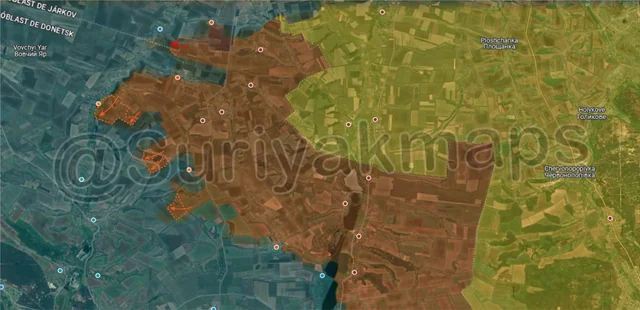
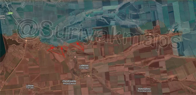
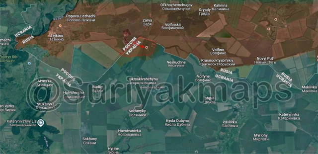
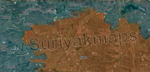
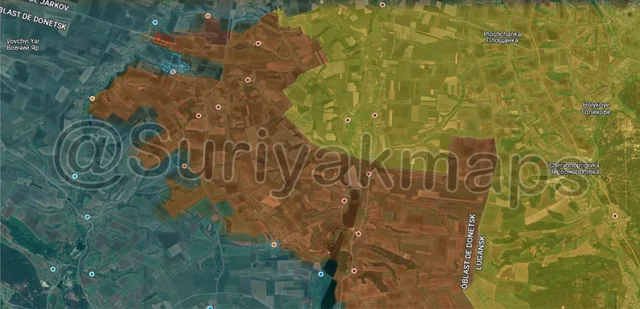
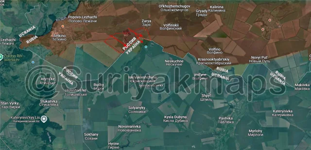
We begin this update off in the Kursk border area, where after securing the trench network east of Tetkino a few days prior, Russian troops continued to advance and have now cleared the remainder of the sewage treatment plant and several treelines. As mentioned before, Ukraine was forced to redeploy their units from this area despite finally making progress due to the Russian advance north of Sumy city. This has left Ukraine with insufficient forces to hold their foothold around Tetkino (aside from across the river), so Russia has been able to knock/wipe out the few Ukrainian groups left.

The Russian squad that cleared the treeline south of Zarya has also reportedly crossed into Sumy and is in the forest around Bezsalivka.
Russian Forces Advance: 5.66 km²

Top Left Advance = 0.20km2, Upper Left Advance = 3.09km2, Middle Left Advance = 1.40km2, Lower Left Advance = 0.97km2

Over to the Oskil River front, where Russia has made advances in several areas. Starting on the north side, the Russian infantry north of Ridkodub are continuing their attempts to reach Hlkushchenkove, having moved slightly further west along 2 treelines.

To the southwest, the Russian assault groups in Karpivka have made further progress, securing the eastern side of the small town and the adjacent treelines. Their issue is now getting across the Nitrius River, as whilst they were able to slip over it quickly while Ukraine were not prepared a few weeks back, it will be more difficult to do so now that Ukraine is dug in. Ideally they would cross further north of Karpivka then work their way down, but because of the Ukrainian assault groups pushing into Ridkodub they have been unable to, leaving the crossings within the town as the only options.

Moving southeast, Russians squads on either side of Zelena Dolyna have advanced, capturing a few treelines. I have seen some reports from both Russian and Ukrainian sources the Zelena Dolyna has been cleared by Russia, but no evidence has been posted yet.
Russian Forces Advance: 1.09 km²

Very Top Advance = 0.88km2, Top Advance = 0.12km2, Upper Middle Advance = 0.09km2

Down to the Siversk front, where over the past week Russia was able to secure its positions in the ruins of Serebryanka and take over the entire eastern side of the settlement. They are now pushing in the central area, but as with this advance any progress will be slow.

Russia has also reportedly been making some small attempts to seize the fortifications on the eastern side of Siverk, with no success so far.
Russian Forces Advance: 2.01 km²

Left Advance = 1.22km2, Bottom Left Advance = 0.79km2

Onto the east side of the Pokrovsk front, Russia has expanded their control of the fields along the Kazenyi Torets River, taking over some fields southeast of Razine and beginning to push north to Novotoretske.

To the south, Suriyak updated the map to show Russia back in control of southern Myrolyubivka, which I mentioned in my post last week that I believed was never under Ukrainian control. Nonetheless, its accurate now although reports suggest Ukraine’s hold on the remainder of Myrolyubivka is weak.
Ukrainian Forces Advance: 10.36 km²

Upper Right Advance = 5.27km2, Upper Middle Advance = 1.41km2, Lower Middle Advance = 1.82km2, Lower Advance = 0.71km2, Bottom Advance = 1.15km2

On the Novopavlivka front, over the past week Ukraine counterattacked and managed to re-enter the western side of Dachne. To be clear, they did not completely recapture Dachne, nor were they in control of it the whole time, as video footage has shown Russian forces in Dachne when they first took it and more recently. I question the value in such an attack by Ukraine, as like their push with a few troops back into Bahatyr a few months back, losing soldiers just to wave a flag in a settlement you don’t control and won’t be able to retake is simply a waste of resources (and life).

To the west, on the Velyka Novosilka front, Russian assault groups in Tolstoi have made more progress and are pushing towards the western side of the village.

Slightly south of that, the Russian troops in Piddubne have slightly expanded the buffer around the settlement and have taken the fields to the south of it. They are likely preparing to assault Myrne, although I do not believe there are many Ukrainian soldiers left there.

Moving south again, there were some minor Russian advances in the fields south of Myrne and southeast of Voskresenka, clearing some treelines.
Russian Forces Advance: 2.01 km²

Left Advance = 1.31km2, Right Advance = 0.70km2

Over to the Zaporizhia front, the Russian assault on Kamyanske continues, with one of their groups sent to the southeast side clearing out the remaining buildings and fields. These were abandoned after the initial Russian push a few days back, but its now confirmed that Ukraine has no presence on the south side of the town.

There was also a small advance by a different Russian group in the fields east of here, as the attention on Kamyanske has opened the way for some smaller opportunistic pushes.
Russian Forces Advance: 2.96 km²

Advance = 2.96km2

Following on from picture 1, Russian troops were confirmed to have crossed into Sumy and captured the village of Bezsalivka. Whilst the village was defended by Ukraine during their operation to take Tetkino (as it was the main route of getting soldiers into Kursk), once Ukraine moved its units away to defend the other part of Sumy it was abandoned, with their soldiers preferring to hold in Iskryskivshchyna.

I have to say this is a complete mess for Ukraine. Whilst not critical in the slightest, Bezsalivka being captured is a spit in the face of yet another failed Ukrainian operation to take Tetkino. In early May Ukraine moved multiple units (some from other fronts but mostly from the other part of Sumy) to launch an incursion to take Tetkino. After over a month of assaults and heavy losses they finally began to make progress and looked like they could cut off the town, but it had come at the cost of larger Russian gains north of Sumy city where they captured multiple villages and over 100km2 in the same time period. Eventually the danger of the Russian advance forced Ukraine to pull its units back to the other part of Sumy to defend and counterattack, leaving Russia to undo their progress and now push slightly into Sumy.

So at the end of the day, Ukraine lost a large amount of manpower, equipment, multiple villages and over 100km2 of territory in Sumy, only to not take Tetkino anyway and end up far worse off than if they had just used those units on defence.
Ukrainian Forces Advance: 1.26 km²

Advance = 1.26km2

On the other part of the Sumy frontline, over the first week of July Ukraine has continued its counterattacks, this time focusing the western Russian flank. Ukrainian infantry groups have been pushing up the treelines and have managed to reach the outskirts of Kindrativka, where they have launched an attack on the village. Russia is bombing them, but they will likely be able to make it into the settlement.
Russian Forces Advance: 0.15 km²

Advance = 0.15km2

Over in Toretsk, Russian was confirmed to have recaptured the last section of the southern suburbs of the town. This has been greyzone for a long time and personally I believe Suriyak is quite late with this and should have updated the map weeks ago (no Ukrainian seen here in a long time).
Russian Forces Advance: 12.97 km²

Top Middle Advance = 5.09km2, Top Right Advance = 1.52km2, Left Advance = 1.86km2, Bottom Left Advance = 4.50km2

Following on from picture 4, on the north side, after weeks of clashes Ukraine was able to drive Russia out of Poltavka and recapture most of Popiv Yar, pushing them back into the fields south of the villages. They are now trying to establish a defence line just outside these settlements for the inevitable next Russian assault.

To the southeast, Russian assault groups in Yablunivka renewed their attacks and managed to recapture their positions in the centre of the town. Another group north of the river was able to take over one of the trench networks next to the settlement, from which they can push east to try cut off the remaining Ukrainian positions. There is still a decent amount of back and forth here, so the battle is likely to continue for a little while longer.

Heading west, Russian troops cleared the treelines south of Novotoretske as they gradually approach the settlement from the south. There is a decent stretch of open ground between the village and this advance, so unless Russia uses a motorised or mechanised group to gain a foothold, their infantry will have to attack Novotoretske from the east side.

To the south of there, Russia launched a surprise mechanised assault on Novoekonomichne with a tank and two MT-LBs, which were able to reach the southern side of the town and drop off troops. If these troops can fan out and clear the southern streets, Russia will have a firm foothold from which to assault the town. This was quite unexpected as they do not have firm control of Myrolyubivka and had not entered neighbouring Mykolaivka, but they must have believed the Ukrainian garrison to be weak enough to try attack directly.

With the benefit of hindsight, my suggestion from the previous post that the capture of Razine could point to a desire to attack Novoekonomichne might actually be true. We will have to wait and see if Russian troops from Razine do in fact push down to attack northern Novoekonomichne.
Ukrainian Forces Advance: 0.25 km²

Advance = 0.25km2

On the opposite side of the Pokrovsk front, a small Ukrainian infantry groups has tried pushing back into Novoserhiivka, reaching and taking up positions in the western houses. They have almost immediately been hit by Russian artillery who spotted them and unless more assault groups are sent in it is unlikely they will have the forces to push and retake Novoserhiivka.
Russian Forces Advance: 3.17 km²

Advance = 3.17km2

Following on from picture 5, Russian troops in Piddubne have now expanded the buffer to the west of the settlement as well, clearing several fields and treelines. With rather weak Ukrainian lines here, they will likely be able to keep moving west with minimal resistance until they get closer to Oleksandrohrad.
Russian Forces Advance: 0.51 km²

Advance = 0.51km2

Following on from picture 6, Russian assault groups in Kamyanske have completed their capture of the western side of the town and entered the first houses of Plavni. Plavni is made up of many Dachas and houses, so there is a decent amount of cover for them to use if they continue to push north.
Ukrainian Forces Advance: 3.70 km²

Left Advance = 3.70km2

Following on from picture 8, Ukrainian assault groups crossed the road between the border and Khotin, entering and taking over part of Kindrativka. Russia is currently bombing them (video 1, video 2), but unless they are able to stabilise their small garrison will be forced to withdraw from the settlement.

To the southeast, over the past week or so Russian troops became active near Gornal, taking some positions just over the border in Sumy. Whilst this was quite low intensity and only involved a few troops, it may indicate Russia is planning to launch a push on Mohrytsya.
Ukrainian Forces Advance: 1.61 km²

Top Left Advance = 0.50km2, Upper Left Advance = 1.11km2

Following on from picture 2, Russian troops managed to make a slightly bit more progress in their push towards Hlushchenkove, advancing further west along the same treeline mentioned before.

Slightly south of here, Ukraine has launched another assault on Ridkodub with small infantry groups, managing to push back in and retake the warehouses on the northern side (once again). Like last time, Russia is heavily shelling them and hitting their position to try force them to withdraw.
Russian Forces Advance: 0.91 km²

Advance = 0.91km2

Heading back over to Toretsk, this time north of the town where Russia has recaptured the trench network east of Bila Hora. Clashes continue within the village, with an unusual amount of Ukrainian tanks being sent in to support the defence (such as these 2 that got hit).
Russian Forces Advance: 3.48 km²

Upper Right Advance = 0.53km2, Middle Left Advance = 1.15km2, Lower Left Advance = 1.80km2

Following on from picture 10, on the west side Russian troops were able to take over the last houses in Myrne (which have been in the greyzone), confirming full control of the village. They have also cleared out some of the surrounding fields and treelines, and can now consider making a push on Mykolaivka or Novoekonomichne.

To the east, whilst clashes continue within Yablunivka, Russia is clearing the last remnants of the small pocket south of the town, taking over one of the treelines and fields.
Russian Forces Advance: 4.32 km²

Advance = 4.32km2

Back to the west side of the Pokrovsk front, Russia made an advance southeast of Muravka, clearing out one of the larger treelines and a few fields. The situation within the village is unclear, with minimal reports since the first Russian assault a little while ago.

Russian Forces Advance: 3.66 km²

Advance = 3.66km2

Over to the Zaporizhia front, this time around Malynivka. Following their capture of the town last week Russia has pushed out west, expanding the buffer by clearing and capturing several fields and treelines. Its unclear whether they intend to push west on Zelenyi Hai or north to Poltavka, as they are currently bombarded both settlements.
Russian Forces Advance: 2.30 km²

Left Advance = 1.05km2, Middle Left Advance = 1.25km2

Following on from picture 13, Russian assault groups have made further progress in Kamyanske, taking over most of the north side of the town. At this stage the Ukrainian garrison has long since collapsed, with the remainder of the settlement likely abandoned and just needing to be cleared.

They were also able to advance in the fields east of the town, beginning to work on establishing a buffer and taking on the Ukrainian defences to the northeast.
Russian Forces Advance: 3.90 km²

, Bottom Advance = 3.90km2

From picture 14