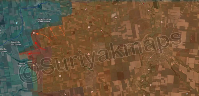
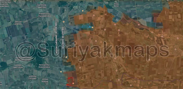
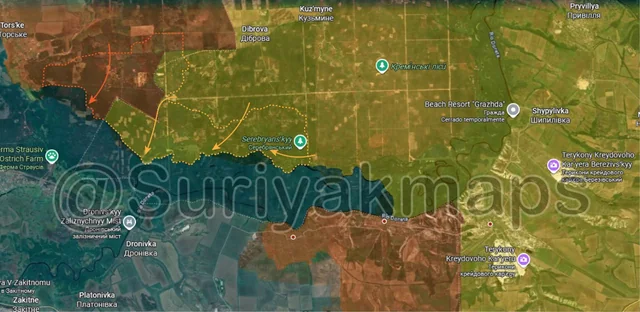
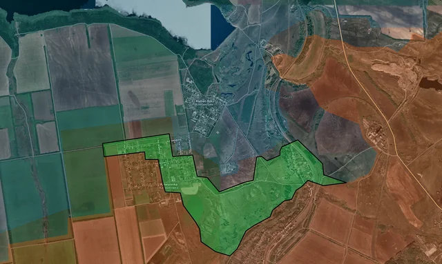
Back home
Post #213

RU POV: Russian and Ukrainian advances from Day 1273 to 1276 of the War - Suriyakmaps

Aug 19, 2025 — Aug 22, 2025 War Day 1273–1276

Make sure you read the dates for when these advances took place. This post will only cover events from last week, so some recent topics simply won’t be mentioned yet.

------------------------------------------------------------------------------------------------------

Pictures 1 to 4 are from Day 1273 (Tuesday 19 August), pictures 5 to 8 are from Day 1274 (Wednesday 20 August), pictures 9 to 12 are from Day 1275 (Thursday 21 August), and pictures 13 to 17 are from Day 1276 (Friday 22 August)

------------------------------------------------------------------------------------------------------

A reminder that these maps are confirming updates from previous days (i.e. typically 12 to 72 hours delayed from each day).

Ukrainian Advance
19.57 km²
Overall (set): 19.84 km²
Russian Advance
88.16 km²
Net Change
-68.59 km²

Situation Snapshots

Imagery, commentary, and territorial changes from the period.

19 entries
Ukrainian Forces Advance: 1.40 km²

Advance = 1.40km2

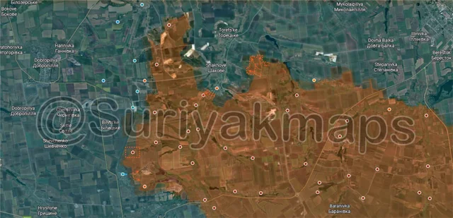
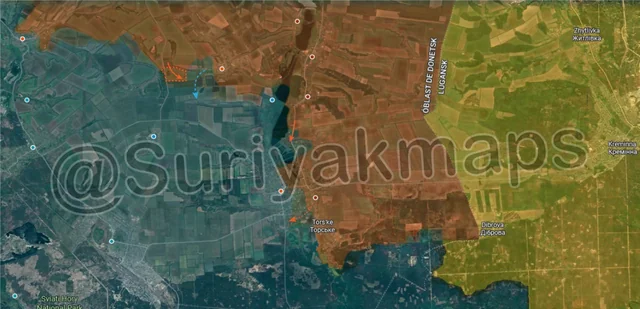
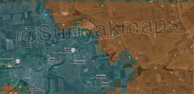
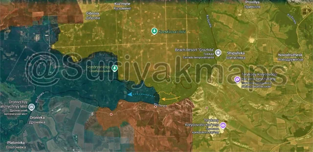
Today we’re starting in the Serebryansky forest, where the localised collapse continues to unfold. Over the past few days Russia has continued to clear the area north of the Siverskyi Donets River, taking over a number of positions to the north of Hryhorivka. Ukrainian forces are still scrambling back to the west, trying to avoid being cut off or overrun as there is no cohesive defence line currently.
Russian Forces Advance: 3.52 km²

Upper Right Advance = 2.55km2, Middle Advance = 0.56km2, Lower Left Advance = 0.17km2, Bottom Left Advance = 0.24km2

Heading to the Pokrovsk front, on the northeast side, Russian assault groups continue to work on pressuring the Ukrainian grouping in Shakhove, expanding their control of the treelines to the east of the small town, as well as taking over slightly more of Volodymyrivka. With the latter, some Russian sources say that the village is entirely under their control, whilst the Ukrainians maintain that they hold the entirety of the settlement.

Context
To the southwest (orange box) it was confirmed that Russia managed to hold Sukhetske, with the earlier Ukrainian attack failing. Slightly south of that, Suriyak has said that Russian troops have been driven out of Rodynske entirely, falling back to the mine. I do find this rather odd as many Ukrainian sources claim fighting is ongoing within Rodynske on the eastern side, so there is some confusion on whether Russian troops are still present.

Ukrainian Forces Advance: 17.26 km²

Top Advance = 5.11km2, Left Advance = 11.08km2, Bottom Left Advance = 1.07km2

On the western side of the Pokrovsk front, since early August Ukraine has gradually worked on recapturing the fields near the Donetsk-Dnipro Border, recapturing several treelines and pushing Russia back to Horikhove whilst they have been focused on advancing further south.

To the southwest on the Velyka Novosilka front, over the past 4 to 5 days Ukraine has continued their counterattacks east of Andriivka-Klevtsove, moving back into the fields and tree plantation. There is a lot of confusion over this area (as you’ll see further down) due to a mess of geolocations and conflicting reports.

A little to the south, Ukraine has launched a counterattack towards the small village of Oleksandrohrad, where clashes are taking place. Russia was not entrenched here despite their earlier claims, so Ukraine is trying to push them back out of the settlement before they can properly secure it.
Russian Forces Advance: 6.17 km²

Advance = 6.17km2

Down to the far eastern side of the Hulyaipole front, Russia has continued their opportunistic advance northeast of Olhivske discussed last post, seizing several fields and treelines. The village sis on the opposite side of a small stream and whilst it is certainly possible Russia may try capture it they will likely do so from their positions to the southeast rather than the area of this advance.
Ukrainian Forces Advance: 0.91 km²

Advance = 0.91km2

Over to the Oskil River front, west of Kolodyazi, the last clashes of the fighting in the village are now wrapping up, with Ukraine losing control over the western houses and Russia making a small push to the west of the settlement, which would have cut Ukraine off had they still tried to hold Kolodyazi. Russian troops are conducting clearing operations on the western side now, so should confirm control of the settlement within the next couple of days.

Further south, Russian assault groups continue to pressure Zarichne, forcing Ukraine to withdraw from the fish farm to the north and also crossing in a new spot on the south side of the town. Ukraine has been launching some smaller counterattacks to try drive Russia out, but has not had any success so far.
Russian Forces Advance: 4.70 km²

Top Middle Advance = 0.68km2, Top Right Advance = 4.02km2

Moving down to the Chasiv Yar front (quickly becoming the Kostyantynivka front), Russian assault groups slightly expanded their control along the T0504 road into the city, taking over a chunk of the forest area to its north. As mentioned in the previous post, the Russian control immediately south of this advance is questionable as more reliable sources claimed Russia is primarily pushing on the north side of the road (as shown here). Some Russian infantry groups reportedly got as far as the eastern edge of the city, but had to withdraw and wait for Ukrainian positions to be further softened up by FABs and artillery.

To the east, Russia has reportedly taken the last part of the canal and the Pivdenno-Skhidnyi mine, as Ukraine is forced to withdraw back into Kostyantynivka. I’ll note some sources claim Russia hasn’t cleared this yet and it is actually greyzone, but there does at least seem to be consensus that Ukraine no longer holds this area.

Russian Forces Advance: 6.49 km²

Top Left Advance = 3.30km2, Top Middle Advance = 2.05km2, Upper Left Advance = 1.14km2

Following on from picture 3, clashes were reported on the eastern side of Andriivka-Klevtsove, with Russian forces allegedly still present in the town. This is what I meant by “a lot of confusion” under picture 3, as sources are flip flopping on who controls what on this front. A large part of this is likely because both Russia and Ukraine have relatively few troops here compared to other ‘hot’ fronts, so there are more gaps in the line and it is easy for both sides to slip forces through as it is rather ‘porous’.

Immediately south of this, Ukraine has also been making moves towards Tolstoi (above the u), counterattacking into the southern part of the tree plantation.

To the northeast, Russian infantry cleared and capture some of the last treelines on the south side of the Vovcha River near Novokhatske. A few groups have also reportedly crossed the river here into the small forest area on the other side and are probing towards Filiya.
Russian Forces Advance: 13.52 km²

Upper Left Advance = 12.38km2, Middle Left Advance = 1.14km2

Down to the west side of the Velyka Novosilka front, over the past few days Russian assault groups made large gains near the Dnipro-Donetsk-Zaporizhia Oblast borders, seizing a number of fields and treelines, as well as capturing the small village of Novoheorhiivka. Interestingly, from what I’ve gathered from reports and footage from this front, many of these settlements do not seem to be occupied or manned by Ukraine at all, hence why Russia has been able to capture them with individual assault groups quite quickly. Ukraine is certainly still present, but they have are focusing on defending the northern Zaporizhia Defence line (dark blue) and conducting limited counterattacks.

Adjacent to this advance, another Russian group has been moving up the treelines north of Temyrivka, heading for Zapirzke.
Russian Forces Advance: 2.89 km²

Top Advance = 0.40km2, Bottom Left Advance = 0.64km2, Lower Left Advance = 1.85km2

Following on from picture 6, the Russian assault on Oleksandro-Shultyne continues, with their troops managing to cross the river and establish a foothold in the main part of the village.

To the southwest, after a few weeks of clashes Russian assault groups have managed to clear more of Katerynivka, now in control of about half the village, whilst Ukraine only maintains a tiny hold on the northeast side. Adjacent to this, other Russian groups have been working on northern Scherbynivka, capturing most of the remainder of the settlement. There is now only a couple of small streets of houses left to clear before Russia fully takes the town, but they will have to deal with Kleban-Byk first as the northernmost houses of Scherbynivka sit too close to that village.
Ukrainian Forces

No advance

Back to the west side of the Pokrovsk front, in Udachne, heavy clashes are ongoing between Russian and Ukrainian forces, with neither making any progress over the past couple of days.

To the southwest, one Ukrainian group has tried to cross the Solona River into Novomykolaivka, where they are attempting to establish a foothold. If successful, it would complicate Russian positions in the rest of the settlement as they would be wedged between that group and the Ukrainian forces in Muravka (just off bottom left of map).
Russian Forces Advance: 2.80 km²

Upper Middle Advance = 1.20km2, Lower Left Advance = 1.60km2

Following on from picture 6, Ukrainian forces continued to move through the tree plantation and back into Tolstoi. Despite their claims, they have not recaptured the village yet, only taking up positions in the western houses.

To the south, Russian forces recaptured the western houses and treeline in Maliivka, following a previous Ukrainian counterattack.
Russian Forces Advance: 2.51 km²

Advance = 2.51km2

Swinging around to the western side of the Zaporizhia front, over the past week Russian forces improved their positions in and around Kamyanske, recapturing the treelines and gully on the northeastern side of the town. They are still working on securing the settlement, but are in a much better positions compared to a few weeks ago when Ukraine was counterattacking back into Kamyanske.
Russian Forces Advance: 4.25 km²

Middle Advance = 3.08km2, Lower Right Advance = 1.17km2

Heading up to the Sumy front, Russian troops retook Varachyne and the surrounding treelines after a few days of clashes. There are so few positions to hold in this area that there is a high chance Ukraine may retake it once again, as neither side can really properly secure the village.

To the southeast, Russian assault operations in Yunakivka continue, with their troops managing to secure a few another set of houses on the south side of the town. Despite slow progress, Russia is gradually securing Yunakivka and unless there is a large Ukrainian counterattack in the near future the town will be secured by Russia.
Russian Forces Advance: 5.98 km²

Top Advance = 3.20km2, Bottom Advance = 2.78km2

Onto the Oskil River front, starting on the north side, Russian troops pushed back into the treelines south of Hrekivka. There has been a decent amount of back and forth here over the past month or two, so expect further attacks and counterattacks by both sides.

To the side, following on from picture 5, Russian assault groups secured the last bit of Kolodyazi and the adjacent treeline, establishing full control over the village. Russia can now make a wider push south, threatening Stavky and Zarichne (if that battle hasn’t ended by the time they get there).
Russian Forces Advance: 28.69 km²

Advance = 28.69km2

Following on from picture 1, over the past 3 days Russian forces made significant gains in the Serebryansky forest, clearing and capturing numerous positions across a wide area. As I mentioned 2 weeks ago, this localised collapse will continue at least until the Russians get to the Zherebets River (runs through Torske down through the forest and to the north of Dronivka), as that is realistically the only place Ukraine can reform the line.

At this point in time Ukriane only controls a thin strip north of the Siverskyi Donets River, with their forces trying to retreat back towards Yampil. Many aren’t so lucky, with a large amount of POWs (like this) taken and soldiers killed over the past 2 weeks as Ukrainian positions are outflanked and their infantry are isolated.

Russian Forces Advance: 2.43 km²

Top Right Advance = 0.09km2, Bottom Advance = 2.34km2

Context
To the southwest, more of Katerynivka has come under Russian control, as Ukrainian troops withdraw back into Kleban-Byk (blue dot below y) to try hold that village for as long as possible. Next to this the Russian troops in Scherbynivka also managed to capture most of the remaining houses in the town (leaving just a handful further north), as well as the trenches that sit north of the settlement. With pressure mounting and supplies restricted, it is highly unlikely Ukraine will be able to hold Kleban-Byk for long.
Russian Forces Advance: 4.21 km²

Advance = 4.21km2

To the southeast, Russian assault groups have been working on capturing the trenches and Kapitalna Mine to the west of Novoekonomichne over the past 2 weeks. As mentioned previously, Russia is closing in on Myrnohrad from multiple sides, but hasn’t actually made an attempt on the city yet. They likely intend to try get their forces as close as possible on multiple sides before beginning assault operations, aiming to overwhelm the Ukrainians with simultaneous attacks.