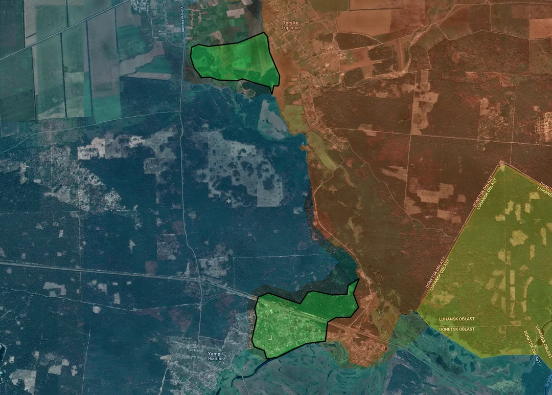
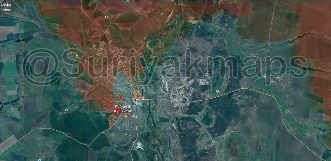
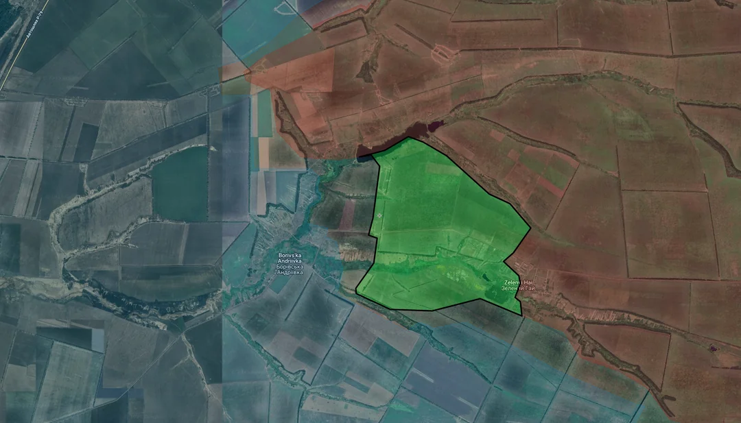
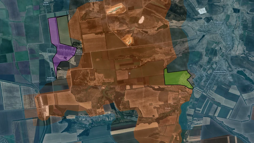
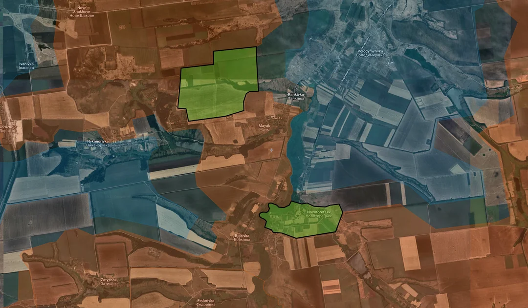
Back home
Post #223

RU POV: Russian and Ukrainian advances from Day 1313 to 1316 of the War - Suriyakmaps

Sep 28, 2025 — Oct 1, 2025 War Day 1313–1316

The September statistics post will go out shortly after this one.

------------------------------------------------------------------------------------------------------

Pictures 1 to 4 are from Day 1313 (Sunday 28 September), pictures 5 to 7 are from Day 1314 (Monday 29 September), pictures 8 to 12 are from Day 1315 (Tuesday 30 September), and pictures 13 to 15 are from Day 1316 (Wednesday 01 October).

------------------------------------------------------------------------------------------------------

A reminder that these maps are confirming updates from previous days (i.e. typically 12 to 72 hours delayed from each day).

Live map can be found here.

Ukrainian Advance
10.77 km²
Overall (set): 10.82 km²
Russian Advance
74.20 km²
Net Change
-63.43 km²

Situation Snapshots

Imagery, commentary, and territorial changes from the period.

21 entries
Ukrainian Forces Advance: 2.09 km²

Advance = 2.09km2

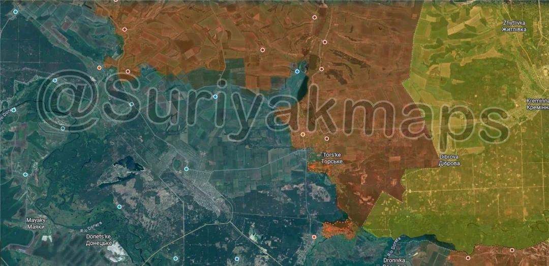
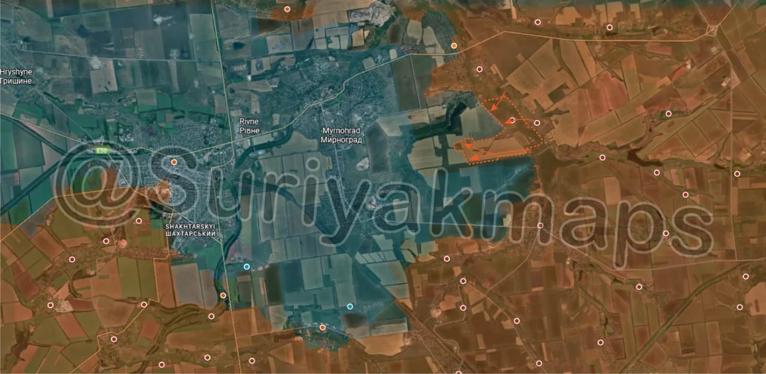
Kicking off this post on the Sumy front, over the past week Ukraine recaptured the rest of the fields and treeline on the southern side of the Kindrativka reservoir. This area has been in the greyzone since Russia lost control of Kindrativka a few months back and became unable to contest it, with Ukraine only recently moving in.
Russian Forces Advance: 3.41 km²

Lower Middle Advance = 1.39km2, Bottom Advance = 2.02km2

Russian Forces
Down to the Lyman front, slightly south of Zarichne, a Russian assault group crossed the Zherebets River on the southern side of Torske and took up positions on the northern edge of the forest. This group will be looking to enter southern Zarichne to clear the last part of the town out.

Further south, after a week of clashes Russian forces expanded their control of Yampil, capturing the railway station and the eastern side of the town. Heavy clashes are ongoing over the centre now, as Russia seeks to expand its control of the settlement.
Russian Forces Advance: 11.12 km²

Top Advance = 3.63km2, Upper Left Advance = 2.12km2, Middle Left Advance = 4.79km2, Bottom Advance = 0.58km2

On the Pokrovske and Hulyaipole fronts, Russia has continued making steady progress in their push west. Over the span of two days they expanded their control over the fields and treelines north of Stepove and Berezove (top two advances), whilst other Russian assault groups punched west from Kalynivske, managing to quickly break into Verbove and establish a foothold on the eastern side of the village. As with the other settlements on this front that I have talked about many times now, it is highly likely that Russia will capture the settlement within the next couple of days as Ukraine is unable to put up any coordinated defence.

A little to the south, there was also some smaller Russian advances in the treelines southwest of Novoivanivka, bringing them closer to the village of Novovasylivske.
Ukrainian Forces Advance: 1.14 km²

Advance = 1.14km2

Moving onto the Orikhiv front, Ukraine made a small advance in the treelines south of Mala Tokmachka, part of the positional battles ongoing in the area.
Ukrainian Forces Advance: 2.34 km²

Middle Advance = 1.76km2, Lower Left Advance = 0.58km2

Heading up to Kupyansk, on the west side of the town, over the past three days Russia has continued expanding their control, capturing houses in several more streets and sending smaller DRG groups deeper into the southern side. Ukraine has been conducting a lot of counterattacks and movements around western Kupyansk (video 1, video 2, video 3, video 4, video 5) but has only managed to stall Russia so far, not drive them back.

On the eastern side of the town, with nothing heard about the alleged Russian infiltration deep into the industrial area for two weeks now Suriyak has marked it back as Ukrainian control (was greyzone). I personally never saw any evidence that it occurred, just many vague claims, so I am not sure what, if anything, happened there.
Ukrainian Forces Advance: 4.35 km²

Top Advance = 0.21km2, Upper Advance = 4.14km2

Down to the Siversk front, over the past two weeks Russia has intensified their attacks southeast of the town, gradually clearing out the many small dugouts and trenches that litter the landscape. Whilst this isn’t a particularly large advance, Ukraine is steadily losing its positions all around Siversk and Russia is closing in on multiple sides, so the town is in increasing danger of being assaulted or cut off.
Ukrainian Forces Advance: 0.85 km²

Top Advance = 0.85km2,

Northeast of Pokrovsk, the situation around the Russian salient is still an absolute clusterfuck. On the north side, the Russians continue pushing north and northwest, trying to cut off the Ukrainian salient by reaching or bypassing Sofiivka.

To the south, Ukraine has been active in the fields and treelines east of Novotoretske, trying to expand control of the flanks and recapture some fortifications in that area.

Clashes continued in Nykanorivka to the west, although the situation there is unclear so I would not put much trust in any arrows or marked territory for the moment.
Russian Forces Advance: 6.41 km²

Advance = 6.41km2

Context
Up to the Oskil River front, east of Borivska Andriivka, Russian forces have been gradually chipping away at the fortifications near the village, capturing several trench networks and forcing the Ukrainians to withdraw back into the settlement.
Russian Forces Advance: 12.41 km²

Lower Middle Advance = 9.00km2, Bottom Advance = 3.41km2

Following on from picture 2, after another 2 days of fighting Russian forces cleared and captured the last part of Zarichne, confirming full control of the town. They also captured some of the adjacent forest area to the south, which they will likely use to push out further west and southwest.

As Suriyak mentioned, this puts Russia just 6km from Lyman, the Ukrainian logistics hub in the area and a core part of their defence of northern Donetsk Oblast. Whilst there are no settlements in the way on the east side of Lyman for Russia to reach the town, they are almost certainly not going to make a direct push on it right now as they need reliable logistics routes and secure flanks for the battle, which will require them to capture Yampil and more of the forest.

Speaking of, south of the previous advance, Russian forces are expanding their control of the forest next to Yampil as Ukraine is forced back deeper into the town.
Russian Forces Advance: 14.75 km²

Advance = 14.75km2

Moving back to the Siversk front once again, this time on the northern side where the situation has continued to deteriorate for Ukraine. Over the past few days Russian forces have managed to capture the fields south and west of Serebryanka, taking over the fortifications and old mine that sits on the hill above Siversk itself. They have also pushed west to clear and capture Rudnik, a satellite suburb of Siversk, as well as moving into the adjacent quarry.

Whilst these positions are only lightly held (not enough cover to bring many troops in), it does present serious problems for Ukraine. Whilst it is highly unlikely Russia will try head straight down the hill and into northern Siversk, Ukraine is now stuck with fewer viable routes to move troops and supplies around. Of more concern is the area to the northwest, where Russia is closing in on Dronivka from the north (over the river) and the east. If Dronivka falls, Russia will be able to bypass Siversk and push straight for the main supply road for the town, leaving them with only the other, more exposed route near Sviato-Pokrovske.
Russian Forces Advance: 4.47 km²

Middle Left Advance = 2.97km2, Bottom Left Advance = 1.50km2

Context
Following on from picture 7, on the west side, the Ukrainian counterattack from a few weeks ago was confirmed to have failed (around the same time), meaning Russia still control the treelines north of Mayak.

Slightly south of this, Russian forces regained control over central Novotoretske following several Ukrainian attempts to infiltrate and assault the village, although the northern houses remain under Ukrainian control.
Russian Forces Advance: 0.82 km²

Advance = 0.82km2

Context
Following on from picture 3, in the previous post I mentioned I wasn’t sure the Russians would hit Poltavka head on (east), however they have indeed made a push straight into the settlement, taking over the first few houses and establishing a small foothold. Part of the reason I was uncertain was due to Russian efforts further south in Malynivka and the existence of the Yanchur River, which splits Poltavka in two, but the Russians seem confident they will be able to cross it without much issue.
Russian Forces Advance: 2.74 km²

Far Left Advance = 1.69km2, Middle Left Advance = 1.05km2

Context
Following on from picture 11, on the western side, Ukraine reportedly recaptured Nove Shakhove and one of the adjacent fields yet again after over a week of clashes. However, the Ukrainian counterattack immediately south to try bypass Dorozhnje was not so successful, with both IFVs knocked out and destroyed (video 1, video 2). I mentioned this last post, but I believe both Dorozhnje and Nykanorivka should be marked greyzone instead of Russian and Ukrainian controlled respectively, as its clear neither side properly controls either settlement.

To the east of this, Russia has been launching counterattacks of its own into Pankivka, managing to retake some houses and one of the trench networks.
Russian Forces Advance: 4.37 km²

Advance = 4.37km2

A little further south on the same front, over the past week Russia has been sending small numbers of infantry into the fields and treelines east of Myrnohrad, up to one of the mine ventilation shafts. This is being done in order to try clear the area for possible probing attacks or DRG movement towards Myrnohrad, but this area has changed hands frequently so it is hard to say whether Russia will hold these buildings this time.
Russian Forces Advance: 9.61 km²

Top Left Advance = 0.31km2, Upper Left Advance = 2.42km2, Middle Advance = 2.50km2, Lower Middle Advance = 1.73km2, Bottom Advance = 2.65km2

Following on from picture 12, on the north side, Russian assault groups cleared and captured the remainder of Verbove, confirming full control of the village. They have already been shelling Vyshneve (next village west), with some Ukrainian sources suggesting Russia is planning to make another quick thrust along the road into the settlement like they did with Verbove to try capture it before Ukraine can reorganise. Despite how risky this is, there is some merit to these claims as satellite imagery has shown traces of fighting and shelling all along the road up to Vyshneve.

Further south, Russia expanded control over the fields west of Novoivanivka once again, levelling the frontline somewhat.

Moving south again one last time, Russian forces captured more of the fields and treelines east of Poltavka as fighting began in the village, as well as slightly expanding their foothold within the settlement. The eastern side will certainly fall to Russia, but the main question is now whether they can cross the Yanchur River by foot and take the rest of Poltavka.
Russian Forces Advance: 4.09 km²

Lower Left Advance = 4.09km2

From Picture 7