Back home
Post #228

RU POV: Russian and Ukrainian advances from Day 1331 to 1334 of the War - Suriyakmaps

Oct 16, 2025 — Oct 19, 2025 War Day 1331–1334

Pictures 1 to 6 are from Day 1331 (Thursday 16 October), pictures 7 to 13 are from Day 1332 (Friday 17 October), pictures 14 to 16 are from Day 1333 (Saturday 18 October), and pictures 17 to 20 are from Day 1334 (Sunday 19 October).

------------------------------------------------------------------------------------------------------

A reminder that these maps are confirming updates from previous days (i.e. typically 12 to 72 hours delayed from each day).

Ukrainian Advance
7.53 km²
Overall (set): 6.01 km²
Russian Advance
143.63 km²
Net Change
-136.10 km²

Situation Snapshots

Imagery, commentary, and territorial changes from the period.

20 entries
Russian Forces Advance: 3.03 km²

Advance = 3.03km2

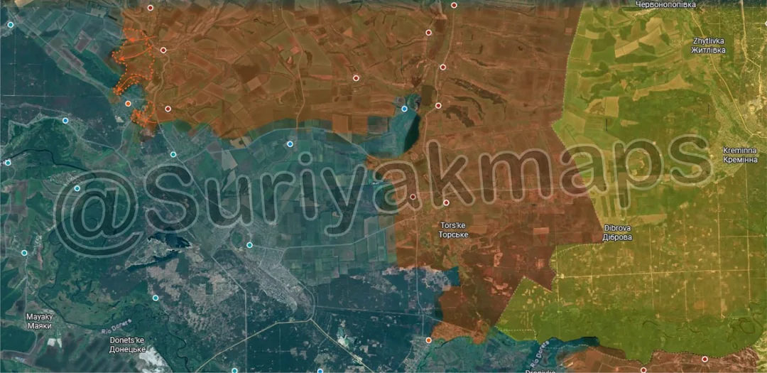
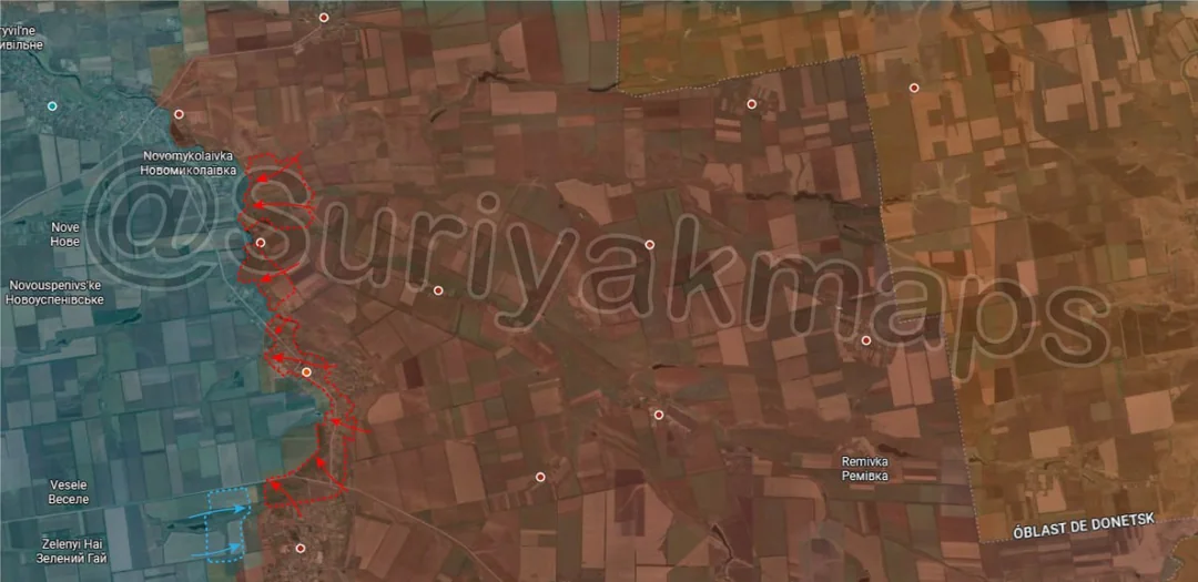
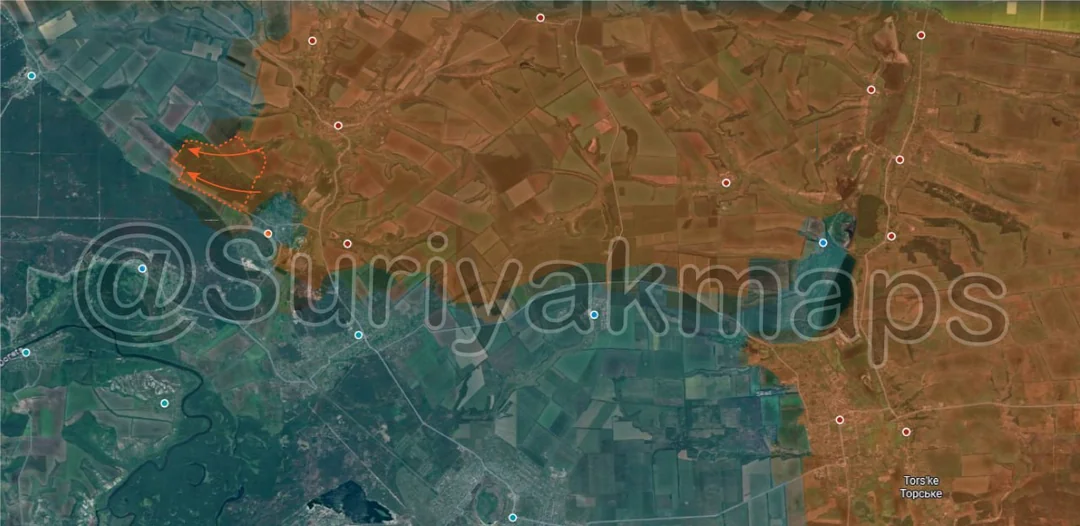
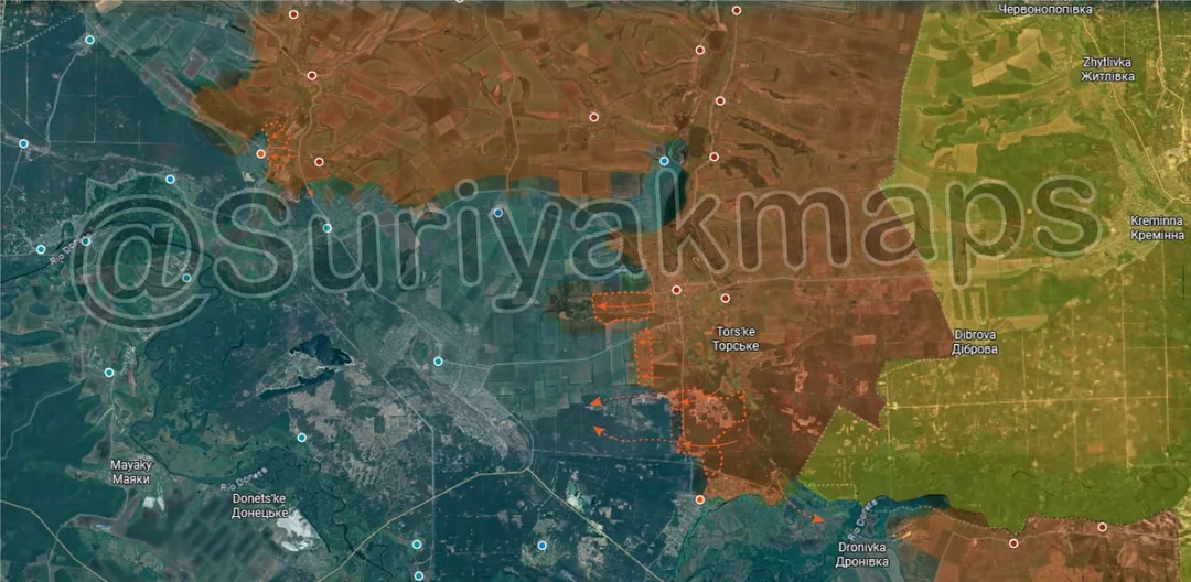
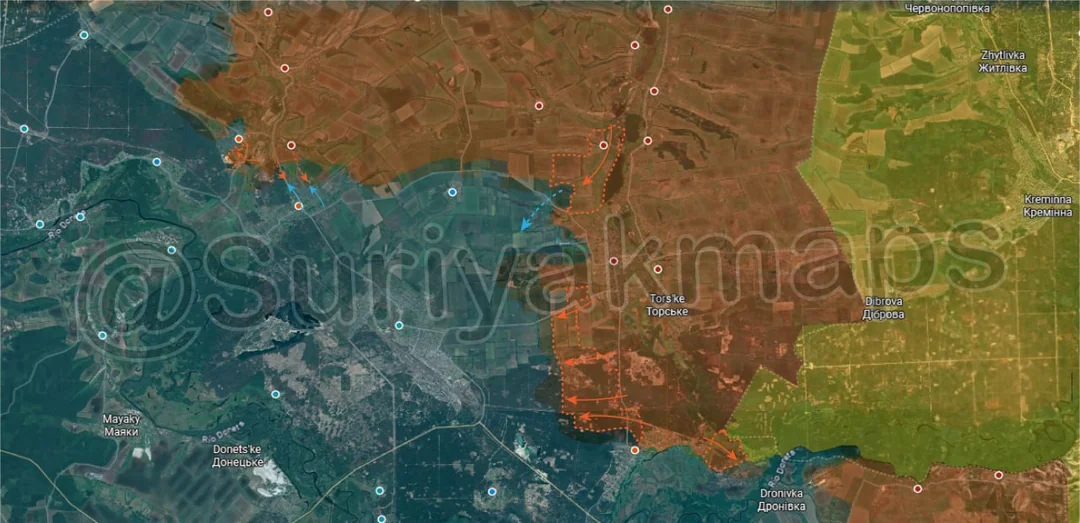
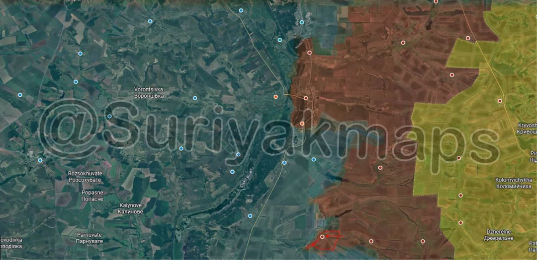
Kicking off today we’re on the Oskil River front, where after a few weeks of positional battles Russian troops captured the village of Borivska Andriivka. The capture of the nearby trench networks and Zelenyi Hai allowed the Russians to close in on the settlement and clear out the last of the Ukrainian defenders.

Whilst this advance does technically mean Russia could head straight for the Ukrainian supply hub of Borova (as there are no more settlements left inbetween them and the town) they almost certainly won’t as the route is too open and vulnerable to counterattack. The Russians will likely try push west towards Novoplatonivka (below the y) using the gulley next to Borivska Andriivka in order to pressure the partial pocket that has formed against the Oskil River. The other option would be to ignore Borova and head south towards Shyikivka (off map) to try create a new pocket of the last Ukrainian positions in Luhansk Oblast.
Russian Forces Advance: 6.60 km²

Top Left Advance = 5.57km2, Upper Left Advance = 1.03km2

Further south on the same front, the Russians made large gains around the small town of Novoselivka. On top of securing the large area of fields and treelines next to Shandryholove, they were also able to capture part of the forest northwest of Novoselivka (which they have been bombarding for weeks), as well as re-entering the town from the southwest side. At this point the settlement is being attacked from three different sides and stands little chance of holding out.
Russian Forces Advance: 2.37 km²

Top Advance = 1.48km2, Upper Left Advance = 0.75km2, Bottom Left Advance = 0.14km2

Heading over to the Kostyantynivka front, over the past week the Russians closed in on the city from the east, moving downhill past the village of Predtechyne (half Russian controlled, half greyzone), as well as securing the last of the dachas a little south of that. Some Russian DRG groups have already been reported in Kostyantynivka, but it unclear where they were or how far into the city they were able to get before being found.

To the south, whilst the Russians are pressuring Ivanopillya from the east, Ukraine counterattacked in Pleshchiivka and managed to recapture the southern houses. Clashes are continuing however as the Russians still have a firm presence in neighbouring Nelipivka.

Russian Forces Advance: 14.01 km²

Advance = 14.01km2

Moving onto the Novopavlivka front, after the capture of Filiya the previous week the Russians pushed out into the surrounding area, capturing a number of fields and treelines. This has created a small pocket above Dachne (above the a), which Ukraine will likely be forced to abandon if the Russians push any further from either side.
Russian Forces Advance: 11.46 km²

Advance = 11.46km2

Over on the Pokrovske front, Russian assault groups from Verbobe managed to force their way through Ukrainian lines to the southwest, capturing a number of fields and treelines, reaching and capturing the small village of Pryvyillya. This puts Russia right up against the Yanchur River in yet another area, further straining the Ukrainians who are struggling the hold the line along said river.

Whilst this does put them on the southern flank of Vyshneve, they are unlikely to try attack it from Pryvillya due to the lack of cover and how exposed the attack would be. Instead they may try cross the Yanchur River here (to pressure neighbouring villages which supply Vyshneve) or focus on securing the surrounding area.

Russian Forces Advance: 10.88 km²

Upper Left Advance = 2.62km2, Middle Left Advance = 1.18km2, Lower Left Advance = 4.68km2, Bottom Left Advance = 2.40km2

Slightly south on the Hulyaipole front, over the past week Russian assault groups have made large advances all along the Yanchur River. From the top down, they captured the remaining fields and treelines on the east side of the river near Okhotnyche, providing Russia more places to cross (Yanchur River is quite thin here).

A little south of that, Russian forces captured most of the village of Poltavka as well as the fields and small forest area immediately south of it. Not only does this link Malynivka (bottom red dot) to Poltavka, but it also means Russia now has a 9km wide bridgehead over the Yanchur River.

Adjacent to this, Ukraine launched a counterattack west of Malynivka, trying to push back into the village. They were able to capture several fields and treelines, but only reached the outskirts of the settlement.
Russian Forces Advance: 7.31 km²

Top Right Advance = 4.58km2, Lower Left Advance = 2.73km2

Swinging all the way up to northern Kharkiv, in and around Vovchansk Ukrainian defences fell apart. Following on from the earlier successes, Russian assault groups wasted no time pushing deep into southern Vovchansk, capturing several more streets, the cemetary and entering the industrial zone on the southern edge of the town (the main Ukrainian ‘stronghold’).

As for the northern side of Vovchansk, whilst Suriyak has marked some large Russian advances only part of these are new. All of the town centre north of the Vovcha River has in my opinion been under Russian control for a long time now, with Ukraine not seen in that area for many many months. The area east of this is a new advance though, with Russian forces recapturing the village of Tykhe after Ukraine was forced to withdraw back over the river. The Russians have also reportedly crossed the Vovcha in eastern Vovchansk and are starting to clear the streets there, where they will eventually link up with the other assault groups to the southwest.

I would not call this a localised collapse (yet), just a failing of the Ukrainian garrison resulting in them being forced out rather quickly. Russia didn't redeploy any forces to this area recently, so it has been the same units operating here for months now. For Ukraine it's the same, but that is the core issue. Ukraine needed more forces here as the existing units were getting worn down by drone strikes, artillery, etc. whilst the Russians slowly probed and pushed, growing more confident over time as they weeded out Ukrainian positions and destroyed equipment. They needed to reinforce this area and rotate their troops, but because of the intense fighting on other fronts (Pokrovsk, Kostyantynivka, Kupyansk) there was no one they could send. Some areas draw the short straw as Ukraine has to prioritise the resources they have and in this case it was Vovchansk.
Russian Forces Advance: 1.39 km²

Advance = 1.39km2

Over in Kupyansk, Russia has continued working away at the small pocket in the town’s centre, clearing out most of it (bar some stragglers). Ukraine is still present in the settlement and is still trying to counterattack, but have not had much success so far due to how disjointed their forces are.
Russian Forces Advance: 5.89 km²

Advance = 5.89km2

Further east on the same front, Russian assault groups pushed up along the railway line and managed to capture the village of Pishchane (video 1, video 2). Russia will need to capture the surrounding area if they wish to properly secure Pishchane, as the Ukrainians are likely to counterattack from Kurylivka (west, along the same railway line).
Russian Forces Advance: 3.93 km²

Advance = 3.93km2

Following on from picture 2, Russian assault groups captured most of the remainder of the forest area (Sviati Hory National Park) next to Novoselivka, providing them even more cover in the area and further isolating Novoselivka. Russians sources have also claimed that some groups crossed the fields south of this advance and entered the large national park, but that hasn’t been confirmed at this time.
Russian Forces Advance: 9.20 km²

Advance = 9.20km2

Onto the Siversk front, as mentioned/predicted a few weeks ago, Russian forces from Vyimka (underneath the i) and Pereizne (under the S) have pushed towards each other, squeezing Ukraine out of the fortifications and fields between the villages. This straightens the frontline in this area and will make it much easier for Russia to assault Zvanivka (eventually) due to having a wider range of attack angles.
Russian Forces Advance: 0.36 km²

Advance = 0.36km2

Following on from the previous post, Russia captured more of the dugouts and mini trenches along the canal south of Novomarkove, building up positions for a possible attack on the village.

Russian Forces Advance: 8.25 km²

Top Right Advance = 6.00km2, Lower Left Advance = 0.47km2, Lower Middle Advance = 0.41km2, Lower Right Advance = 1.37km2

Heading to the Pokrovsk front, Ukrainian positions in and around the cities have severely deteriorated in recent days. On the northeast side, Russian assault groups recaptured the slag heap and most of the remainder of the Kapitalna Mine, once again putting them right on the outskirts of northeastern Myrnohrad.

To the south, with the Russian entry into the southern suburbs of Myrnohrad other nearby forces have become active, starting to move into the treelines around Mykolaivka. If Russia can secure a foothold in the southern side of the city they will be able to use these treelines to bring in more forces from Novohrodivka (town to the south), rather than the more open routes to the east.

Within Pokrovsk itself, Russian assault groups have become much more active and have broken through the Ukrainian defences across most of the west and central parts of the city. On top of securing more highrises and crossing the E50 highway in southern Pokrovsk, some Russian forces have even reached the railway area, leading to Suriyak marking a large area as greyzone (white shape) due to the chaos unfolding. Ukraine’s supply and manpower issues have weakened them to the point where they are no longer able to hold a solid line, so the Russians have gotten behind them in many areas and are regularly ambushing or capturing isolated soldiers as they move deeper in.

Of greatest concern though is the northwestern edge of Pokrvosk, where both the E50 highway and road from Hryshyne converge in the industrial area. If this industrial area falls Ukraine will lose access to 2 of its supply routes, leaving a very narrow route north of the cities for all supply and troop movements to occur through, all at high risk of being hit by drones and artillery.
Russian Forces Advance: 12.11 km²

Top Left Advance = 1.42km2, Middle Advance = 2.98km2, Lower Middle Advance = 1.40km2, Bottom Advance = 6.31km2

Following on from picture 10, Russian assault groups captured the northeast section of Novoselivka and are currently pushing deeper into the town.

To the southeast, over the past week Russian troops have made several advances around Zarichne, moving into the fortifications west of the town in the forest area, as well as capturing more of the forest north of Yampil (bottom red dot). Russian DRG movement has also been reported much further west, as they are probing Ukrainian defences closer to Lyman.
Ukrainian Forces Advance: 7.53 km²

Left Advance = 5.05km2, Middle Left Advance = 2.48km2

Over on the salient northeast of Pokrovsk, the Russians have once again pushed back into Nove Shakhove on the west side. Neither Ukraine nor Russia is able to get a solid grip on any of this villages, so we are stuck in a constant back and forth.

East of that, following the Russian mechanised attacks over the past week the Ukrainians have counterattacked, resecuring the eastern outskirts of Shakhove and trying to push back into Voloymyrivka, taking the northern houses.
Russian Forces Advance: 2.72 km²

Left Advance = 0.99km2, Right Advance = 0.61km2, Bottom Right Advance = 1.12km2

Following on from picture 13, Russian presence and control of Pokrovsk has only grown over the span of a day, with their troops starting to clear the central highrise area now (orange advance) as well as sending assault groups deep into the industrial area to the northwest and all throughout the centre of the city.

Out west, Ukraine was able to resecure the eastern buildings of the coking coal mine north of Udachne, where they are again digging in. Russia has gone back to heavily bombarding this area in preparation for the next attack.
Russian Forces Advance: 25.85 km²

Top Left Advance = 0.51km2, Upper Middle Advance = 8.71km2, Lower Middle Advance = 13.62km2, Bottom Right Advance = 3.01km2

Following on from picture 14, on the northwest side, Russian assault groups further expanded their control of Novoselivka, capturing the southeastern quarter of the town. Many sources report that the entire town is under Russian control at this point, but Suriyak seems to be waiting for confirmation of control over the central and southwestern parts of the settlement. I will also mention that some Russian sources claim they have broken into neighbouring Drobysheve where clashes have commenced, so keep an eye out for movements in that area.

To the east, Russia finally captured the village of Myrne and the adjacent fortifications after a long period of bombardment and several assault attempts (although several sources claim it was captured a little while back). This wraps up the little pocket that had formed along the Zherebets, meaning Russia can now focus on a push on Lyman.

To the south, the previously mentioned Russian DRGs and assault groups have further expanded their control of the forest north of Yampil and are fast approaching the key town of Lyman. Ukraine seems to have fallen back to the defence line that runs around Lyman (from the northwest to southeast of the town), but this line is not particularly dense and will not hold up long if the Russians try to smash through it in the forest.
Russian Forces Advance: 6.28 km²

Top Right Advance = 2.08km2, Middle Advance = 2.22km2, Middle Right Advance = 0.05km2, Right Middle Right Advance = 0.36km2, Lower Right Advance = 0.51km2, Bottom Left Advance = 1.16km2

Following on from picture 16, to the northeast, Russian assault groups pushed deeper into Rodynske and are assaulting the central highrise area now. If the town falls it will give Russia a solid base of operations for the northern flank and allow them to cut off Ukrainian supplies from that area.

Within Pokrovsk, more of the city has fallen to the Russians, with most of the western suburbs, the central highrise area and the southern industrial area coming under their control. Ukraine is trying to stabilise but their lines are too thin and the chaos is making it difficult to coordinate and set up a new line.

Out west, the Russians restarting operations along the Dnipro and Donetsk Oblast border, pushing into the village of Molodetske and taking over half of it (small village, wasn’t manned).
Russian Forces Advance: 10.73 km²

Left Advance = 6.50km2, Middle Left Advance = 1.84km2, Lower Left Advance = 1.19km2, Bottom Left Advance = 1.20km2

Following on from picture 5, the Russian assault groups that captured Pryvillya decided to do a mix of the 2 options I mentioned earlier, both expanding their control of the fields south of the village, but also sending at least one infantry group over the river into Zlahoda. They will need more forces if they wish to properly secure the settlement, but it does show Russia has the ability to cross the Yanchur River in more areas.

Further south, on top of beginning the assault on the large farm south of Novohryhorivka, the Russians unexpectedly crossed the Yanchur River next to Novovasylivkse and entered the village of Novomykolaivka. Interestingly, whilst Suriyak and some Ukrainian sources say they rapidly captured the settlement, the chief Russian source for this front (Voin_DV) denies this and says they are still working on clearing it. I do agree with the Russians here as it seems far too quick in this case (less than a day from crossing to reported capture) and they have the biggest incentive to back the claim if it were true.
Russian Forces Advance: 1.26 km²

Left Advance = 1.02km2, Lower Left Advance = 0.24km2

Following on from picture 6, the Russians secured the last couple of houses in Poltavka, confirming full control over the village. They have already begun to push out west, trying to expand the buffer around the settlement and push forward before Ukraine can regroup.