Back home
Post #232

RU POV: Russian and Ukrainian advances from Day 1341 to 1344 of the War - Suriyakmaps

Oct 26, 2025 — Oct 29, 2025 War Day 1341–1344

Another phone post, I’m getting there with the backlog.

Would be really handy if they could call a timeout for a few days to give me a chance to catch up.

------------------------------------------------------------------------------------------------------

Pictures 1 and 2 are from Day 1341 (Sunday 26 October), pictures 3 to 10 are from Day 1342 (Monday 27 October), pictures 11 to 13 are from Day 1343 (Tuesday 28 October), and pictures 14 to 18 are from Day 1344 (Wednesday 29 October).

------------------------------------------------------------------------------------------------------

A reminder that these maps are confirming updates from previous days (i.e. typically 12 to 72 hours delayed from each day).

Ukrainian Advance
9.67 km²
Overall (set): 9.67 km²
Russian Advance
80.58 km²
Net Change
-70.91 km²

Situation Snapshots

Imagery, commentary, and territorial changes from the period.

18 entries
Russian Forces Advance: 1.31 km²

Upper Left Advance = 0.35km2, Middle Left Advance = 0.96km2

For once we start a post on the Pokrovsk front, right in the centre of the city. Russian forces have finished securing the remaining streets in the centre of the city and have also expanded their control north of the railway. At this point in time about 55% of Pokrovsk is under Russian control, with more being captured each day.
Russian Forces Advance: 2.22 km²

Advance = 2.22km2

On the Pokrovske front, Russian troops began their assault on the large village of Vishneve, where Ukraine dug in heavily (a few weeks back). With other Russian troops flanking their supply route to the south (see last post) and being bombarded heavily, the garrison is unlikely to be able to hold.

At least one other Russian group in this area was operating separately to the assault on Vyshneve, moving up the treelines and reaching the outskirts of Novooleksandrivka.
Russian Forces Advance: 2.76 km²

Middle Right Advance = 0.35km2, Bottom Left Advance = 0.69km2, Bottom Middle Advance = 1.72km2

Swinging all the way up north to the northern front, over the past couple of days Russian forces continued to gain ground across the area, capturing more of the forest near Prylipka (likely empty), and capturing the village of Synelykove. They will likely try to keep their momentum up in this area by attacking neighbouring Tsehelne (small village), before moving on south to the village of Lyman (off map).

Northeast of this, the other Russian push within Vovchansk continues, with their forces capturing more of the industrial district, up to the southwest road.
Russian Forces Advance: 9.43 km²

Middle Advance = 2.98km2, Lower Middle Advance = 4.02km2, Bottom Right Advance = 2.43km2

Over on the Lyman front, the battle for the town has entered its early stages, with Russian assault groups capturing more of the adjacent forest areas and moving deeper into the settlement. I’ll also note that Lyman is also having supply issues, with the Russians taking out the pontoon bridge over the Siverskyi Donets River last week, and disrupting Ukrainian attempts to fix it.

North of this, other Russian forces expanded their control of the forest area outside Zarichne and will be able to threaten the rear of Stavky if they keep pushing west (assuming Ukraine still holds it at that point).

To the south, Russian forces reportedly advanced within Yampil, although some sources claim this is only DRG movement and that most of the settlement is in the greyzone.

Russian Forces Advance: 13.22 km²

Advance = 13.22km2

Heading to the Kostyantynivka front, after a few weeks of inactivity Russia was confirmed to have cleared the large area of fields and the small forest south of the Kleban-Byk Reservoir. This area had been abandoned by Ukraine earlier due to the risk of encirclement, but it took a while for the Russians to actually move in and check for stragglers. Some forward Russian groups are already heading around the east and west side of the reservoir to try take control of the northern forest.
Ukrainian Forces Advance: 7.86 km²

Advance = 7.86km2

Back to the Pokrovsk front, this time on the northeast side where Ukraine’s counterattacks continued. Their troops were able to retake a few quarries east of Nove Shakhove and are now threatening the Russian push into western Shakhove.
Russian Forces Advance: 1.78 km²

Top Middle Advance = 0.15km2, Top Right Advance = 0.47km2, Upper Left Advance = 0.47km2, Middle Right Advance = 0.69km2

Following on from picture 1, Russian assault groups were confirmed to have entered the northern side of Myrnohrad, whilst other groups on the southern side expanded their existing foothold.

To the west in Pokrovsk, Russian forces continue to secure more of the industrial area on the northwestern side of the city, now firmly in control of most of it. If Russia can build up its forces in this area and push north any hope of Ukraine relieving the trapped garrison will be lost, as the exit route will simply be too small and exposed.
Russian Forces Advance: 16.61 km²

Top Left Advance = 1.68km2, Left Advance = 5.46km2, Lower Left Advance = 9.47km2

Following on from picture 2, on the north side, the Russian push towards Novooleksandrivka was confirmed, with assault groups now fighting for the village.

Southwest, other Russian infantry groups made a locally significant advance, managing to secure a strong foothold on the west side of the Yanchur River, capture the village of Yehorivka and also push out into the surrounding fields. This not only cuts off the supply route to Vyshneve (for the remaining Ukrainian garrison), but gives Russia a straight shot west to Danylivka and the Hulyaipole supply road. Speaking off, it seems to have gone under the radar but the supply road has not been a viable route for over a week now due to Russia taking out the bridge linking Pokrovske to Danylivka.

Further southeast, other Russian groups continue to clear the last remnants of Ukrainian control east of the Yanchur, taking over a large area of fields and the village of Pryvilne.
Russian Forces Advance: 5.15 km²

Advance = 5.15km2

A little south on the Hulyaipole front, Russian forces have continued working to expand the buffer around Poltavka, capturing the nearby fields and treelines.
Russian Forces Advance: 1.09 km²

Advance = 1.09km2

Out west on the Zaporizhia front, as part of the ongoing positional battles some Russian groups managed to push deeper into Prymorske, capturing a few more streets of houses. There is a ton of back and forth in this area so these positions are rather fragile and control could change quickly.
Russian Forces Advance: 3.48 km²

Left Advance = 2.19km2, Middle Left Advance = 1.29km2

Following on from picture 4, Russia further expanded its control of the forest southeast of Lyman, capturing the area north of the quarry. There is a possibility here that Russia may try cut south to assault Dibrova, thereby cutting Yampil and the surrounding areas off from Lyman.

Over to the east, over the past few days Russian assault groups finished clearing the remainder of Dronivka, now in full control of the settlement. They will likely be preparing to push to Platonivka to further isolate the Ukrainian garrison in Siversk.
Russian Forces Advance: 1.71 km²

Top Right Advance = 1.12km2, Upper Middle Advance = 0.59km2

Back to the Kostyantynivka front, this time east of the city. Russian DRGs have expanded their operations in the eastern suburbs, establishing a small foothold right on the edge of the settlement and adventuring deeper into the city, probing Ukrainian defences. This is all being done in preparation for a proper assault on Kostyantynivka, which could occur in the coming weeks if Ukraine cannot reestablish the defences around the city.

To the east, Russia also recaptured some of the fields east of Predtechyne, gradually securing the pocket and rear areas to improve their positions around Kostyantynivka.
Russian Forces Advance: 1.47 km²

Upper Right Advance = 0.08km2, Middle Advance = 0.21km2, Middle Right Advance = 1.18km2

Following on from picture 7, Russian troop numbers in Pokrovsk continue to climb as more forces are brought into the city, who have also been working to clear out rear areas for any remaining Ukrainian soldiers who were unable to flee north. They have also moved across Shoseina street and are now clearing the eastern suburbs (Rih and Hnativka).

In neighbouring Myrnohrad, the capture of Balahan was confirmed (likely occurred days back) and Russian troops landed in yet another part of the city, moving into the central highrise area. This makes it the fourth foothold in the city that Russia has established, as Ukrainian defences buckle as their troops try to flee.
Russian Forces Advance: 0.12 km²

Advance = 0.12km2

Up in Kupyansk, over the past week the Russians have continued combing the western side of the town, expanding their control of the south side slightly and moving further into the southern apartment district.
Russian Forces Advance: 7.10 km²

Very Top Advance = 0.88km2, Top Advance = 4.86km2, Upper Left Advance = 0.25km2, Left Advance = 1.11km2

Heading to the Siversk front, on the west side, Russian assault groups that entered Zvanivka a few days prior have established a foothold in the village, taking over the southern streets. They are currently trying to work their way north as clashes continue over the central part of the settlement.

To the northeast, Russian infantry groups have continued their gradual clearing of Ukrainian dugouts and fortifications around Siversk, capturing more of the railway, fields and treelines east and south of the town. They are certainly closing in on Siversk and will reach the southern streets soon if Ukraine does not respond.

Ukrainian Forces Advance: 1.81 km²

Advance = 1.81km2

Back to the Pokrovsk front again, over the past two days Ukrainian forces recaptured the village of Dorozhnje yet again, as positional battles continue in the area. I’ve said it many times before but Suriyak really should use greyzone more often here given how flimsy the ‘control is’, but that is up to him.
Russian Forces Advance: 6.72 km²

Top Advance = 4.26km2, Left Advance = 0.77km2, Middle Left Advance = 0.37km2, Middle Advance = 0.64km2, Lower Middle Advance = 0.68km2

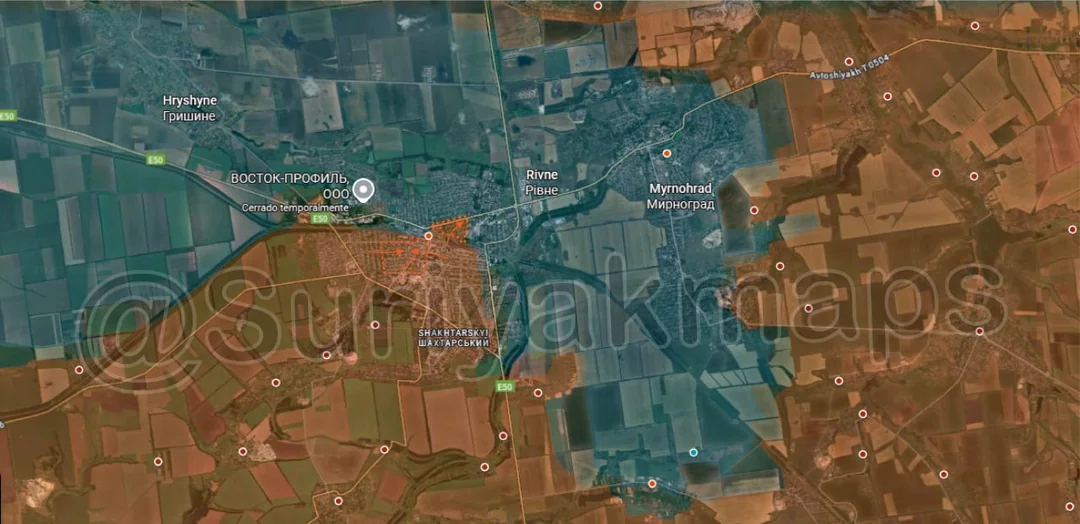
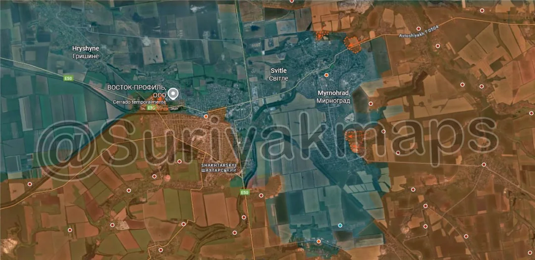
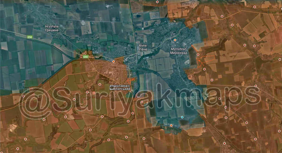
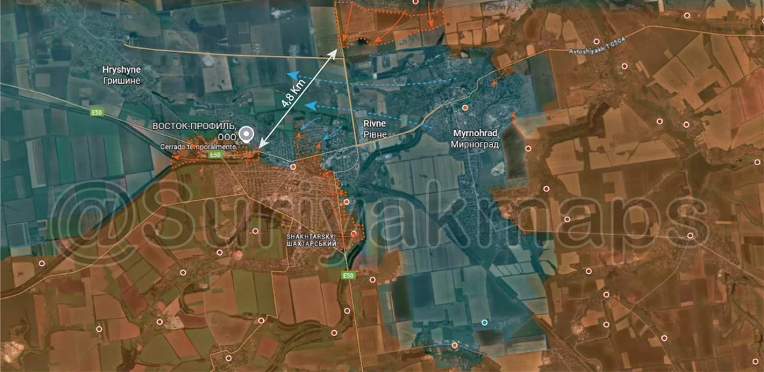
Following on from picture 13, the situation in Pokrovsk has continued to deteriorate for Ukraine and can be described as catastrophic for the garrisons of both cities (plus surrounding areas). On the north side, after securing Rodynske several Russian groups moved south and have set themselves up in the treelines and farm right near the turn off to Hryshyne, effectively physically cutting the road.

To the southwest, Russia now firmly controls the industrial area on the edge of Pokrovsk, including the entrance to the city, and have started moving out into the adjacent streets.

East of this, the Russian troops that entered the eastern suburbs (see picture 13) have captured most of this area and are working on clearing the last streets now. Once done they can link up with the other Russian forces pushing into the northern side of the city to attack the last remaining Ukrainian positions.

Overall, it is an absolute disaster for Ukraine, with the cities functionally encircled (not physically) and the only routes out being under Russian fire control. Suriyak shows the gap between Russian positions as being 4.8km here but even that is an optimistic number as Russian groups have been spotted even deeper into Pokrovsk than shown here. The garrisons of both cities have been trying to flee for a while now, heading out in small groups during the night to try evade Russian drones, but there have been heavy casualties. Other groups are unable to even leave the cities and get picked off trying to make their way out (such as these guys). There is a lot more footage circling online, including many gore-y compilations, but you get the idea. Whatever is left of the garrisons, particularly Myrnohrad, will either have to surrender or wait to be found by the Russians or chance the march through the neck of the pocket.
Russian Forces Advance: 6.41 km²

Advance = 6.41km2

Following on from picture 8, Russian assault groups captured Vyshneve after a few days of fighting (video not uploaded to sub). Vyshneve is a large village with a good amount of buildings that Russian forces can use as a staging point for further pushes west, specifically to Danylivka and Vidradne.

As a bit of a tangent/rant, Ukrainian sources for this front have been almost useless and their reports resemble fanfiction more than reality. I read reports from both sides regarding events on all fronts to get an idea of what is going on and what they claim/want to focus on, and even if both sides lie it can still be handy to know what their PR lines are. But for this front they have been especially useless for about a month now, to the point where I doubt they have any contact with people on the ground anymore. For Vyshneve, I read a report from a Ukrainian source talking about the Russians approaching the settlement from the south and Ukraine holding them off on the outskirts as fighting began. Less than an hour later I watched an edited compilation from a Russian source showing them in full control of Vyshneve, with flags all over the village. Given the time taken to film and edit it would have occurred before the Ukrainian report was even posted, meaning the whole battle started and ended before this source claimed it had even started. I believe this is somewhat related to the issues Ukraine has on this front as they are just completely disorganised and are struggling to put up a fight anywhere, so it wouldn’t surprise me if the command was as clueless as the sources making public claims.