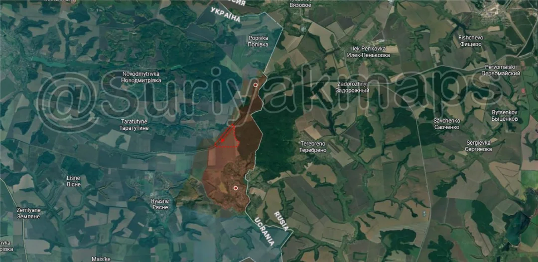
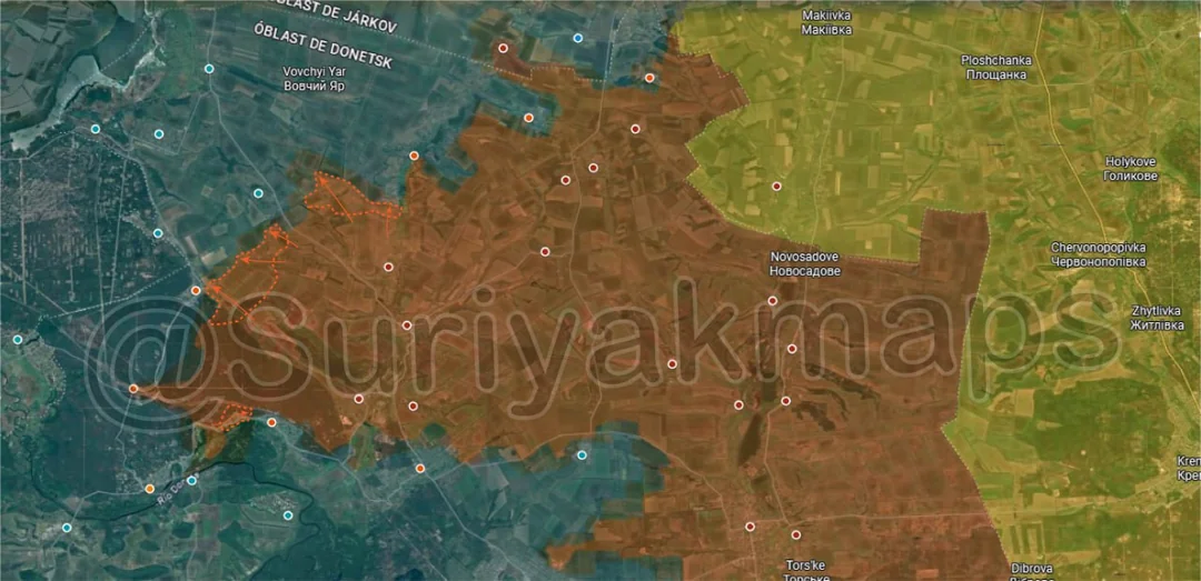
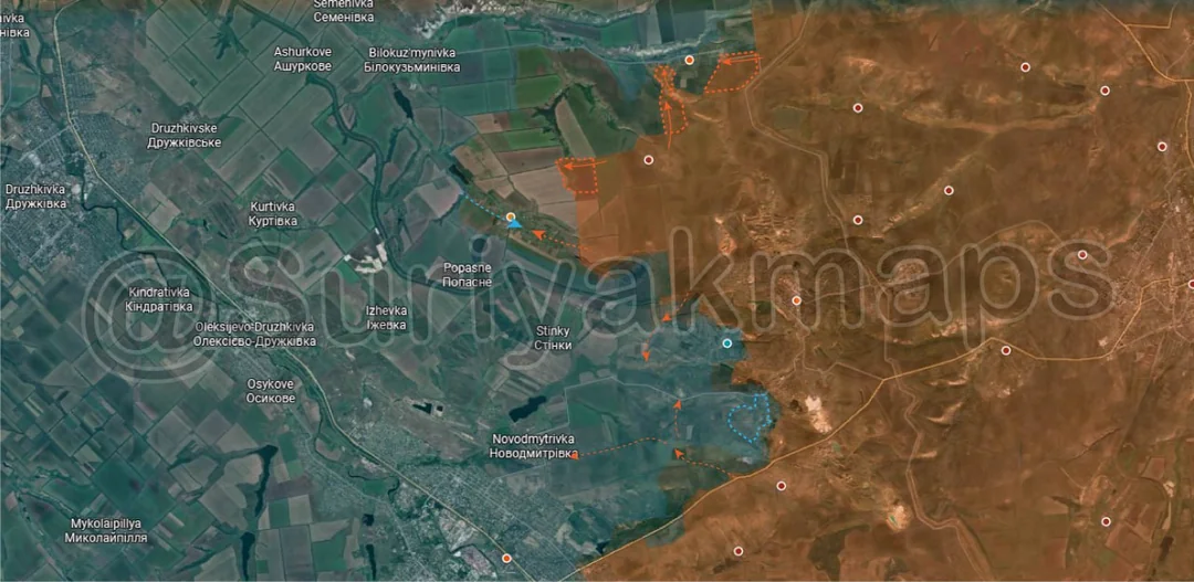
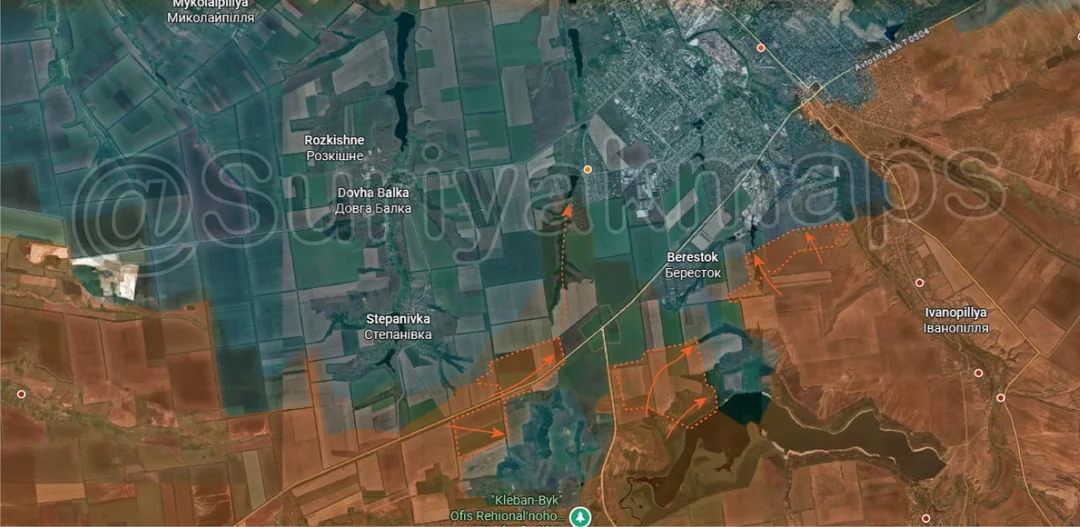
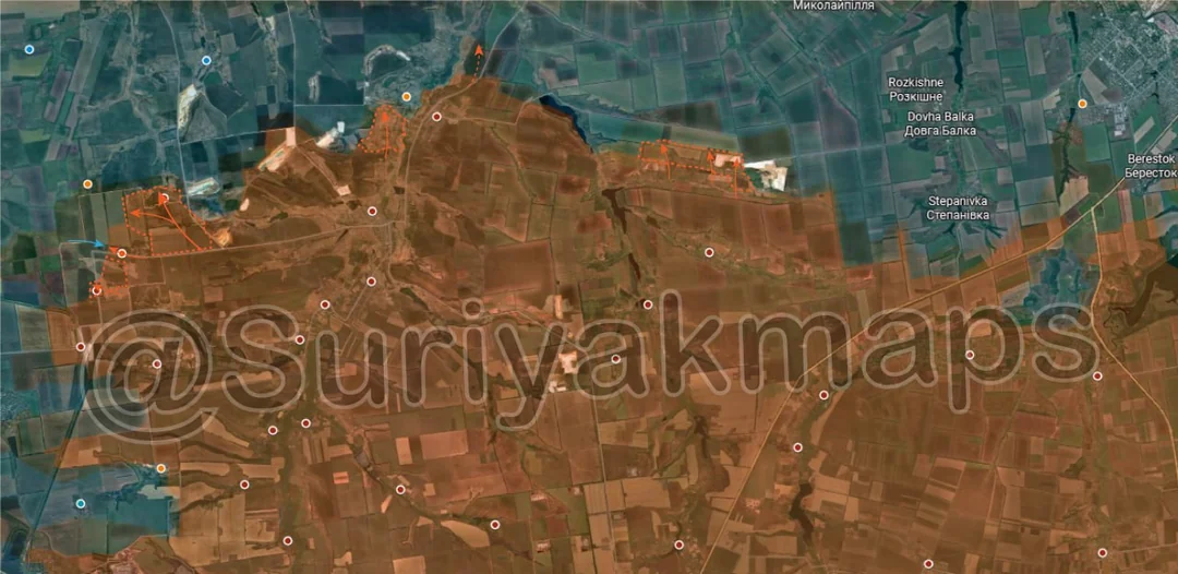
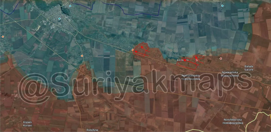
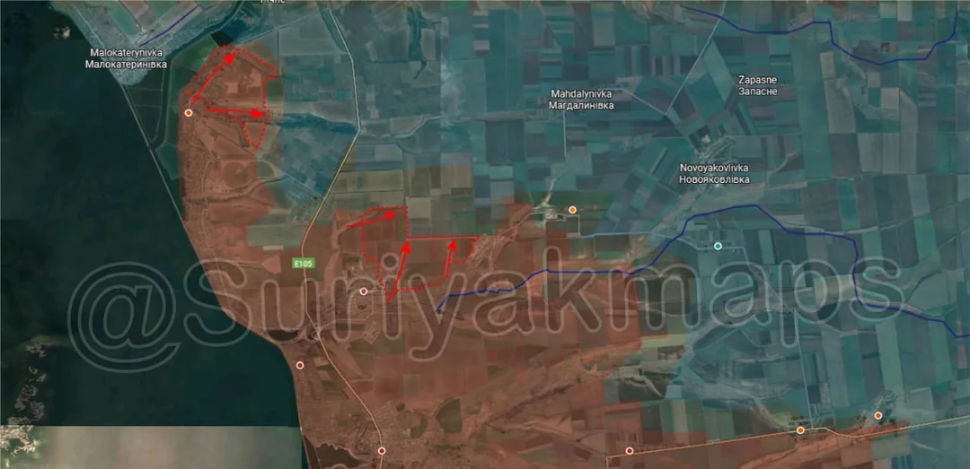
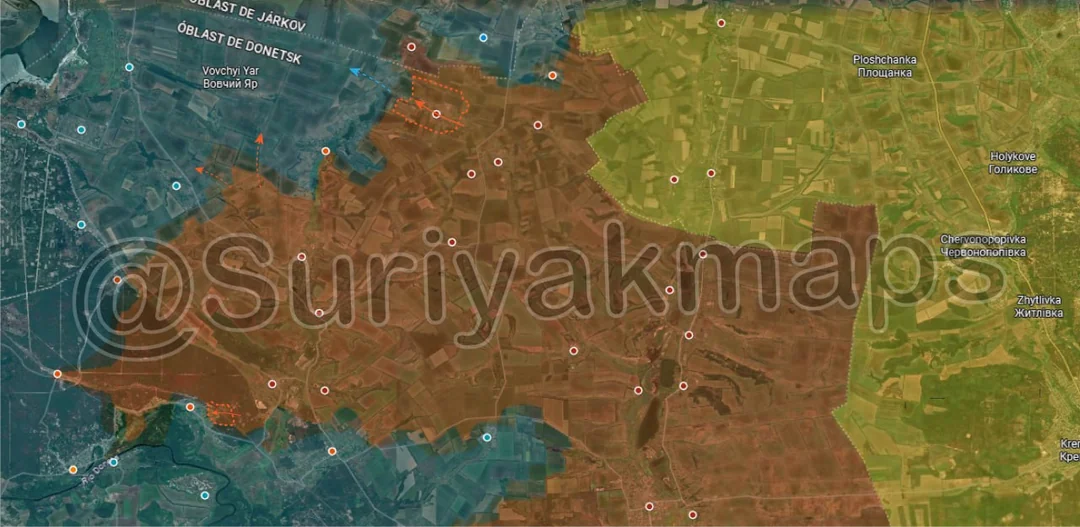
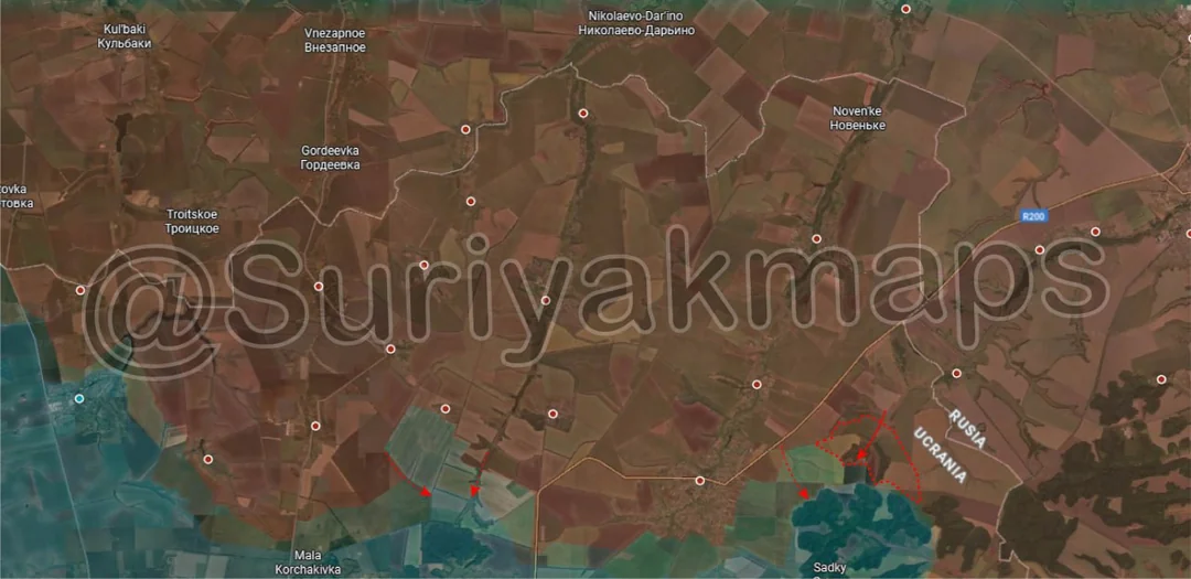
Back home
Post #255

RU POV: Russian and Ukrainian advances from Day 1416 to 1419 of the War - Suriyakmaps

Jan 9, 2026 — Jan 12, 2026 War Day 1416–1419

Pictures 1 to 11 are from Day 1416 to 1417 (Friday 09 to Saturday 10 January), and pictures 12 to 17 are from Day 1418 to 1419 (Sunday 11 to Monday 12 January).

------------------------------------------------------------------------------------------------------

A reminder that these maps are confirming updates from previous days (i.e. typically 12 to 72 hours delayed from each day).

Live map can be found here, Suriyak’s twitter can be found here.

Ukrainian Advance
5.57 km²
Overall (set): 5.57 km²
Russian Advance
84.31 km²
Net Change
-78.74 km²

Situation Snapshots

Imagery, commentary, and territorial changes from the period.

18 entries
Russian Forces Advance: 3.45 km²

Advance = 3.45km2

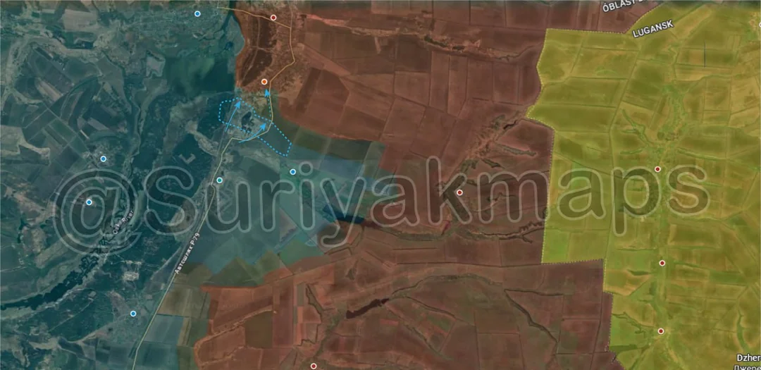
Starting today on the Sumy front, Russia continues to chip away at the area it used to control, recapturing part of the forest north of the Sadky farms over the past few days.
Russian Forces Advance: 0.91 km²

Advance = 0.91km2

Down to the Sumy border area, Russia captured the remaining section of the railway north of Hrabovske between their earlier advances. Still just a minor force here, so don’t expect them to push much further into Ukraine.
Russian Forces Advance: 12.74 km²

Upper Left Advance = 4.28km2, Left Advance = 7.46km2, Lower Left Advance = 1.00km2

Heading to the Oskil River and Lyman fronts, Russia made some larger advances over the past week. On the north side, Russian troops pushed further out from Serednje, capturing more of the treelines east and south of Korovii Yar. Whilst they are right outside the village, they haven’t launched an assault on it quite yet.

A little southwest of this, these same groups also reached the outskirts of Oleksandrivka and entered the easternmost houses. Clashes have begun as Russia tries to establish a foothold in the settlement.

To the south, Russian DRG activity in and around Yarova has borne fruit, with their soldiers now moving into the village in larger numbers and taking over more of the houses on the west side. This does put the locality in a partial encirclement, as the route to Svyatohirsk (west) has been cut and the Russians are dangerously close to occupying the road to Drobysheve.
Russian Forces Advance: 3.20 km²

Top Middle Advance = 0.98km2, Top Right Advance = 1.30km2, Lower Middle Advance = 0.92km2

Onto the Chasiv Yar front, north of the town, Russian forces continue to push around Markove, finally managing to move into the eastern houses and the warehouses on the west side after weeks of attempts. There was also a smaller advance to the west of this, with Russia trying to secure the area around Virolyubivka (currently greyzone), where clashes are taking place.

Further south, Russian DRGs have been probing the various fortifications west of Chasiv Yar, trying to isolate individual Ukrainian groups so they can push the frontline away from the town towards Kostyantynivka. With these movements it was also confirmed that Ukraine holds a slightly larger foothold in southern Chasiv Yar, with the few troops present throughout the Pivdennyi district dug in in random houses. This is more of an annoyance for Russia than a proper Ukrainian hold on this area, as the Ukrainians aren’t even attempting to move around, only hiding and trying to keep whatever they can.
Russian Forces Advance: 6.84 km²

Lower Middle Advance = 1.30km2, Lower Right Advance = 3.42km2, Right Advance = 1.19km2, Bottom Advance = 0.93km2

South of Kostyantynivka, Russia has had further successes and looks to have possibly cracked the Ukrainian defence after months of skirmishes and trading blows. On the east side, Russia secured more of the treelines next to the city, putting them in a better position to try gain a foothold in southern Kostyantynivka or to attack Berestok from the east.

Southwest of that, Russian assault groups captured most of the remainder of the forest north of the reservoir, forcing the few Ukrainians present to retreat. The remaining section should be cleared soon, which will allow Russia to set up drone teams in the forest who can harass the Ukrainian garrison of Kostyantyivka (current positions are a bit further than is ideal).

To the west other Russian forces have made advances along the highway, cutting off a small area north of Yablunivka (off map). If there are any Ukrainian troops left here, their chances of making it out are slim as they would have to cross a lot of open ground to get to Berestok or chance a breakout through active Russian assault groups.

The dotted arrow towards Illinivka I talked about last post, but since then there have been further Ukrainian reports that this is no longer just some DRGs poking around the settlement, but multiple Russian assault groups that are successfully building up their presence in the ravine and are trying to take over Ilkinivka.
Russian Forces Advance: 9.27 km²

Top Left Advance = 1.43km2, Top Right Advance = 2.73km2, Upper Left Advance = 4.22km2, Far Left Advance = 0.89km2

Moving to the Dobropillya front, on the northeast side, Russia restarted operations north of Rusyn Yar (above the k), recapturing part of the Rusinovskoye quarry and adjacent treelines.

To the west, over the past few days Russia has managed to capture the trench network north of Shakhove and push into the first houses of Toretsk. This will be a rather important battle, as Russia will need to crack the fortifications here if they wish to push on north and northeast towards the city of Druzhkivka.

To the southwest, Russia managed to recapture Chernyavskiy (mining settlement) and Ivanivka, as Ukraine tried to push back into Nove Shakhove. This is a growing area of concern for Ukraine, as Russia is gradually recapturing the former salient area with less resistance than expected, except this time they have significantly better flanks and more supporting forces than when the breakthrough occurred last August. There is technically only 1 village (Novyi Donbas), between the Russians and the city of Dobropillya (off map west), although it’s extremely unlikely they would attack it from this side.
Ukrainian Forces Advance: 2.47 km²

Advance = 2.47km2

Out west of Pokrovsk, the back and forth fighting continues, with Russian DRGs moving out into the area west of the coal mine, whilst Ukraine attempts to push back down towards Kotlyne.
Context

No Advance

Over in Novopavlivka, over the past couple of weeks Russian groups have been trying to sneak their way into and around the town, expanding the greyzone as Ukraine’s grip on the locality begins to slip. Ukraine will need to launch another large counterattack as they did last time if they are to avoid losing the settlement, but it is questionable if they currently have the troops available to do so.
Russian Forces Advance: 20.21 km²

Top Advance = 4.88km2, Middle Advance = 13.05km2, Bottom Advance = 2.28km2

Heading to the Hulyaipole front, on the north side, Russia cleared out the Ukrainian assault groups that had tried to push east during the bad weather a little while ago, resecuring northern Varvarivka. In this same spot, some infantry crossed the Haichur River and took over the southern houses of Pryluky, a minor village that Ukraine has limited ability to hold as it was too close to Russian lines.

To the south, Russian assault groups pushed out of Hulyaipole and captured the village of Zelene, as well as the surrounding fields and treelines. They’ve quickly moved west, reaching the easternmost houses of Sviatopetrivka. As you can see by the dark blue line, this is where the 2nd layer of the Zaporizhia defence line curves, so Russia will be trying to see if they can crack this corner and breach the line to link up with the crossings further north.

Southwest of Hulyaipole, there was also a minor advance through the treelines, with Russia slowly expanding the buffer around the town.
Russian Forces Advance: 4.66 km²

Upper Middle Advance = 2.02km2, Middle Right Advance = 2.64km2

Heading to the Orikhiv front, over the past 2 weeks Russia restarted operations next to Bilohirya, capturing the village quite easily. The locality has sat next to the frontline for years now, with the Russians entering it several times before, however they always withdrew as the settlement had minimal value and they didn’t intend to push north towards the Ukrainian fortification line. The Russian capture looks to be linked to problems with the Ukrainian 102nd TDF Brigade (expanded in a comment below), so perhaps they will try push this area for the first time.

Out west, after regrouping in eastern Mala Tokmachka following the Ukrainian counterattacks in December, Russian forces have once again pushed back into the centre of the town. This battle has been an ongoing slog for a long time now, so I don’t expect to see many changes or the securing of the town by either side.
Russian Forces Advance: 10.87 km²

Top Left Advance = 4.98km2, Middle Left Advance = 5.89km2

Over on the Zaporizhia front, the situation has further deteriorated for Ukraine. On the northwest side, Russian assault groups captured most of the remainder of Prymorske, with just the northern dachas remaining. This puts Russia within striking distance of Richne (slightly off map north) and more importantly the bridge over the Konka River in Hryhorivka. I can’t really comment on Ukraine’s defence here, as following the withdrawal of whatever remained of their infantry in Prymorske over a week ago we have seen minimal from them. I suspect they have set up in Richne and the Dachas next to the E105 highway (very top of map), trying to prevent Russian from getting through to Veselyanka.

Further south, the bad news continued. Russia cleared out the remainder stragglers in the ruins of Stepnohirsk, capturing the town. It’s possible there may be a couple still hiding in the basements of some houses, but any proper resistance has long since ceased. Russian troops have immediately pushed out north and northeast, capturing a number of surrounding treelines and a couple of fortifications. The capture of Stepnohirsk now opens the way for Russia to push into the open area between Prymorske and Mahdalynivka, which has almost no fortifications and minimal Ukrainian troops present.
Context

No Advance

Swinging up to the Kupyansk front, the chaotic mess continues, with Russian DRGs infiltrating even further into Podoly, reaching the southernmost houses right next to Kupyansk-Vuzlovyi. Ukraine needs to get a grip on these areas, as its clear that they are unable to stop these Russian DRGs from walking through their lines.

In central Kupyansk, there has been more back and forth, with Russian and Ukrainian troops trying to push through each other’s positions on the east and west side of the town.
Ukrainian Forces Advance: 2.18 km²

Advance = 2.18km2

Back to the Oskil River front, this time the far northern side where Ukraine’s attacks into Zahryzove are ongoing. Over the past week they have made a little progress, capturing the southernmost street of the village.
Russian Forces Advance: 6.57 km²

Top Advance = 5.73km2, Bottom Left Advance = 0.84km2

Following on from picture 3, on the northern side, after many months of skirmishes Russia finally recaptured the village of Ridkodub, with little fanfare. This was the village that saw constant Ukrainian counterattacks from June through September 2025, with their command pushing more and more troops. Whilst it came at a cost, it was effective as it completely halted the Russian western advance in this area, although they simply went southwest instead. When the Ukrainian 3rd Assault Brigade was redeployed to Kupyansk in September 2025 the Ukrainian counterattacks mostly stopped, although they kept moving troops into to hold the area. From what I could gather the Russian unit in this area just quietly chipped away at the defenders before moving back in and through the village. It is unlikely we will see much more movement here, as the bulk of the Russian army on this front is focusing on Lyman, so there are few troops available to restart a push west here.

To the southwest, Russian troops began to move into eastern Yarova, taking up positions in the houses. Whatever remains of the Ukrainian garrison will need to withdraw now, or risk being operationally encircled in the village.
Russian Forces Advance: 2.42 km²

Advance = 2.42km2

On the southern edge of the Lyman front, whilst clashes continued in Ozerne, Russia cleared out the last of the treelines to the east of the village.
Russian Forces Advance: 1.43 km²

Advance = 1.43km2

Following on from picture 5, Russian troops occupied the large trench network next to the highway leading into Kostyantynivka, encircling the small area to the south. The Russians are currently clearing it out now, so if any Ukrainian troops didn’t withdraw a while ago they will be wiped out or captured in the coming days.

There has also been increased Russian activity west of Stepanivka, although no confirmed assault on the village itself.
Russian Forces Advance: 1.74 km²

Advance = 1.74km2

Following on from picture 9, the previously mentioned Russian troops captured the rest of Pryluky and some of the adjacent fields. For now they are not trying to push any further west, instead trying to expand the width of the bridgehead over the Haichur River.
Ukrainian Forces Advance: 0.92 km²

Top Left Advance = 0.92km2

From Picture 4