Russian Forces
Advance: 8.54 km²
Left Advance = 4.13km2, Centre Advance = 1.32km2, Right Advance = 3.09km2
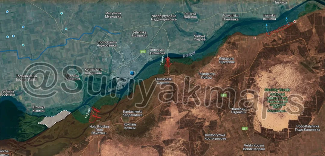
Lots of interesting developments happened in Kherson Oblast over the past 2 weeks. With Ukraine pulling many units off of different areas of the frontline to send north to counter the Russian attack there, Ukraine's Kherson operations were no longer feasible. Several of the units that were based in Kherson were rapidly redeployed north, leaving the remaining Ukrainian forces even more undermanned and understrength than they already were.
To start, Ukraine finally pulled whatever units it had left out of Krynky, ending the disastrous operation once and for all. I'll expand on Krynky in a comment below, but suffice to say the operation was a catastrophe for Ukraine, failed to meet its objectives, and primarily ended up doing more damage to Ukraine than it did to Russia.
With Ukraine's forces in this area weakened, Russia has been able to begin operations of its own. Small Russian squads have begun to push out into the river delta, capturing parts of some of the islands near Hola Prostan, and capturing the grey zone leading up the destroyed Antonovskiy Bridge. Whilst they have become more active, do not expect Russia to suddenly try land on the opposite bank of the river. These operations are more to capture areas they had to cede to Ukraine long ago, and now there is less threat of being attacked, they can retake them.
Nestryga island (white outline left side) has gone back into the grey zone, having been 'captured' by Ukraine 2 months ago. As I said back then, the island serves essentially no benefit to either side, being a thick marsh, almost entirely waterlogged, and having zero permanent structures there. Russian forces landed on the island and claimed control similar to how Ukraine did, but did not stay. For now, both sides claim to 'control' the island, when in reality neither of them do.